U.S. Geological Survey Open-File Report 2010–1007
Sea-Floor Geology and Character Offshore of Rocky Point, New York
 |
||
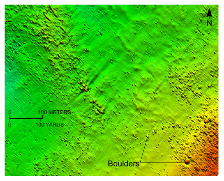
Figure 17. Detailed planar view of the bouldery sea floor off Rocky Point, New York, from the digital terrain model produced during National Oceanic and Atmospheric Administration survey H11251. Boulders rest on the winnowed upper surface of the submerged Harbor Hill-Roanoke Point-Orient Point moraine. Location of view is shown in figure 16. | ||

![]() U.S. Department of the Interior |
U.S. Geological Survey
U.S. Department of the Interior |
U.S. Geological Survey
URL: https://pubsdata.usgs.gov/pubs/of/2010/1007/html/fig17.html
Page Contact Information: Contact USGS
Page Last Modified: Wednesday, 07-Dec-2016 22:38:09 EST


