U.S. Geological Survey Open-File Report 2010–1007
Sea-Floor Geology and Character Offshore of Rocky Point, New York
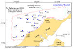
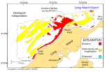
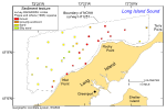
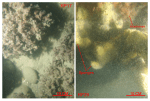
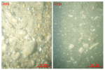
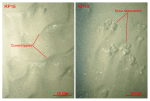
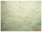
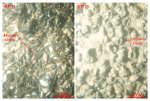
Gravel (all sediment greater than 2 mm in nominal diameter including boulders) is the dominant surficial sediment off Rocky Point and in shallow water along the western shoreline (figs. 19, 27). Boulders, where present, are typically covered by sessile flora and fauna (fig. 28), suggesting that they are immobile even during severe storms. In places (for example, station RP9), seaweed grows in between the boulders. The seaweed and sessile biota are ecologically important because they also add dramatically to the overall benthic roughness. Finer grained gravels (for example, pea gravels and cobbles) and gravelly sediments are present adjacent to the bouldery deposits (fig. 29). Together these sediments are prevalent in shallow, high-energy areas characterized by sedimentary processes associated with erosion and nondeposition. The Holocene section in these areas is thin or absent (Lewis and Needell, 1987; Poppe and others, 2002), suggesting that finer grained sediments have been winnowed away, leaving coarser lag deposits on the submerged surface of the Harbor Hill-Roanoke Point-Orient Point moraine. Sand is the dominant textural class of the sediment offshore west of Rocky Point, on top of Orient Shoal, and in the protected area between Rocky and Terry Points (fig. 27). Coarse and very coarse sand dominates near the gravelly deposits off Rocky Point (for example, stations RP14, RP15, RP18), but the sediments progressively fine southwestward toward the medium- and fine-grained sands that are more prevalent off Inlet Point (for example, stations RP20, RP22, RP23). Medium- and fine-grained sand is also more prevalent in protected areas, such as between Rocky and Terry Points. Much of the sea floor in the offshore sandy areas is covered with sand waves and megaripples, and the stoss slopes of these bedforms are covered in current ripples (figs. 19, 30). These bedforms reflect sedimentary environments characterized by processes associated with coarse bedload transport; their architecture and the presence of smaller bedforms on the slopes of the sand waves suggest that transport is ongoing. Shell hash, organic debris, and coarser sediments are commonly found in the ripple troughs; scour features are often present around larger shells and other obstructions (fig. 30). Ripples are fainter and burrows are more common on the relatively flat sea floor away from the sand-wave fields (fig. 31). Sorting of the sandy sediments is generally moderate to poor regardless of location. A small patch of silty sand is present offshore between Rocky and Inlet Points. This deposit is composed of a thin (less that 1–cm thick) layer of clean sand overlying muddier sediments. Shell beds are common adjacent to rockier parts of the study area (fig. 32). Tidal and wave currents there are apparently strong enough to hydraulically concentrate the shells (for example, stations RP11, RP19). These shell beds are typically thin and presumably ephemeral. Mussel shells constitute most of the shell debris off Rocky Point; slippersnail (Crepidula) shells are more prevalent at stations elsewhere along the shoreline. These shell beds are ecologically important because they form sea-floor habitats of rough, relatively hard substrates that add considerably to the overall benthic compositional complexity. Bottom photography shows that infauna construct burrows in the shell deposits, juvenile finfish shelter between the shells, and sessile fauna and flora attach themselves to the hard substrate provided by the shells. Sediment DataThe sediment grain-size dataset provided here contains information on the collection, location, description, and texture of sediments at 19 stations occupied during the 2009 RV Rafael verification cruise 09059 (figs. 12, 27). All analyses were conducted in the sedimentation laboratory at the USGS Woods Hole Coastal and Marine Science Center. Records without textural data and statistics are based on visual descriptions. The basic structure of the data is a flat-file format, a matrix where records are rows representing individual samples and the columns contain sample- and station-specific information. This matrix consists of 42 fields, which are defined in the Data Dictionary below. The sediment data are provided in two formats: Microsoft Excel and delimited ASCII text format. In the delimited ASCII text file, each field or column of data is separated from the next by a comma and can be downloaded into many types of software. Data DictionaryAn integral part of any database is the dictionary that explains the structure and content. It contains a list of the fields and the definitions of parameters measured. Data utilization is facilitated by reference to this compilation because it defines abbreviations and lists field names. LABNO - Unique sample identifier assigned in the laboratory STATIONID - Sample name or number assigned in the field PROJECT - Project under which samples were taken or data generated CRUISEID - Name or number of cruise on which sample was collected or station occupied PRINCIPAL - Name of principal investigator LATITUDE - Latitude in decimal degrees LONGITUDE - Longitude in decimal degrees (west longitudes are negative values) DEPTH_M - Depth of water measured by a hull-mounted fathometer overlying sediment at the time of sampling, not corrected for tides, in meters T_DEPTH - Top depth of the sample below the sediment-water interface, in centimeters B_DEPTH - Bottom depth of the sample below the sediment-water interface, in centimeters DEVICE - Device used to collect the sample MONTH - Number of calendar month during which the sample was collected DAY - Calendar day on which the sample was collected YEAR - Calendar year during which the sample was collected WEIGHT - Dry weight of sample, in grams ZGRAVEL - Gravel content in percent dry weight of the sample (particles with nominal diameters greater than 2 millimeters; -1 phi and larger) ZSAND - Sand content in percent dry weight of the sample (particles with nominal diameters less than 2 millimeters but greater than or equal to 0.0625 millimeter; 0 through 4 phi, inclusive) ZSILT - Silt content in percent dry weight of the sample (particles with nominal diameters less than 0.0625 millimeter but greater than or equal to 0.004 millimeter; 5 through 8 phi, inclusive) ZCLAY - Clay content in percent dry weight of the sample (particles with nominal diameters less than 0.004 millimeter; 9 phi and smaller) SEDCLASS - Sediment description based on a rigorous definition (Shepard, 1954) MEDIAN - Middle point in the grain-size distribution, in phi units MEAN - Average value in the grain-size distribution, in phi units STDDEV - Standard deviation (root mean square of the deviations) of the grain-size distribution, in phi units (that is, sorting) SKEWNESS - Deviation from symmetrical form of the grain-size distribution KURTOSIS - Degree of curvature near the mode of the grain-size distribution PHI _11 - Weight percent of the sample in the 11 phi fraction (nominal diameter of particles greater than or equal to 0.0005 millimeter but less than 0.001 millimeter); fine clay PHI_10 - Weight percent of the sample in the 10 phi fraction (nominal diameter of particles greater than or equal to 0.001 millimeter but less than 0.002 millimeter); medium clay PHI_9 - Weight percent of the sample in the 9 phi fraction (nominal diameter of particles greater than or equal to 0.002 millimeter but less than 0.004 millimeter); coarse clay PHI_8 - Weight percent of the sample in the 8 phi fraction (nominal diameter of particles greater than or equal to 0.004 millimeter but less than 0.008 millimeter); very fine silt PHI_7 - Weight percent of the sample in the 7 phi fraction (nominal diameter of particles greater than or equal to 0.008 millimeter but less than 0.016 millimeter); fine silt PHI_6 - Weight percent of the sample in the 6 phi fraction (nominal diameter of particles greater than or equal to 0.016 millimeter but less than 0.031 millimeter); medium silt PHI_5 - Weight percent of the sample in the 5 phi fraction (nominal diameter of particles greater than or equal to 0.031 millimeter but less than 0.0625 millimeter); coarse silt PHI_4 - Weight percent of the sample in the 4 phi fraction (nominal diameters of particles greater than or equal to .0625 millimeter but less than 0.125 millimeter); very fine sand PHI_3 - Weight percent of the sample in the 3 phi fraction (nominal diameter of particles greater than or equal to 0.125 millimeter but less than 0.25 millimeter); fine sand PHI_2 - Weight percent of the sample in the 2 phi fraction (nominal diameter of particles greater than or equal to 0.25 millimeter but less than 0.5 millimeter); medium sand PHI_1 - Weight percent of the sample in the 1 phi fraction (nominal diameter of particles greater than or equal to 0.5 millimeter but less than 1 millimeter); coarse sand PHI_0 - Weight percent of the sample in the 0 phi fraction (nominal diameters of particles greater than or equal to 1 millimeter but less than 2 millimeters); very coarse sand PHIM1 - Weight percent of the sample in the -1 phi fraction (nominal diameter of particles greater than or equal to 2 millimeters but less than 4 millimeters); very fine pebbles (granules) PHIM2 - Weight percent of the sample in the -2 phi fraction (nominal diameter of particles greater than or equal to 4 millimeters but less than 8 millimeters); fine pebbles PHIM3 - Weight percent of the sample in the -3 phi fraction (nominal diameter of particles greater than or equal to 8 millimeters but less than 16 millimeters); medium pebbles PHIM4 - Weight percent of the sample in the -4 phi fraction (nominal diameter of particles greater than or equal to 16 millimeters but less than 32 millimeters); coarse pebbles PHIM5 - Weight percent of the sample in the -5 phi fraction (nominal diameter of particles greater than or equal to 32 millimeters); very coarse pebbles to boulders |

![]() U.S. Department of the Interior |
U.S. Geological Survey
U.S. Department of the Interior |
U.S. Geological Survey
URL: https://pubsdata.usgs.gov/pubs/of/2010/1007/html/seds.html
Page Contact Information: Contact USGS
Page Last Modified: Wednesday, 07-Dec-2016 22:38:25 EST