Skip past header information
USGS - science for a changing world
NOAA Logo with link to NOAA Home Page.CT DEP Logo with link to CT DEP Home Page.  

U.S. Geological Survey Open-File Report 2010–1007

Sea-Floor Geology and Character Offshore of Rocky Point, New York


Bathymetry

Skip past contents information
Click on figures for larger images
Thumbnail image of figure 15 and link to larger figure. Digital terrain model of the sea floor produced from the multibeam bathymetry collected during National Oceanic and Atmospheric Administration survey H11251 and gridded to 2 m.
Figure 15. Digital terrain model of the sea floor produced from the multibeam bathymetry collected during National Oceanic and Atmospheric Administration survey H11251 and gridded to 2 m.
Thumbnail image of figure 16 and link to larger figure. Locations of detailed planar views of the digital terrain model and sidescan-sonar mosaic (yellow polygons) and profiles of sand-wave symmetry (green lines).
Figure 16. Locations of detailed planar views of the digital terrain model and sidescan-sonar mosaic (yellow polygons) and profiles of sand-wave symmetry (green lines).
Thumbnail image of figure 17 and link to larger figure. Detailed planar view of the bouldery sea floor off Rocky Point from the digital terrain model produced during National Oceanic and Atmospheric Administration survey H11251.
Figure 17. Detailed planar view of the bouldery sea floor off Rocky Point from the digital terrain model produced during National Oceanic and Atmospheric Administration survey H11251.
Thumbnail image of figure 18 and link to larger figure. Detailed planar view of the bouldery sea floor along the shoreline in the vicinity of Inlet Point from the digital terrain model produced during National Oceanic and Atmospheric Administration survey H11251.
Figure 18. Detailed planar view of the bouldery sea floor along the shoreline in the vicinity of Inlet Point from the digital terrain model produced during National Oceanic and Atmospheric Administration survey H11251.
Thumbnail image of figure 19 and link to larger figure. Interpretation of the digital terrain model and sidescan-sonar mosaic from National Oceanic and Atmospheric Administration survey H11251 off Rocky Point, New York.
Figure 19. Interpretation of the digital terrain model and sidescan-sonar mosaic from National Oceanic and Atmospheric Administration survey H11251 off Rocky Point, New York.
Thumbnail image of figure 20 and link to larger figure. Detailed planar view of obstacle marks from the digital terrain model produced during National Oceanic and Atmospheric Administration survey H11251 off Rocky Point, New York.
Figure 20. Detailed planar view of obstacle marks from the digital terrain model produced during National Oceanic and Atmospheric Administration survey H11251 off Rocky Point, New York.
Thumbnail image of figure 21 and link to larger figure. Detailed planar view of Orient Shoal from the digital terrain model produced during National Oceanic and Atmospheric Administration survey H11251 off Rocky Point, New York.
Figure 21. Detailed planar view of Orient Shoal from the digital terrain model produced during National Oceanic and Atmospheric Administration survey H11251 off Rocky Point, New York.
Thumbnail image of figure 22 and link to larger figure. Cross-sectional views of sand waves around Orient Shoal from the digital terrain model produced during National Oceanic and Atmospheric Administration survey H11251 off Rocky Point, New York.
Figure 22. Cross-sectional views of sand waves around Orient Shoal from the digital terrain model produced during National Oceanic and Atmospheric Administration survey H11251 off Rocky Point, New York.
Thumbnail image of figure 23 and link to larger figure. Cross-sectional views of sand waves west of Rocky Point from the digital terrain model produced during National Oceanic and Atmospheric Administration survey H11251.
Figure 23. Cross-sectional views of sand waves west of Rocky Point from the digital terrain model produced during National Oceanic and Atmospheric Administration survey H11251.

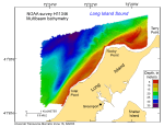
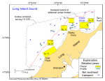
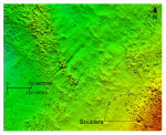
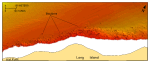
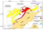
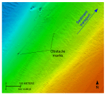
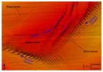
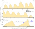
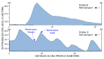
The deepest water depths surveyed within the study area lie about 2.4 km northwest of Rocky Point and exceed 36 m (fig. 15). This depression branches both westward and to the southwest where it roughly parallels the coastline and gives the western part of the study area a steeper nearshore to offshore gradient. The shallowest areas are found along the shorelines and on Orient Shoal (fig. 16), an isolated bathymetric high northeast of Rocky Point.

Many small, individual, rounded bathymetric highs are also concentrated in a broad band extending off Rocky Point and along shorelines. These features, which give the sea floor in these areas a rough appearance, are interpreted to be boulders (figs. 16, 17, 18, 19). Although the boulders average 1 to 5 m in width, many exceed 10 m, and the largest exceeds 18 m across. These rocky areas are lag deposits remaining from the winnowed sediments of the Harbor Hill-Roanoke Point-Orient Point moraine. In places, turbulence from the strong tidal currents flowing around boulders has scoured the sea floor on the lee side of the boulders creating features called comet or obstacle marks (fig. 20).

Elsewhere, most of the study area's benthic bathymetric complexity consists of the alternating narrow, elongate bathymetric highs and lows revealing the crests and troughs of adjacent sand waves and megaripples (figs. 19, 21). These fields of bedforms occur (1) in northeast-trending bands in the western part of the study area, where the wave crests trend northwest-southeast, (2) around Orient Shoal, where wave crests are roughly perpendicular to the shoal's flanks, and (3) in small isolated patches adjacent to the exposed boulders off Rocky Point. Both transverse and barchanoid sand waves are present, but transverse waves are more common where sediment supply is abundant, such as near Orient Shoal, and the barchanoid waves are more common in the small isolated patches where sand supply is limited. Amplitudes of the larger transverse bedforms exceed 3 m, and wavelengths can exceed 100 m. Crest to trough amplitudes of the largest barchanoid sand waves exceed 5.6 m.

Asymmetry in the comet marks and sand waves can be used to interpret directions of net sediment transport (figs. 16, 20, 22, 23). For example, the tails of comet marks extend downstream in the transport direction and stoss slopes of sand waves face upstream. Bedform asymmetry indicates that nearshore transport is predominantly eastward, but offshore transport is primarily westward in the northern and western parts of the study area. Sand-wave asymmetry adjacent to Orient Shoal indicates clockwise sediment transport is important to shoal morphology and maintenance.


Accessibility FOIA Privacy Policies and Notices

Take Pride in America logo USA.gov logo U.S. Department of the Interior | U.S. Geological Survey
URL: https://pubsdata.usgs.gov/pubs/of/2010/1007/html/bathy.html
Page Contact Information: Contact USGS
Page Last Modified: Wednesday, 07-Dec-2016 22:38:00 EST