Skip past header information
USGS - science for a changing world

U.S. Geological Survey Open-File Report 2010-1091

High-Resolution Geophysical Data Collected Within Red Brook Harbor, Buzzards Bay, Massachusetts, in 2009


Appendix 1—Geospatial Data

Skip past contents information

Data Format and Projection

Vector data: Environmental Systems Research Institute (ESRI) shapefiles, Geographic Coordinate System World Geodetic System 1984 (WGS84).

Raster data: ESRI Grids and georeferenced TIFF images, in meters in Unversal Transverse Mercator (UTM), Zone 19N, WGS84 projection.

Metadata

All spatial data are distributed with Federal Geographic Data Committee (FGDC) compliant metadata in xml, txt, and html formats.

Data Access
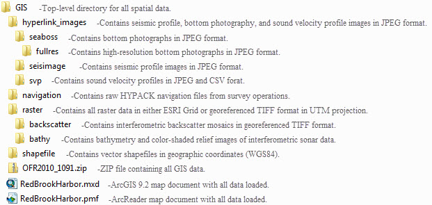
These GIS data can be accessed via DVD-ROM or the Internet. A single ZIP file can be downloaded (OFR2010_1091.zip, 143 MB), or individual layers may be downloaded from the Data Catalog section below. Data are compatible with several software systems, including the following:

Data Organization
The data are organized in the following folders on the DVD-ROM and on the dowloadable ZIP file:

Data Catalog

Vector Data.—Vector data are in shapefile format in geographic coordinates (WGS84). The link in the "Download" column provides access to a Zip file that contains the shapefile.

Layer (metadata) Description Preview Download
RB_BathyBackscatterTrackline Tracklines for swath bathymetry and backscatter survey

RB_BathyBackscatterTrackline.zip

File size: 0.4 MB

RB_BottomPhotos Locations of bottom photographs

RB_BottomPhotos.zip

File size: 0.1 MB

RB_SedimentSamples Locations of sediment samples

RB_SedimentSamples.zip

File size: 0.1 MB

RB_SeismicShot_500 Locations of seismic shotpoints at 500-shot intervals

RB_SeismicShot_500.zip

File size: 0.1 MB

RB_SeismicTrackline Tracklines for seismic profiles

RB_SeismicTrackline.zip

File size: 2.3 MB

RB_SVP Locations of sound velocity profiles

RB_SVP.zip

File size: 0.1 MB


Raster Data.—Raster data are in meters in UTM, Zone 19, WGS84 projection. The link in the "Download" column provides access to a Zip file that contains the raster data.

Layer (metadata) Description Preview Download
RB_Backscatter_1m Interferometric sonar backscatter mosaic, 1-meter pixels (8-bit unsigned TIFF)

RB_Backscatter_1m.zip

File size: 5.3 MB

RB_Backscatter_5m Interferometric sonar backscatter mosaic, 5-meter pixels (8-bit unsigned TIFF)

RB_Backscatter_5m.zip

File size: 0.3 MB

RB_Bathy_1m Bathymetry grid, 1-meter pixels (32-bit floating point ESRI grid)

RB_Bathy_1m.zip

File size: 15.2 MB

RB_Bathy_5m Bathymetry grid, 5-meter pixels (32-bit floating point ESRI grid)

RB_Bathy_5m.zip

File size 0.7 MB

RB_BathyShadedRelief_1m Color-shaded relief image of bathymetry, 1-meter pixels (24-bit unsigned TIFF)

RB_BathyShadedRelief_1m.zip

File size 15.5 MB

RB_BathyShadedRelief_5m Color-shaded relief image of bathymetry, 5-meter pixels (24-bit unsigned TIFF)

RB_BathyShadedRelief_5m.zip

File size 0.7 MB


Hyperlinked Images.—JPEG images that can be linked to by GIS features. The link in the "Download" column provides access to a Zip file that contains the JPEG images.

Layer (metadata) Description Preview Download
RB_BottomPhotos_JPG Bottom photographs

RB_BottomPhotos_JPG.zip

File size: 19.7 MB

RB_BottomPhotosFullRes_JPG.zip

File size: 737 MB

RB_SeismicProfiles_JPG Seismic reflection profile images

RB_SeismicProfiles_JPG.zip

File size: 61.0 MB

RB_SVP_CSV_JPG Sound velocity profile images

RB_SVP_CSV_JPG.zip

File size: 0.6 MB


Navigation Data.—Raw navigation files recorded during survey operations. The link in the "Download" column provides access to a Zip file that contains the raw navigation files.

Layer (metadata) Description Download
RB_Nav Raw navigation files recorded by HYPACK Suvey software during survey operations

RB_Nav.zip

File size: 21.0 MB


Skip USGS links group

Accessibility FOIA Privacy Policies and Notices

Take Pride in America logo USAGov logo U.S. Department of the Interior | U.S. Geological Survey
End of USGS links group