Skip past header information
USGS - science for a changing world
NOAA Logo with link to NOAA Home Page.Massachusetts CZM Logo with link to MA CZM Home Page.  

U.S. Geological Survey Open-File Report 2011–1004

Sea-Floor Geology and Character of Eastern Rhode Island Sound West of Gay Head, Massachusetts


Skip past contents information

Title | List of Figures | Conversion Factors | Abstract | Introduction | Setting | Methods | Bathymetry | Sediment Distribution | Bottom Photography | GIS Data Catalog | Summary | Acknowledgments | References | Contacts


Figure 27. An image of cross-sectional views of sand waves in the study area.

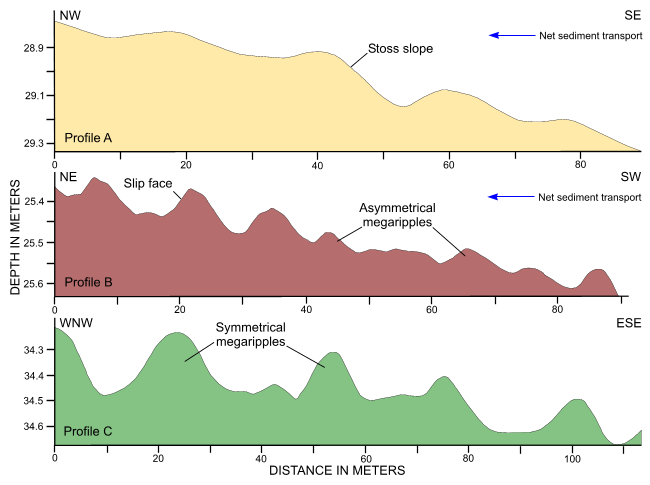
Figure 27. Cross-sectional views of megaripples from the digital terrain model produced from bathymetric data collected during National Oceanic and Atmospheric Administration survey H11922. Bedform asymmetry and slip-face orientation (Reineck and Singh, 1980) indicates net northwestward and northeastward sediment transport in profiles A and B, respectively. The megaripples in profile C are predominantly symmetrical. Locations of profiles are shown in figure 21.

Skip USGS links group

Accessibility FOIA Privacy Policies and Notices

Take Pride in America logo USAGov logo U.S. Department of the Interior | U.S. Geological Survey
End of USGS links group