U.S. Geological Survey Open-File Report 2011–1222
Sea-Floor Geology and Sedimentary Processes in the Vicinity of Cross Rip Channel, Nantucket Sound, Offshore Southeastern Massachusetts
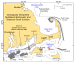
The digital terrain models (DTMs), imagery, interpretive data layers, and data presented herein were derived from multibeam echosounder data collected in Nantucket Sound off southeastern Massachusetts, and from the stations occupied to verify these acoustic data (fig. 1). Basic data layers show sea-floor topography and sun-illuminated shaded relief; an interpretive layer shows the distribution of sedimentary environments. Presented verification data include sediment grain-size analyses and a gallery of still photographs of the seabed. The multibeam data, which cover an approximately 10.4-km² area of sea floor, were collected during 2009 as part of National Oceanic and Atmospheric Administration (NOAA) hydrographic survey H12007 (fig. 1). Although originally collected for charting purposes, these acoustic data, and the data to verify them, provide a fundamental framework for research and management activities along this part of the Massachusetts coastline (Noji and others, 2004), show the composition and terrain of the seabed, and provide information on sediment transport and benthic habitat. This publication is the seventh in a series of digital reports describing the sea-floor geology around Cape Cod. The first focused on the area off the eastern shore of the outer Cape (Poppe and others, 2006); the second on Quicks Hole, a passage through the Elizabeth Islands (Poppe and others, 2007a); the third on Great Round Shoal Channel at the eastern entrance to Nantucket Sound (Poppe and others, 2007b); the fourth in the vicinity of Woods Hole, a harbor and another passage through the Elizabeth Islands (Poppe and others, 2008); the fifth off Edgartown, Martha's Vineyard (Poppe and others, 2010); and the sixth in eastern Rhode island Sound west of Gay Head, Martha's Vineyard (Poppe and others, 2011). Together these publications support the Massachusetts Sea-Floor Mapping Cooperative by supplying geologic and bathymetric maps that extend coverages both inside and outside State waters (Barnhardt and Andrews, 2006). |