Open-File Report 2011-1246
Moderate-Resolution Sea Surface Temperature Data and Seasonal Pattern Analysis for the Arctic Ocean Ecoregions
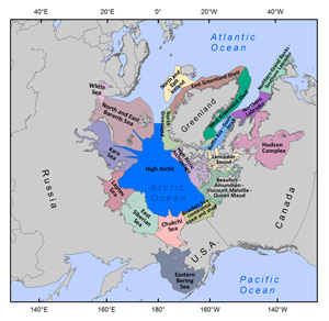
Recent research indicates there has been a warming trend in ocean temperatures over the last 50 years (Intergovernmental Panel on Climate Change, 2007). Notably, a poleward-advancing trend of warming temperatures in the Arctic has been recorded over the last few decades (Corell, 2006). Arctic Ocean regions, especially those subject to the influence of seasonal sea ice pack, are particularly sensitive to this trend. Warming waters at higher latitudes likely jeopardize fragile food webs, pushing habitability of certain ecosystems to the brink for vulnerable species, and increasing the risk of invasion by nonindigenous species (NIS) (Mueter and Norcross, 2002; Gollash, 2006; Herborg and others, 2007; Stram and Evans, 2009). In situ sea surface temperature (SST) measurements typically are made via buoys, or ocean-going vessels, but such measurements are irregular in both space and time. This is especially true in polar regions, where remoteness is compounded by sea ice and ice shelves, making exploration particularly dangerous and expensive. Satellite-based remote-sensing data have the advantage of extensive spatial coverage and high repeatability that is not possible with field observations. The moderate-resolution (4 km) Pathfinder versions 5.0 and 5.1 SST data (hereafter referred to as PFSST data) are derivative products of the data collected by the Advanced Very High Resolution Radiometer (AVHRR) instrument series flown by the National Oceanic and Atmospheric Administration (NOAA) Polar Orbiting Environmental Satellites (POES). These data provide a consistent set of SST measurements of a known quality and calibration for temperature pattern analyses of marine environments in the Arctic Ocean. A value-added Arctic SST product was created by combining processed PFSST data with The Nature Conservancy's Marine Ecoregions of the World (MEOW) biogeographic schema (fig. 1) and is available for download from this open-file report (https://pubs.usgs.gov/of/2011/1246/). Additionally, these data were used to analyze seasonal SST patterns at the ecoregional scale using the MEOW geographical framework.
|
|

![]() U.S. Department of the Interior |
U.S. Geological Survey
U.S. Department of the Interior |
U.S. Geological Survey
URL: http://pubsdata.usgs.gov/pubs/of/2011/1246/introduction.html
Page Contact Information: GS Pubs Web Contact
Page Last Modified: Thursday, 08-Dec-2016 00:16:36 EST