Open-File Report 2014-1160
![]() Title | List of Figures | Conversion Factors | Abstract | Introduction | Setting | Methods | Bathymetry | Sediments | Bottom Photography | GIS Data Catalog | Summary | Acknowledgments | References Cited | Contacts |
Index
Title | List of Figures | Conversion Factors | Abstract | Introduction | Setting | Methods | Bathymetry | Sediments | Bottom Photography | GIS Data Catalog | Summary | Acknowledgments | References Cited | Contacts |
Index
 |
||
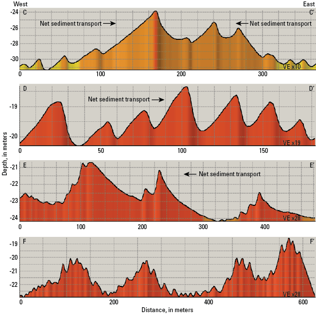
Figure 16. Profiles of sand waves to the northwest (C-C’ and D-D’) and southwest (E-E’ and F-F’) of Cerberus Shoal. Sand waves northwest of the shoal indicate that converging net sediment transport maintains a bathymetric high (C-C’) and that elsewhere there is generally eastward transport (D-D’). In the southwest, there is net westward sediment transport (E-E’), and there are areas without a dominant transport direction (F-F’). Locations of profiles D-D’ and E-E’ are shown in figure 15, location of F-F’ is shown in figure 20, and all profile locations are shown in figure 12. VE, vertical exaggeration. |
||

![]() U.S. Department of the Interior |
U.S. Geological Survey
U.S. Department of the Interior |
U.S. Geological Survey
URL: http://pubsdata.usgs.gov/pubs/of/2014/1160/html/ofr2014-1160-fig16.html
Page Contact Information: GS Pubs Web Contact
Page Last Modified: Wednesday, 07-Dec-2016 19:37:41 EST
