USGS - science for a changing world

FISC - St. Petersburg

Coastal & Marine Geology Program > Center for Coastal & Watershed Studies > Professional Paper 1751

Systematic Mapping of Bedrock and Habitats along the Florida Reef Tract—Central Key Largo to Halfmoon Shoal (Gulf of Mexico)

USGS Professional Paper 1751

by Barbara H. Lidz, Christopher D. Reich, and Eugene A. Shinn

Introduction:
Table of Contents
Project Overview
Project Objective
Geologic Setting
Primary Datasets
Primary Products - Overview Maps & Evolution Overview:
Bedrock Surface map.
Introduction
Depth to Pleistocene Bedrock Surface
Reef & Sediment Thickness
Benthic Ecosystems & Environments
Sedimentary Grains in 1989
Summary Illustration Index Map
Evolution Overview
Tile-by-Tile Analysis
Satellite image of the Florida Keys showing location of tiles.
Organization of Report
Tiles: 1, 2, 3, 4,
5, 6, 7/8, 9/10,
11
Summary
Acknowledg-
ments
References
Disclaimer
Related
Publications

Tile 2

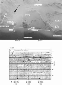
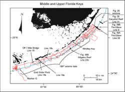
Davis and Alligator Reefs: Davis and Alligator Reefs are two of several named reefs that lie offshore from Plantation and Tavernier Keys (Figs. 42B, 48B, 49A). Davis and Alligator Reefs, located ~11 km apart, consist of Holocene Acropora palmata on top of the fossil shelf-margin reef. A seismic profile acquired near Alligator Reef shows that a sandy strip behind and paralleling the reef is a sand-filled bedrock depression (Figs. 49A, 49B, 50).

(A) Aerial photo (1991) shows the discontinuity of the shelf-margin reef. (B) Seismic profile (1997) shows that the line of sand represents a sediment-filled,  trough-like bedrock depression. Figure 49. (A) Aerial photo (1991) shows the discontinuity of the shelf-margin reef, here due to a basin-like reentrant in the area of Alligator Reef, located ~11 km southwest of Davis Reef (modified from Lidz et al., 2003; Figs. 42B, 48B). Note concavity of the shelf-margin reef (white dotted line) and narrow width of the upper-slope terrace in front of the reentrant. 'Tripod' symbol shows location of Alligator Reef Light. Diagonal labeled 'Line 22b' west of tripod indicates approximate location of seismic profile shown in (B). Arrow next to Line 22b diagonal points to a margin-parallel line of sand behind the shelf-edge reef. (B) Seismic profile (1997) shows that the line of sand represents a sediment-filled, trough-like bedrock depression (from Lidz et al., 2003). Linearity of the line of sediment in (A) and its orientation normal to the seismic line indicates the image of the depression in this profile is probably its true shape. D wave = direct arrival (not a geologic surface). Holocene = the most recent 10 ka. 'Multiples' are an artifact common in seismic-reflection data. These reflections replicate those of existing, overlying, geologic surfaces and should not be regarded as representing any subsurface stratigraphic horizon. Latitude and longitude in degrees and decimal minutes based on GPS coordinates. Hours (military time) below coordinates serve as navigational correlation points along seismic line. [larger version]

Index map shows U.S. Geological Survey seismic tracklines (red) in the upper and middle Florida Keys Figure 50. Index map shows USGS seismic tracklines (red) in the upper and middle Florida Keys and those portions of profile data selected (bold black) from the Tile 1 and Tile 2 sectors for illustration with their figure numbers (Tile 2, Fig. 49B; modified from Lidz et al., 2003). Shelf-margin contour (blue) is in meters. [larger version]

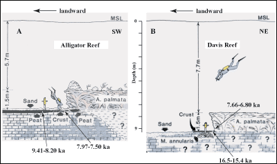
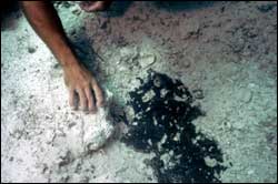
These two reefs were the sites of an early study to sample offshore soilstone crust and mangrove peat for radiocarbon dating (Robbin, 1984). Soilstone crusts have long been recognized as valuable indicators of exposure to air (e.g., Multer and Hoffmeister, 1968; James, 1972; Harrison, 1977; Perkins, 1977), and mangrove peat is a valuable indicator of shoreline locations. Crusts occur at the bases of ledges on the landward side of Alligator and Davis Reefs in water depths of 7.2 and 9.2 m, respectively (Fig. 51A, 51B). The sites are deep enough that an airbag is required to lift the drill and core barrel to the surface (Fig. 52). The Davis Reef soilstone encrusted the top of a buried Montastrea annularis coral (Figs. 51B, 53). At Alligator Reef, Holocene Acropora palmata had overgrown a layer of mangrove peat that had developed on top of the crust (Figs. 51A, 54).

Sketches show locations of soilstone crust relative to present sea level and proximity to coral reefs at (A) Alligator and (B) Davis Reefs.
Figure 51. Sketches show locations of soilstone crust relative to present sea level and proximity to coral reefs at (A) Alligator and (B) Davis Reefs in the upper Keys (modified from Robbin, 1981). Davis Reef is located ~11 km northeast of Alligator Reef (Figs. 42B, 48B, 49A). Shelf-wide, bedrock in general is several meters deeper off the lower than upper Keys (e.g., Enos, 1977; Multer et al., 2002; Lidz et al., 2003). Although Alligator and Davis Reefs are relatively close, the Davis sample site is deeper than the Alligator site due to local irregularities in the bedrock surface. Such irregularities are typical shelf-wide. Ages on the figure have been converted from calendar years before present to ka for brevity. (A) Corrected 14C age range (7.97-7.50 ka, Table 3) for soilstone crust at Alligator Reef indicates that reef growth before ~7.5 ka would not have been possible due to subaerial conditions. An older age range (9.41-8.20 ka, two samples, Table 3) for adjacent mangrove peat indicates the peat was developing in a moisture-laden depression at the Alligator site before crust began to accumulate on higher adjoining topography. (B) Corrected 14C age range (16.5-15.4 ka, Table 3) for the top 2 cm of crust at the deeper Davis Reef site is consistent with submergence of the deeper site during crust formation at Alligator Reef. The corrected 14C age range for coral at the Davis site (7.66-6.80 ka, Table 4) indicates that corals at the Alligator site are probably younger than 6.8 ka due to later flooding of higher-elevation bedrock at Alligator Reef. [larger version]

Photo shows some equipment used to drill cores in deep water. Figure 52. Photo shows some equipment used to drill cores in deep water. Hydraulic drill and 0.9-m-long (3-ft) core barrel are kept buoyant by an air bag partially inflated with air from the diver's scuba tank. The hoses are tethered to a compressor operated from a boat. Photo was taken at Davis Reef (Figs. 42B, 51B). [larger version]

 Underwater view shows Davis Reef core of soilstone crust that accumulated on top of Montastrea annularis. Figure 53. Underwater view shows Davis Reef core of soilstone crust that accumulated on top of Montastrea annularis (under diver's thumb; from Robbin, 1981). Base of dead Acropora palmata reef is at upper left (see sketch in Fig. 51B). [larger version]

Underwater view at Alligator Reef shows exposed mangrove peat Figure 54. Underwater view at Alligator Reef shows exposed mangrove peat next to higher-elevation ledge of soilstone crust under diver's hand (see sketch in Fig. 51A). [larger version]

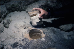
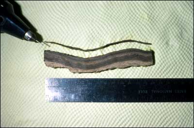
To sample soilstone crust for 14C dates, thin layers are extracted from vertical slices through the crust (Fig. 55). Conventional 14C dates calibrated to correlate with ages derived from precision age-dating methods yielded an age range from 16,505 to 15,405 cal. yr B.P. for the crust overlying the M. annularis at Davis Reef (Table 3). A conventional 14C age of 35,890±720 yr B.P. for the coral was outside calibration range and fell very close to the uncorrected dates from two M. annularis cored from bedrock at Southeast Reef in the Dry Tortugas (34,272±2,146 yr B.P.; Fig. 6A) and near Marker G in the lower Keys (37,480±1,300 yr B.P.; Shinn et al., 1977a). Alteration of aragonite to calcite in these corals biased the 14C dates as being too young.

Lidz et al. (2006) used three types of local evidence to infer the most likely time of accretion of the three misdated corals: (a) late Pleistocene sea-level maxima (highest position was ~9 m below present level, Table 6, Toscano and Lundberg, 1999), (b) the youngest high-precision radiometric date obtained so far for the Pleistocene shelf-edge reef (~77.8 ka, Table 5, Multer et al., 2002), and (c) the oldest radiometric date on a Holocene coral (~9.6 ka, Table 4, Mallinson et al., 2003). All data indicate that sea level between 77.8 and 9.6 ka had remained below elevation of the shelf. The three corals were inferred to belong to the last Pleistocene highstand at ~80 ka that produced the youngest reef framework in the bedrock (Fig. 37A, 37B). Florida corals from that highstand have isotopic ages ranging from 86.2 to 77.8 ka (Toscano, 1996; Multer et al., 2002).

A conventional 14C date of 6,770±210 yr B.P. on the Acropora palmata that overgrew the Davis Reef crust (Fig. 51B; Robbin, 1981) yielded a corrected age range of 7,655 to 6,795 cal. yr B.P. (Table 4), establishing a maximum time of about 7,655 years ago for Holocene reef initiation at Davis Reef. This time is consistent with an older age for the underlying crust, which represents subaerial exposure by the lowered sea level, and with approximate time of flooding of the shelf during the Holocene marine transgression.

Soilstone crust accumulates as wafer-thin layers.
Figure 55. Soilstone crust accumulates as wafer-thin layers. In Florida, normal crust color is white or off-white, like the bottom layers in this specimen. The dark brown and red colors are caused by iron and other non-native minerals derived from airborne African dust that periodically blankets the Florida-Caribbean region (Fig. 5; Muhs et al., 1990; Shinn, 1997; Prospero, 1999; Shinn et al., 2000; Griffin et al., 2001). A dental drill is used to cut individual layers from a crust sample. The crust is sampled every few layers from top to bottom for radiocarbon dating. [larger version]

The top 2 cm of crust at Alligator Reef (water depth 7.2 m) had a corrected age range of 7,979 to 7,500 cal. yr B.P. (Fig. 51A; Table 3; Robbin, 1981). An adjacent mangrove peat sample (water depth 7.2 m) yielded corrected dates of 8,545 to 8,195 cal. yr B.P. The juxtaposition of soilstone crust and mangrove peat indicates irregular surfaces of the underlying bedrock. Crusts can form only on limestone high enough to allow for alternating conditions of wet (rainfall) and dry (recrystallization). Peat tends to accumulate in somewhat lower areas where moisture would be more constant. The slightly older peat in this case is consistent with its formation in a depression that may have been surrounded by accumulating calcrete. The lowermost layers of calcrete were not dated.

Coastal & Marine Geology Program > Center for Coastal & Watershed Studies > Professional Paper 1751

Accessibility FOIA Privacy Policies and Notices

Take Pride in America logo USA.gov logo U.S. Department of the Interior | U.S. Geological Survey
URL: [disc] /pubs/pp/2007/1751/professional-paper/tile2/davis-alligator.html
Page Contact Information: Feedback
Page Last Modified: December 01, 2016 @ 04:13 PM (JSS)