FISC - St. Petersburg
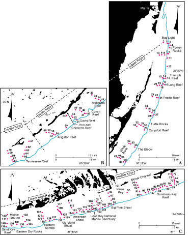
Figure 60. Enlarged insets A-C (from Fig. 59) show numbered 1989 sample sites (red dots of Lidz and Hallock, 2000), relative to the keys (dashed lines), tidal passes, and the shelf margin (blue depth contour, in meters). Note the parallelogram representing the Looe Key National Marine Sanctuary at the margin in (C). Sediment grains illustrated in thin section (Fig. 12) came from the Looe Key National Marine Sanctuary.
|
Can't see the printable PDF version? Get the free Adobe Acrobat® Reader. |

![]() U.S. Department of the Interior |
U.S. Geological Survey
U.S. Department of the Interior |
U.S. Geological Survey
URL: [disc] /pubs/pp/2007/1751/professional-paper/tile3/figures/fig60.html
Page Contact Information: Feedback
Page Last Modified: December 01, 2016 @ 04:13 PM (JSS)
