USGS - science for a changing world

FISC - St. Petersburg

Coastal & Marine Geology Program > Center for Coastal & Watershed Studies > Professional Paper 1751

Systematic Mapping of Bedrock and Habitats along the Florida Reef Tract—Central Key Largo to Halfmoon Shoal (Gulf of Mexico)

USGS Professional Paper 1751

by Barbara H. Lidz, Christopher D. Reich, and Eugene A. Shinn

Introduction:
Table of Contents
Project Overview
Project Objective
Geologic Setting
Primary Datasets
Primary Products - Overview Maps & Evolution Overview:
Bedrock Surface map.
Introduction
Depth to Pleistocene Bedrock Surface
Reef & Sediment Thickness
Benthic Ecosystems & Environments
Sedimentary Grains in 1989
Summary Illustration Index Map
Evolution Overview
Tile-by-Tile Analysis
Satellite image of the Florida Keys showing location of tiles.
Organization of Report
Tiles: 1, 2, 3, 4,
5, 6, 7/8, 9/10,
11
Summary
Acknowledg-
ments
References
Disclaimer
Related
Publications

Tile 5

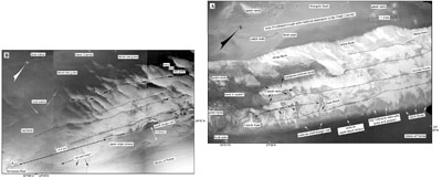
Bands of Outer-Shelf Coral-Rock Ridges: In some areas of the outer shelf, aerial photomosaics clearly show surface expressions of submarine rock ridges separated by sand or seagrass-covered sand within ~3 km landward of the shelf margin (Fig. 78A; Lidz et al., 2003). Some ridges are continuous; others are discontinuous but are defined by isolated hardground exposures (see Benthic Ecosystems for Tile 5). Most ridges can be followed for many kilometers. Some off the upper Keys are sinuous and border depressions filled with seagrass-covered sands (Figs. 33A, 48B, 78A, 78B). Field observations show the sands contain abundant fragments of the staghorn coral Acropora cervicornis (Shinn et al., 2003). Ridges elsewhere on the shelf are less sinuous and are commonly associated with dense sea grasses (Fig. 19).

Benthic Ecosystems for Tile 5
Benthic Ecosystems for Tile 5 [larger version]

Aerial photos (1975) show various sand-body forms in the Florida Keys
Figure 78. Aerial photos (1975) show various sand-body forms in the Florida Keys (from Lidz et al., 2003). Compare with interpreted Benthic Ecosystems for Tile 1 and Tile 3. (A) The backreef marine sand belt of White Bank (Ball, 1967) lines the landward edge of the outer shelf. Note that linear outer-shelf rock ridges (dotted lines) become sinuous around a possible karst or swale depression. Hundreds of patch reefs line the sinuous ridges. Also note numerous sand chutes at the shelf margin and storm-transported reef rubble behind French Reef, Dixie Shoal, and two unnamed reefs located between them. These features lie seaward of Mosquito Bank and its patch reefs, which are located in Hawk Channel on the inner shelf (upper Keys, Fig. 77B). What caused the patch reefs to grow in the channel is a trough within the channel bedrock (Lidz et al., 2006). Patch reefs colonized its landward edge and bedrock highs within the trough. Although a topographic feature, the trough is not discernible in aerial photos as being deeper than other channel areas. This is one of two inner-shelf topographic troughs that constitute newly recognized coral reef nuclei in the Florida reef record (Lidz et al., 2006). The second trough is located in the same inner-shelf position to the southwest (Fig. 75), along the seaward side of the main bedrock depression under Hawk Channel. (B) Seafloor morphology in vicinity of Tennessee Reef (middle Keys, Fig. 77B). Note that an ~4.4-km-wide break or reentrant occurs in the shelf-margin reef in this area. Also note the wide, essentially flat sand-covered upper-slope terrace and the absence of outlier reefs seaward of the reentrant. 'Tripod' symbol represents location of Tennessee Reef Light. Tennessee Reef is composed of Holocene corals that grew on an isolated section of the Pleistocene (~80 ka) shelf-margin reef. The Tennessee Reef high is surrounded by lower bedrock topography that is similar in depth to bedrock in Hawk Channel (see Bedrock Surface map). Dark lines interpreted as rock ridges can be traced along the shelf margin (dotted lines) and at the seaward edge of the upper-slope terrace (arrows). Ovals mark areas of patch reefs on the landward ridge. There is no topographic trough landward of Tennessee Reef other than the main depression under Hawl Channel. [larger version]

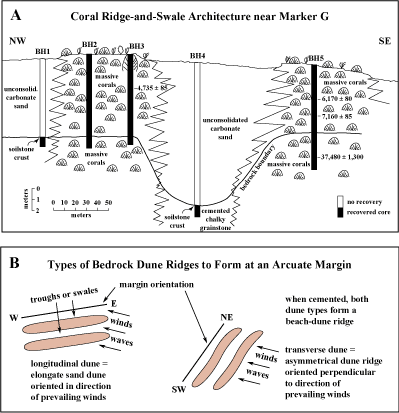
Presence of sea grass is dependent on water depth and clarity. Sea grasses lining only the landward side of a ridge may also indicate local scour along the seaward side by currents or storms. Near or within reentrants in the shelf-margin reef, seagrass-free sands surround higher ridge remnants.

At least three very narrow linear bands interpreted to be ridges are also found on the seaward sand-covered upper-slope terrace in ~40 m of water (Fig. 78B). A 5-core transect was drilled across two such ridges near Marker G in the lower Keys (Fig. 77C; Shinn et al., 1977a). Core results showed that Holocene coral reefs grew on narrow bands of pre-Holocene corals and that the bands were separated by a sediment-filled swale (Fig. 79A). Substrates under all the ridges, whether sinuous or linear, are assumed to consist of bedrock highs, most likely corals, but are thought to have initiated on top of beach-dune ridges (Fig. 79B; Lidz, 2004). Coring has shown that beach-dune-ridge nuclei underlie parallel coral ridges seaward of Bal Harbor, Florida, just north of Miami (Shinn et al., 1977a).

(A) Cross section of core transect across two rock ridges inshore from Marker G in the lower Keys. (B) Sketch shows how beach dunes would form along an arcuate margin with energy prevailing from a southeasterly direction.
Figure 79. (A) Cross section of core transect across two rock ridges inshore from Marker G in the lower Keys (from Shinn et al., 1977a). Core recoveries showed the ridges are coralline, grew vertically, and are separated by a sediment-filled swale. Lateral dimensions of the ridge-and-swale architecture are in the tens of meters. Note conventional radiocarbon ages of corals. The 37,480±1,300 age (calendar years before present) obtained on a recrystallized coral was believed to be much too young. True age of the bedrock coral sections is inferred from other types of evidence to date to marine-isotope substage 5a (between ~86 and 75 ka, Fig. 80; Lidz, 2004). (B) Cemented beach-dune ridges are thought to underlie the coral-rock ridges shelf-wide. Sketch shows how beach dunes would form along an arcuate margin with energy prevailing from a southeasterly direction. Dredged sites through coral-rock ridges seaward of Bal Harbor, located north of Miami, have shown the ridges developed on top of sand dunes (Shinn et al., 1977a). [larger version]

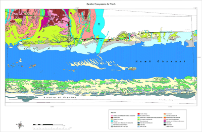
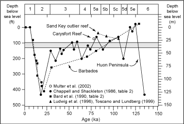
Shelf-wide, most rock ridges harbor patch reefs to varying degrees. Hundreds occupy the upper Keys ridges (Fig. 33A). Fewer populate the middle and lower Keys ridges (Fig. 78B), and only isolated patch reefs occupy ridges nearest the shelf margin. Most patch reefs in the lower Keys are coalesced or densely clustered (Fig. 19; Jones, 1977; Marszalek et al., 1977). Many are found in Hawk Channel, landward of the outer-shelf coral ridges (Lidz et al., 2003, 2006; Fig. 75).

A core from the swale between the two Marker G ridges recovered calcrete (Fig. 7A) on top of chalky, cemented bedrock (Fig. 79A). Presence of calcrete indicates the bedrock surface was exposed to air before Holocene sands accumulated in the swale. Cores through the rock ridges recovered corals. A radiocarbon date obtained on a Montastrea annularis from a ridge depth of 17.1 m below sea level yielded an age of 37,480±1,300 yr B.P., near the outer limit of the radiocarbon-dating method but confirming a pre-Holocene origin (Shinn et al., 1977a). Those authors noted that chemical alteration of the coral had probably biased the date as being much too young, but gave no indication of a true age other than pre-Holocene.

The true age of the altered coral was later inferred from other data to be around 80 ka (Lidz, 2004). In a synthesis of the geologic history of the Florida Keys and reefs over the past 325 ka, Lidz (2004) evaluated all available information on positions of sea level in Florida and on high-resolution radiometric ages of pre-Holocene corals in contact with Holocene accretions. Without exception, all corals on which Holocene reefs or sands developed have so far been dated to within a range of ~86.2 to 77.8 ka (e.g., Toscano, 1996; Multer et al., 2002). This age range corresponds to the highstand of sea level at ~80 ka, or marine-isotope substage 5a (Fig. 80, Table 5). Substage 5a ranges from ~86 to 75 ka.

Graph shows paleotemperature curves for marine-isotope Stages 6-1 developed from global proxy oxygen-isotope records and coral-age data
Figure 80. Graph shows paleotemperature curves for marine-isotope Stages 6-1 developed from global proxy oxygen-isotope records and coral-age data (modified from Ludwig et al., 1996). Stage 5 time is divided into substages 5e-5a. The paleotemperature curves equate to periods of high and low sea levels. Note that sea-level maxima (highest positions) since the substage-5e highstand have not been as high as present sea level. Also note that the standard curve for Barbados (Windward Islands) shows general agreement with data from elsewhere though the Barbados curve is less detailed. The Key Largo Limestone reef (middle and upper Keys) belongs to substage 5e. Corals at various sites along the shelf margin and from the Carysfort (Fig. 35, 36A) and Sand Key (Fig. 18) outlier reefs have been dated to substages 5c, 5b, and 5a (Ludwig et al., 1996; Toscano, 1996; Toscano and Lundberg, 1998, 1999; Multer et al., 2002). Shading represents shelf-wide upper-slope terrace depths (30-40 m) below present sea level. The curves indicate that sea level remained below elevation of the Florida shelf between substage 5a and the Holocene. Lack of Florida corals dating to that period confirms platform exposure from ~77.8 ka (Multer et al., 2002) to ~9.6 ka (Mallinson et al., 2003). [larger version]

No Pleistocene coral younger than 77.8 ka (Multer et al., 2002) has been found on the Florida shelf. The oldest radiometric age on a Holocene coral is 9.6 ka (Table 4; Mallinson et al., 2003). Lack of corals dating between ~77.8 and 9.6 ka, combined with many other lines of evidence, indicates that sea level remained below the elevation of the shelf during that period of time, i.e., for ~68,000 years (Fig. 80; e.g., Toscano, 1996; Lidz, 2004).

Judging from the stacked nature of the coral ridges at Marker G, an older layer of corals, or a beach dune, probably underlies the recovered pre-Holocene sections. Older corals, most likely in the range of 94.4 to 90.6 ka, are suspected (Table 5). Sea-level maxima in Florida would have been sufficient for coral growth at Marker G during highstands at 106, 90, and 80 ka (Toscano and Lundberg, 1999).

Coastal & Marine Geology Program > Center for Coastal & Watershed Studies > Professional Paper 1751

Accessibility FOIA Privacy Policies and Notices

Take Pride in America logo USA.gov logo U.S. Department of the Interior | U.S. Geological Survey
URL: [disc] /pubs/pp/2007/1751/professional-paper/tile5/coral-rock-ridges.html
Page Contact Information: Feedback
Page Last Modified: December 01, 2016 @ 04:14 PM (JSS)