Skip Links

USGS - science for a changing world

Scientific Investigations Map 3324
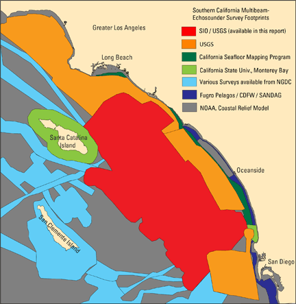
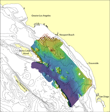
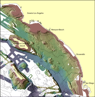
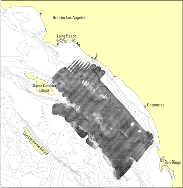
Prepared in cooperation with Scripps Institution of Oceanography

Colored Shaded-Relief Bathymetry, Acoustic Backscatter, and Selected Perspective Views of the Inner Continental Borderland, Southern California

By Peter Dartnell, Neal W. Driscoll, Danny Brothers, James E. Conrad, Jared Kluesner, Graham Kent, and Brian Andrews

Data Catalog

This data catalog contains the multibeam bathymetry and acoustic-backscatter data that comprises the Colored Shaded Relief Bathymetry and Acoustic Backscatter maps of the Inner Continental Borderland, Southern California. This catalog includes data collected in 2013 by Scripps Institution of Oceanography (SIO)(MV-1316) and processed by the U.S. Geological Survey, Pacific Coastal and Marine Science Center. The bathymetry data were merged with publically available multibeam-bathymetry data acquired by federal and local agencies, academic institutions, and private firms (see below for data sources). Also available is a regional perspective view of the inner continental borderland created using the bathymetry data in this report.

The tables below provide the recently collected bathymetry and acoustic-backscatter data in several formats as well as the merged bathymetry of the inner continental borderland. To view an overview map, click on the "Quick View" links. Bathymetry data are available in ASCIIRaster format files and shaded-relief bathymetry geoTIFF images. Acoustic-backscatter images are available as geoTIFF images.

NOTE THAT THE USGS IS PROVIDING THE BATHYMETRIC DATA FOR SCIENTIFIC PURPOSES ONLY. THE USGS DOES NOT GUARANTEE THAT FULL BOTTOM SEARCH HAS BEEN ACHIEVED AND THE DATA HAVE NOT BEEN INSPECTED FOR DANGERS TO NAVIGATION. THESE DATA ARE NOT INTENDED FOR NAVIGATION.

Bathymetry data available to download

File Explanation Bathymetry data in ASCIIRaster format Shaded Relief in geoTIFF format Quick View Metadata
25-m SIO / USGS bathymetry
(WGS-84, MLLW)
MV1316_25mbathy (31 Mb) MV1316_25mshd (4 kb) MV1316_bathy_map TEXT, HTML, FAQ, XML
Merged 25-m inner continental borderland bathymetry
(NAD-83, NAVD-88)
S_CA_25mbathy(60 Mb) S_CA_25mshd(11Mb) S_CA_bathy_map TEXT, HTML, FAQ, XML


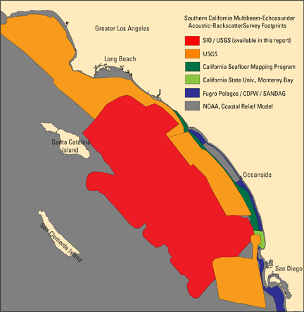
Backscatter data available to download

File Name Backscatter in geoTIFF format Quick View Metadata
25-m SIO / USGS backscater
(WGS-84)
MV1316_backscatter (984Kb) backscatter_map TEXT, HTML, FAQ, XML


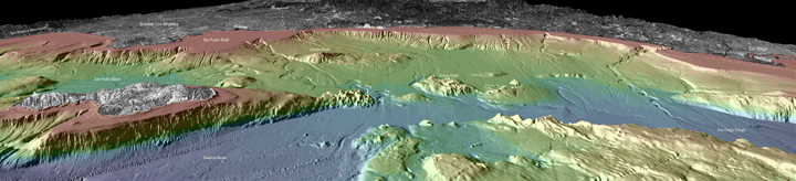
Regional Perspective View

perspective view
Download Full Resolution Image (20 x 4.5 inches at 300 DPI) (15 Mb compressed, 25 Mb uncompressed)
Regional perspective view looking northeast across the inner continental borderland, Southern California. Image created using the multibeam bathymetry data available in this report.


Sources of publically available multibeam bathymetry and acoustic backscatter data used in the Colored Shaded Relief Bathymety and Acoustic Backscatter maps of the Inner Continental Borderland, Southern California.

Bathymetry Sources

bathymetry survey footprints

Backscatter Sources

backscatter survey footprints

USGS Surveys (orange regions):
Los Angeles Margin: https://pubs.usgs.gov/of/2002/0162/
San Diego Margin: https://pubs.usgs.gov/of/2004/1221/
Gulf of Santa Catalina: https://dx.doi.org/10.3133/ofr20141094

California Seafloor Mapping Program and California State University, Monterey Bay Seafloor Mapping Lab (green regions):
http://seafloor.otterlabs.org/csmp/csmp.html
Santa Catalina Island
H11879
H11880
H11881
La Jolla Canyon
San Elijo Lagoon
Santa Margarita River

National Geophysical Data Center (cyan regions):
http://www.ngdc.noaa.gov/mgg/bathymetry/relief.html
CALF01RR
DRFT01RR
GLOR00MV
MCD0212
AT03149
WEST15MV
NPAL

Fugro Pelagos / CDFW / SANDDAG / (dark blue regions): ftp://ftp.dfg.ca.gov/R7_MR/BATHYMETRY/BAT_SCSR_SANDAG.zip

The seafloor within this map that has not been mapped with multibeam echosounders (gray region) is filled in with NOAA’s Coastal Relief Model available at http://www.ngdc.noaa.gov/mgg/bathymetry/relief.html.

USGS Surveys (orange regions):
Los Angeles Margin: https://pubs.usgs.gov/of/2002/0162/l
San Diego Margin: https://pubs.usgs.gov/of/2004/1221/
Gulf of Santa Catalina: http://pubs.er.usgs.gov/publication/ofr20141094

California Seafloor Mapping Program and California State
University, Monterey Bay Seafloor Mapping Lab (green regions):
http://seafloor.otterlabs.org/csmp/csmp.html
H11879
H11880
H11881
San Elijo Lagoon
Santa Margarita River

Fugro Pelagos / CDFW / SANDDAG / (dark blue regions):
ftp://ftp.dfg.ca.gov/R7_MR/BATHYMETRY/BAT_SCSR_SANDAG.zip

For more information contact: Peter Dartnell

First posted April 28, 2015

For additional information, contact:
Pacific Coastal and Marine Science Center
U.S. Geological Survey
Pacific Science Center
400 Natural Bridges Drive
Santa Cruz, CA 95060
http://walrus.wr.usgs.gov/

Part or all of this report is presented in Portable Document Format (PDF). For best results viewing and printing PDF documents, it is recommended that you download the documents to your computer and open them with Adobe Reader. PDF documents opened from your browser may not display or print as intended. Download the latest version of Adobe Reader, free of charge. More information about viewing, downloading, and printing report files can be found here.


Accessibility FOIA Privacy Policies and Notices

Take Pride in America logo USA.gov logo U.S. Department of the Interior | U.S. Geological Survey
URL: http://pubsdata.usgs.gov/pubs/sim/3324/downloads/sim3324_data.html
Page Contact Information: GS Pubs Web Contact
Page Last Modified: Thursday, 01-Dec-2016 17:32:39 EST