Scientific Investigations Report 2007–5157
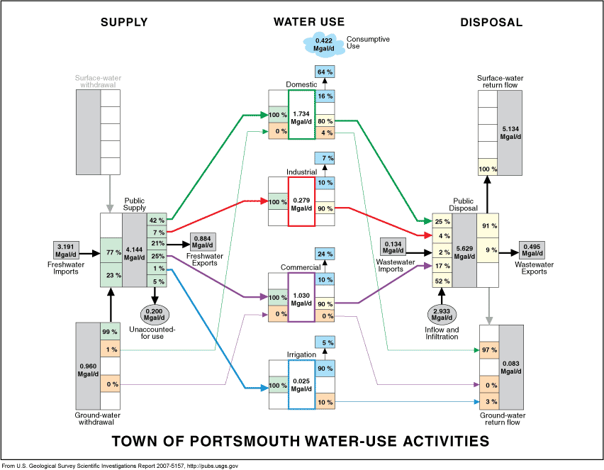
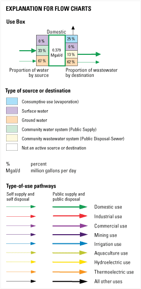
The flow chart of water-use activities is a summary of water withdrawal, public supply, demand, consumptive use, public disposal, and return flow for each town. The flow chart discussed in this explanation is for the City of Portsmouth, and the values in parentheses correspond to the values for Portsmouth. On the left side of the flow chart, information on sources of supply is summarized; water is withdrawn from surface-water or ground-water sources and supplied directly to the user (self supply) or supplied through a community water system (public supply). In the middle section of the flow chart, information on water demand is displayed in four or more boxes to summarize each category of use (domestic, industrial, commercial, irrigation, and occasionally other categories). On the right side of the flow chart, information on wastewater is summarized; wastewater is released to sewers (public disposal) or returned by users to ground water or surface water.
The arrows represent conveyance of water from supply to demand to disposal. The arrows are color-coded to match the category of use and are drawn in two widths. The thick arrows represent public supply or public disposal, and the thin arrows represent self supply or self disposal. The four corners of the flow chart show the town's totals for surface- or ground-water supply source or disposal destination in gray, vertical boxes (none for surface-water withdrawal, 0.960 Mgal/d for ground-water withdrawal, 5.134 Mgal/d for surface-water return flow, and 0.083 Mgal/d for ground-water return flow). These boxes may be connected to a water-use category directly with a thin arrow or through the public supply or public disposal box with a thick arrow. Percentages listed on the left side of any vertical box break the total amount of water into the proportion of its supply sources, and the percentages listed on the right side break the total into the proportion of its disposal destinations. All percentages are rounded to the nearest whole number. A white box indicates that no water of that type is conveyed. A percentage of “0” indicates that the amount of water conveyed is less than 1 percent of the total.
The percentages may not total 100 due to independent rounding. Multiplication of values in million gallons per day by rounded percentages will not result in accurate values. Please consult the town tables for specific values. The public-supply box in the left middle part of the flow chart provides information on water imported into the town (3.191 Mgal/d) and exported from the town (0.884 Mgal/d). The total volume of water for public supply in the town (4.144 Mgal/d) is divided on the left side of the box into the percentages either withdrawn from ground water (23 percent) or surface water (none), or imported into the town (77 percent). The total volume of water for public supply is also divided on the right side of the box into the percentages delivered to domestic (42 percent), industrial (7 percent), commercial (25 percent), and irrigation (1 percent) users; exported (21 percent); and unaccounted-for (5 percent). The public-disposal box in the right middle part of the flow chart provides information on wastewater imported into the town for treatment (0.134 Mgal/d) and exported from the town for treatment and return elsewhere (0.495 Mgal/d). The total volume of wastewater treated (5.629 Mgal/d) is divided on the left side of the box into the percentages released from domestic (25 percent), industrial (4 percent), and commercial (17 percent) users; imported (2 percent); and added to the system through inflow and infiltration (52 percent). The total volume of publicly disposed water is also divided on the right side of the box into the percentages of wastewater either treated and returned to surface water (91 percent) or ground water (none), or sent to another town for treatment (9 percent). In the middle part of the flow chart, sources of supply and destinations of wastewater for four major categories of water use are summarized—domestic, commercial, industrial, and irrigation. Each category of use is indicated by a colored frame around its vertical box and matching colored arrows (for example, green for domestic use) showing the paths from supply and to disposal. Information on the sources of supply is provided on the left side of each use box. For example, almost 100% of water used for domestic purposes in Portsmouth is publicly supplied; none is self-supplied surface water; and less than 1% comes from private ground-water wells. Information on wastewater destinations is provided on the right side. In Portsmouth, 4% of water used for domestic purposes is discharged to ground water through septic systems; none is discharged directly to surface water; and 80% is returned via public sewers. The flow chart also includes an estimate of consumptive use for each type of user (16 percent for domestic use in Portsmouth). Consumptive use (water that is used but not returned to the hydrologic system because it has been evaporated or incorporated in a product like bottled water or beer) is summarized in the upper middle part of the flow chart (0.422 Mgal/d) within the blue cloud. Above and to the right of each use box is the percentage that its category's consumptive use contributes to total consumptive use. For example, domestic consumptive use contributes 64 percent to total consumptive use.
| |||||||||||||||||||||||

![]() U.S. Department of the Interior |
U.S. Geological Survey
U.S. Department of the Interior |
U.S. Geological Survey
URL: https://pubs.usgs.gov/sir/2007/5157/charts.htm
Page Contact Information: Laura Hayes, Marilee Horn
Page Last Modified: 25-March-08, 16:00:00 EDT
