| Surface water contributes approximately 75 percent of the City of Cheyenne's public water supply. The water is collected from the Douglas Creek and Crow Creek drainage areas. Most of the water is stored in four reservoirs located in southeastern Wyoming-Rob Roy, Lake Owen, Granite Springs, and Crystal Lake (fig. 1). Water flows through the reservoir system via a series of pipelines and stream channels. At Crystal Lake Reservoir, the water is diverted into pipelines and routed to the public water-treatment facilities. The entire water collection, treatment, and distribution system is operated by the Cheyenne Board of Public Utilities (BOPU). | 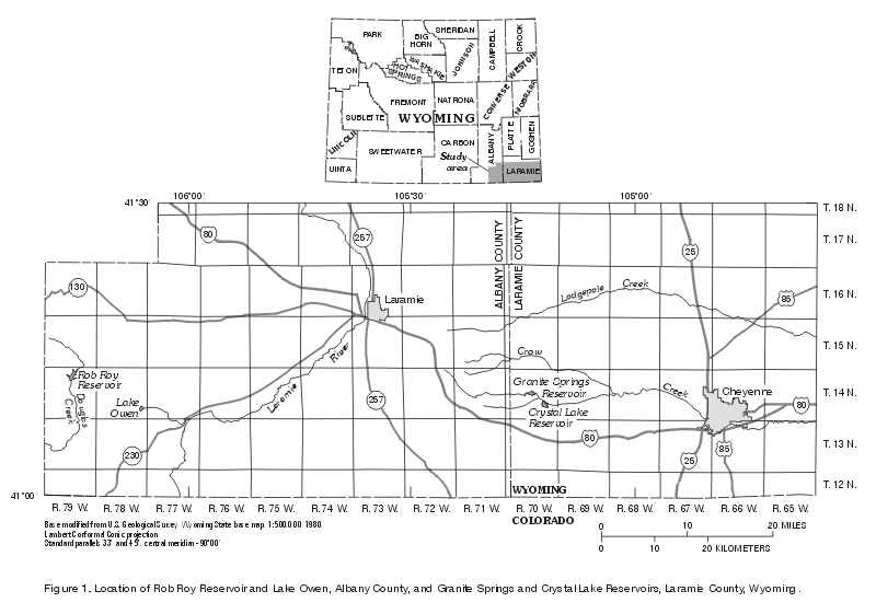
Figure 1. Location of Rob Roy Reservoir and Lake Owen, Albany
County, and Granite Springs and Crystal Lakes Reservoirs, Laramie
County, Wyoming. |
Although extensive water-quality data have been collected for the treated water, relatively limited data are available for the raw-water quality within the storage reservoirs. Data on the water quality in the reservoirs are needed to assist BOPU managers for future planning of the Cheyenne water system. In order to meet those needs, a study was conducted during 1997-98 by the BOPU and the U.S. Geological Survey (USGS). Data on the reservoir water quality collected during the study will assist the BOPU in evaluating reservoir and watershed management options in conjunction with treatment options.
This report provides baseline water-quality data for four reservoirs-Rob Roy, Lake Owen, Granite Springs, and Crystal Lake. Specifically this report summarizes phytoplankton and profile data collected at a selected monitoring site in each reservoir over a summer season, selected physical, chemical and biological constituents for a single sample collected from the water column during the summer of 1997, and selected chemical constituents in composite samples of bottom sediment from each reservoir. The report is limited to the four reservoirs and to a general description of the water quality of the reservoirs. Lake processes are not examined. Due to unexpected opportunities, the project team was able to add winter, spring, and summer profiles for Granite Springs and Crystal Lake Reservoirs.
Surface water for the City of Cheyenne's public-water system is collected in reservoirs, two of which-Rob Roy and Lake Owen-are about 80 miles west of Cheyenne (fig. 1). Most diversion facilities and a delivery pipeline were constructed in the 1960s. These facilities were designed and constructed to divert water from the Douglas Creek drainage (fig. 2A) to provide Cheyenne with a long-term surface-water supply. The original construction was referred to as Stage I. Stage II was constructed in 1985 and consisted of improvements to the dams as well as construction of a parallel pipeline from Rob Roy Reservoir to Crystal Lake Reservoir.
The Cheyenne water-treatment facilities receive raw water directly from Crystal Lake Reservoir, located in the Middle Crow Creek drainage (fig. 2D). The average annual yield from Middle Crow Creek drainage, which includes Granite Springs and Crystal Lake, is estimated to be about 1.23 billion gallons. The 1998 annual treated-water demand was approximately 4.5 billion gallons. Of this total, about 1 billion gallons of treated water is supplied by ground water and the remainder is supplied by surface water. To meet the current and future treated-water demands of the community, yield from the Stage I and Stage II projects is required. This will include the average annual divertable flow from the Douglas Creek drainage of about 6.8 billion gallons.
 |
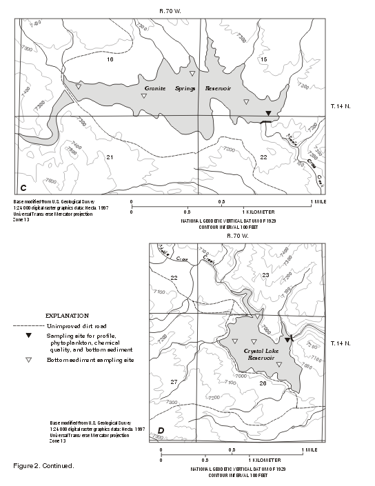 |
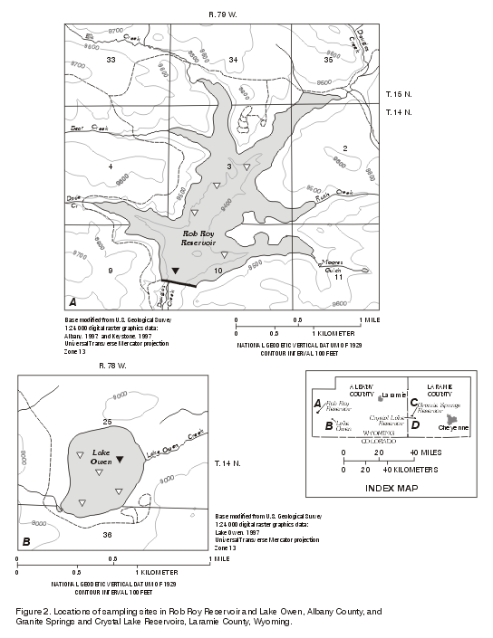
| Figure 2A, 2B, 2C, and 2D. Location of sampling sites in Rob Roy Reservoir and Lake Owen, Albany County, and Granite Springs and Crystal Lake Reservoirs, Laramie County, Wyoming. (Click on images for larger versions; left, 51kb; right, 59kb) | |
The study area (fig. 1) is the four reservoirs-Rob Roy, Lake Owen, Granite Springs, and Crystal Lake. The reservoir system begins with Rob Roy Reservoir located in the Douglas Creek drainage. Runoff is collected and stored in Rob Roy Reservoir (fig. 2A). BOPU diverts stored water from Rob Roy by a pipeline to Lake Owen (fig. 2B). From Lake Owen, water is transported, again by pipeline to the Middle Crow Creek drainage (fig. 2C).
Within the Middle Crow Creek drainage, water is stored in two reservoirs-Granite Springs and Crystal Lake. Granite Springs provides 1.7 billion gallons of storage and Crystal Lake provides 1.1 billion gallons. Water within the Middle Crow Creek drainage is routed from Granite Springs down Middle Crow Creek and also by pipeline to Crystal Lake. From Crystal Lake, water is transported by pipelines and Middle Crow Creek to the water treatment facilities. Selected characteristics of the four reservoirs are summarized in table 1.
Table 1. Selected reservoir characteristics for Rob Roy Reservoir and Lake Owen, Albany County, and Granite Springs and Crystal Lake Reservoirs, Laramie County, Wyoming
[Elevation and storage data provided by Cheyenne Board of Public Utilities]
|
Reservoir |
Approximate |
Approximate |
Approximate |
Percent of |
|---|---|---|---|---|
|
Rob Roy |
9,470 |
11.4 |
80 |
79 |
|
Lake Owen |
8,955 |
.2 |
10 |
1 |
|
Granite Springs |
7,210 |
1.7 |
60 |
12 |
|
Crystal Lake |
6,969 |
1.1 |
65 |
8 |
The Cheyenne BOPU and many BOPU employees have contributed to making this project a success. The sampling assistance of Kay Knott, Marv Tripp, Jason Haughton, and Deb Streetman is gratefully acknowledged. Tim Wilson's continuing support and Herman Noe's help in collecting information about the reservoirs are appreciated. Jerry Mark and Jack Carroccia were instrumental in initiating the study.
The sampling sites in each reservoir were located at or near the deepest point, to reflect integrated water quality to the extent possible (fig. 2A, B, C, D). Three types of sampling were completed at each reservoir: (1) depth profiles of temperature, dissolved oxygen, specific conductance, and pH, and sampling of phytoplankton, (2) a one-time sampling for chemical quality, and (3) a composite bottom-sediment sample. Profile measurements and phytoplankton samples were collected once in the late summer of 1997 and approximately every two weeks in the summer of 1998 at all four reservoirs.
The reservoirs were vertically profiled from about 1 foot below the water surface to the bottom of the lake in a location estimated to have the greatest depth, based on examination of maps and initial sounding of depths. During late summer of 1997, all four reservoirs were profiled. Granite Springs and Crystal Lake Reservoirs also were profiled in February 1998. Rob Roy Reservoir and Lake Owen were not profiled in the winter due to accessibility problems and dangerous ice conditions. Profile data for Granite Springs and Crystal Lake Reservoirs were collected from mid-May until mid-July of 1998. Beginning in mid-July, profiles were completed at all four reservoirs until late summer of 1998. The data were measured with HydroLab Scout II and YSI 6920 multi-parameter probes. Data collected were temperature, dissolved oxygen, specific conductance, and pH. Individual probes were calibrated before profiling, and the two multiparameter-probes were compared to each other in the field at random times. Readings of the two instruments were comparable with temperature differences between 0.1 and 0.15 degrees, dissolved-oxygen differences between 0.02 and 0.5 mg/L (milligrams per liter), and pH differences from 0.06 to 0.2. Specific conductance had the largest differences between probes varying from 2.6 µS/cm (microsiemens per centimeter at 25°C) to 22.5 µS/cm. The same profile pattern was obtained with both instruments. No adjustments were made to the data. Secchi disk transparencies were collected at each reservoir.
At the same time as profiling, a sample was collected at a depth of 1 foot below the water surface (hereafter referred to as the surface sample) at each water sampling site for identification and enumeration of phytoplankton. During the sampling for chemical quality in the late summer of 1997, a bottom sample of phytoplankton also was collected at 3 ft (feet) above the reservoir bottom (hereafter referred to as the bottom sample) at Rob Roy, Granite Springs and Crystal Lake Reservoirs. Due to its shallow depth, only a surface sample was collected at Lake Owen. The same nomenclature for surface and bottom samples is used throughout this report for both phytoplankton and chemical-quality samples.
The four reservoirs were sampled once in the fall of 1997 between August 28 and September 11 for chemical analysis of organic and inorganic constituents. Reservoirs were sampled at the same location where the profiles were measured. At each sampling site, water-quality samples were collected at two depths, using a Kemmerer bottle. As described for phytoplankton sampling, a surface sample was collected at a depth of 1 ft below the water surface in the epilimnion. A bottom sample was collected from about 3 ft above the reservoir bottom. Likewise, at Lake Owen, due to its shallow depth and the lack of variability in the profile data, a single surface sample was collected. A third sample was collected at Crystal Lake at 30 ft below the reservoir surface. This depth was estimated to correlate to the pipeline intake level for the water treatment plant. The constituent list included phytoplankton, nutrients, major ions, trace elements, and microscopic particulate analysis (MPA). Additional analyses for selected radio-chemical and pesticide compounds were completed in samples collected from Crystal Lake Reservoir because it is the direct source of the water to the treatment plant. Nutrients, major ions, and trace elements were analyzed at the USGS National Water Quality Laboratory in Arvada, Colorado. The MPA samples were collected by BOPU using the procedure recommended by the U.S. Environmental Protection Agency (1996); the procedure specifies a total collection time of 24 hours from filter installation. The phytoplankton and MPA analyses were performed by CH Diagnostic in Loveland, Colorado. Phytoplankton biomass was calculated from phytoplankton biovolume, assuming a density of one gram per cubic centimeter. Chemical analyses and physical properties of the water samples collected from the four reservoirs are listed in table 2.
Samples of the bottom sediment were collected at five sites in each reservoir (fig. 2) using a Ponar grab sampler. One of the five sites in each reservoir also was the sampling site for profiles, phytoplankton, and chemical quality. Each sample was subsampled to obtain material that had not been in contact with the sides of the sampler. The five samples then were composited into a single sample for each reservoir. If needed, the sample was sieved through a 63-um (micrometer) sieve in preparation for trace-element analysis. Sediment samples were analyzed for trace elements and nutrients at the USGS, Branch of Geochemistry Analytical Services Group Laboratory, Denver, Colorado.
A second sample for replicate phytoplankton analysis was collected from Crystal Lake Reservoir on September 7, 1997. Comparison of the two samples indicated the difference was less than 30 percent for phytoplankton biomass, density, and number of taxa identified. No adjustments were made to the phytoplankton data based on the quality-control sample.
A duplicate sample for chemical analysis was collected when the surface sample was collected at Crystal Lake. Major-ion concentrations agreed closely. Differences in the individual ion concentration between the two samples were less than 0.1 mg/L, except for alkalinity, which varied by 1 mg/L.
Table 2. Chemical analyses and physical properties of water-quality samples collected in 1997 from Rob Roy Reservoir and Lake Owen, Albany County, and Granite Springs and Crystal Lake Reservoirs, Laramie County,
Wyoming
[QA, duplicate sample collected for quality assurance purposes; a, not measured due to the occurrence of a lightning storm; concentrations of copper, lead, boron, aluminum, arsenic, and selenium from Rob Roy Reservoir and Lake Owen should be considered approximate. The initial samples were misplaced at laboratory login. Back-up samples that had been chilled were used for replacements.
µS/cm, microsiemen per centimeter at 25°C; °C, degrees Celsius; mg/L, milligram per liter;
µg/L, microgram per liter]
|
Site |
Identification number |
Date |
Time |
Specific |
pH |
Water |
Color (as platinum- |
Dissolved |
Chemical |
Hardness |
Calcium, |
Magnesium, |
Sodium, |
|---|---|---|---|---|---|---|---|---|---|---|---|---|---|
|
Rob Roy |
411153106154401 |
9/2/97 |
10:40 |
25 |
6.9 |
15.4 |
0 |
6.0 |
11 |
10 |
3.1 |
0.6 |
1.4 |
|
Rob Roy |
411153106154402 |
9/2/97 |
12:15 |
24 |
6.2 |
6.3 |
30 |
6.2 |
11 |
10 |
3.0 |
0.6 |
1.3 |
|
Lake Owen (top) |
410858106060901 |
9/2/97 |
15:40 |
30 |
7.2 |
15.6 |
16 |
6.7 |
11 |
13 |
3.9 |
0.7 |
1.4 |
|
Granite Springs Reservoir (top) |
411031105132501 |
8/28/97 |
13:40 |
95 |
8.0 |
19.9 |
22 |
8.0 |
19 |
40 |
13 |
1.8 |
2.7 |
|
Granite Springs Reservoir |
411031105132502 |
8/28/97 |
15:30 |
101 |
6.7 |
16.0 |
22 |
6.7 |
13 |
43 |
14 |
1.9 |
2.8 |
|
Crystal Lake |
410928105115201 |
9/4/97 |
9:50 |
108 |
8.4 |
18.5 |
12 |
6.3 |
15 |
46 |
15 |
2.3 |
3.0 |
|
Crystal Lake |
410928105115201 |
9/4/97 |
9:55 |
108 |
8.4 |
18.5 |
13 |
6.3 |
16 |
46 |
15 |
2.3 |
3.0 |
|
Crystal Lake |
410928105115203 |
9/11/97 |
13:00 |
a |
a |
a |
12 |
a |
15 |
47 |
15 |
2.3 |
3.0 |
|
Crystal Lake |
410928105115202 |
9/4/97 |
12:00 |
114 |
6.7 |
16.3 |
13 |
<1 |
<10 |
48 |
15 |
2.3 |
3.0 |
|
Site |
Sodium |
Sodium |
Potassium, |
Alkalinity |
Sulfate, |
Chloride, |
Fluoride, |
Silica |
Dissolved |
Residual |
Nitrogen |
Nitrogen, NO2, |
|---|---|---|---|---|---|---|---|---|---|---|---|---|
|
Rob Roy |
22 |
0.2 |
0.4 |
13 |
1.3 |
0.3 |
<0.1 |
4.0 |
19 |
39 |
<0.02 |
<0.01 |
|
Rob Roy |
21 |
0.2 |
0.4 |
12 |
1.4 |
0.3 |
<0.1 |
6.9 |
22 |
45 |
<0.02 |
<0.01 |
|
Lake Owen |
19 |
0.2 |
0.3 |
15 |
1.1 |
0.7 |
<0.1 |
2.5 |
20 |
42 |
<0.02 |
<0.01 |
|
Granite Springs Reservoir (top) |
13 |
0.2 |
1.0 |
40 |
3.4 |
2.4 |
0.3 |
5.8 |
55 |
69 |
0.15 |
<0.01 |
|
Granite Springs Reservoir |
13 |
0.2 |
1.0 |
41 |
3.4 |
2.5 |
0.4 |
8.3 |
59 |
79 |
<0.02 |
<0.01 |
|
Crystal Lake |
12 |
0.2 |
1.1 |
46 |
4.5 |
2.4 |
0.5 |
2.1 |
58 |
80 |
<0.02 |
<0.01 |
|
Crystal Lake |
13 |
0.2 |
1.2 |
46 |
4.4 |
2.6 |
0.5 |
2.1 |
58 |
91 |
<0.02 |
<0.01 |
|
Crystal Lake |
12 |
0.2 |
1.3 |
45 |
4.3 |
2.7 |
0.5 |
3.9 |
60 |
87 |
0.09 |
<0.01 |
|
Crystal Lake |
12 |
0.2 |
1.2 |
44 |
4.4 |
3.4 |
0.5 |
6.4 |
63 |
90 |
0.14 |
<0.01 |
|
Site |
Nitrogen, NO2 + NO3,
dissolved |
Phosphorus |
Oil & grease (total) |
Arsenic, |
Boron, |
Copper, |
Iron, |
Lead, |
Manganese, |
Aluminum, |
Selenium, |
|---|---|---|---|---|---|---|---|---|---|---|---|
|
Rob Roy |
<0.05 |
<0.01 |
<1 |
<1 |
16 |
4 |
51 |
<1 |
2 |
45 |
<1 |
|
Rob Roy |
0.08 |
<0.01 |
2 |
<1 |
17 |
4 |
69 |
<1 |
69 |
123 |
<1 |
|
Lake Owen |
<0.05 |
<0.01 |
<1 |
<1 |
19 |
4 |
130 |
2.3 |
8 |
24 |
<1 |
|
Granite Springs Reservoir (top) |
<0.05 |
<0.01 |
<1 |
<1 |
14 |
4 |
7 |
<1 |
5 |
18 |
<1 |
|
Granite Springs Reservoir |
<0.05 |
<0.01 |
<1 |
<1 |
8.4 |
4 |
21 |
4.1 |
76 |
<5 |
<1 |
|
Crystal Lake |
<0.05 |
<0.01 |
2 |
<1 |
12 |
2 |
10 |
<1 |
<1 |
6.4 |
<1 |
|
Crystal Lake |
<0.05 |
<0.01 |
<1 |
<1 |
<16 |
2 |
13 |
<1 |
<1 |
14.2 |
<1 |
|
Crystal Lake |
<0.05 |
<0.01 |
<1 |
<1 |
18 |
2 |
28 |
<1 |
2 |
8.4 |
<1 |
|
Crystal Lake |
<0.05 |
<0.01 |
<1 |
<1 |
12 |
7 |
24 |
<1 |
31 |
10 |
<1 |
Water in reservoirs often becomes stratified. This zonation of lakes is a reflection of the differences in water density with the warmer, less dense water at the top; a cold dense layer at the bottom; and a zone of rapidly changing density between them. The three zones are the epilimnion (the upper, warmer water), the metalimnion (the middle zone where the rate of change in temperature is the greatest-also sometimes called the thermocline), and the hypolimnion (the lower, colder water). Powell (1964, p. 19-20) states that the metalimnion in natural lakes is often observed between 25 to 40 ft below the surface, but may vary from that depth in artificial impoundments.
Profiles of temperature were examined in all four reservoirs for thermal stratification. As is commonly found in temperate lakes (Horne and Goldman, 1994, p. 53-65), three vertical zones were identified in Rob Roy, Granite Springs, and Crystal Lake Reservoirs at selected times during late summer. Lake Owen's shallow depth precluded such stratification. Temperatures in the reservoirs in this study are influenced by both natural lake processes and pipeline inflow and outflow. That stratification impacts the quality of the impounded water (McGauhey, 1968, p. 92).
Surface-water quality in an impoundment is highly variable on both short and long term cycles (Moore, 1989, p. 30). Reservoirs are dynamic and have a complex interaction of chemistry and biology both seasonally and over decades. Samples collected during this study represent the quality of the water in the reservoirs at that point in time.
Sediment can act as sites for ion exchange between aquatic and solid phases. If elements or compounds are in large concentrations in the water, the sediments may remove them by adsorption. Conversely, if the concentrations are low, the elements or compounds may move from the sediment into the water. Thus, a dynamic equilibrium exists between the sediment and the water. Bottom-sediment samples were collected at all four reservoirs. The sediment-analysis results for each reservoir are summarized in table 3.
Sediment in reservoirs is strongly influenced by the geology of the watershed of the lake. Concentrations of selected constituents in sediment from the reservoirs were compared to published values for diabase (diorite), crustal averages, and granitic rocks (Mason, 1966) to give a perspective on the concentration.
Table 3. Chemical analyses of composite samples of
bottom sediment collected in 1998 from Rob Roy Reservoir and Lake Owen, Albany
County, and Granite Springs and Crystal Lake Reservoirs, Laramie County, Wyoming
[Except for nitrogen, all results are for
sediment passing through a 63 µm sieve; µg/g, microgram per gram]
|
Site |
Date sampled |
Nitrogen, |
Aluminum |
Arsenic |
Barium |
Beryllium (µg/g) |
Bismuth (µg/g) |
Cadmium |
Calcium |
Cerium |
Chromium |
Cobalt |
|---|---|---|---|---|---|---|---|---|---|---|---|---|
|
Rob Roy |
7/23/98 |
9 |
6.9 |
<10 |
690 |
2 |
<10 |
<2 |
1.0 |
58 |
53 |
13 |
|
Lake Owen |
7/23/98 |
8 |
6.9 |
<10 |
520 |
1 |
<10 |
<2 |
2.2 |
50 |
120 |
16 |
|
Granite Springs Reservoir |
2/5/98 |
<2 |
6.2 |
<10 |
830 |
2 |
<10 |
<2 |
.65 |
130 |
12 |
5 |
|
Crystal Lake Reservoir |
2/3/98 |
<2 |
6.8 |
<10 |
720 |
3 |
<10 |
<2 |
.90 |
200 |
21 |
7 |
|
Site |
Date |
Copper |
Europium |
Gallium (µg/g) |
Gold |
Holmium |
Iron |
Lanthanum |
Lead |
Lithium (µg/g) |
Magnesium |
Manganese |
|---|---|---|---|---|---|---|---|---|---|---|---|---|
|
Rob Roy |
7/23/98 |
43 |
<2 |
14 |
<8 |
<4 |
3.1 |
35 |
19 |
36 |
.89 |
800 |
|
Lake Owen |
7/23/98 |
58 |
<2 |
13 |
<8 |
<4 |
2.7 |
30 |
16 |
29 |
1.4 |
470 |
|
Granite Springs Reservoir |
2/5/98 |
77 |
<2 |
17 |
<8 |
<4 |
2.2 |
82 |
28 |
15 |
.34 |
290 |
|
Crystal Lake Reservoir |
2/3/98 |
150 |
2 |
20 |
<8 |
<4 |
3.6 |
120 |
31 |
20 |
.71 |
460 |
|
Site |
Date |
Mercury |
Molybdenum |
Neodymium |
Nickel |
Niobium |
Phosphorus |
Potassium |
Scandium |
Selenium |
Silver |
Sodium |
|---|---|---|---|---|---|---|---|---|---|---|---|---|
|
Rob Roy |
7/23/98 |
.05 |
<2 |
27 |
25 |
16 |
.080 |
1.8 |
10 |
0.4 |
<2 |
1.1 |
|
Lake Owen |
7/23/98 |
.04 |
<2 |
26 |
52 |
13 |
.050 |
1.3 |
14 |
0.9 |
<2 |
.84 |
|
Granite Springs Reservoir |
2/5/98 |
.02 |
<2 |
63 |
8 |
22 |
.050 |
3.3 |
6 |
0.4 |
<2 |
1.7 |
|
Crystal Lake Reservoir |
2/3/98 |
.03 |
<2 |
93 |
14 |
29 |
.080 |
2.7 |
10 |
0.6 |
<2 |
1.3 |
|
Site |
Date |
Strontium |
Sulfur |
Tantalum |
Thorium |
Tin |
Titanium |
Uranium |
Vanadium |
Yttrium |
Ytterbium |
Zinc |
|---|---|---|---|---|---|---|---|---|---|---|---|---|
|
Rob Roy |
7/23/98 |
160 |
.05 |
<40 |
8 |
<5 |
.32 |
<100 |
87 |
17 |
1 |
96 |
|
Lake Owen |
7/23/98 |
220 |
.24 |
<40 |
7 |
<5 |
.23 |
<100 |
110 |
16 |
1 |
71 |
|
Granite Springs Reservoir |
2/5/98 |
130 |
<.05 |
<40 |
21 |
<5 |
.19 |
<100 |
29 |
31 |
3 |
66 |
|
Crystal Lake Reservoir |
2/3/98 |
120 |
.07 |
<40 |
31 |
<5 |
.31 |
<100 |
46 |
49 |
5 |
99 |
[Table of Contents] [Abstract]
[Introduction]
[Rob Roy Reservoir]
[Lake Owen]
[Granite Springs
Reservoir] [Crystal Lake Reservoir]
[Summary]
[Appendix A]
[Appendix B]