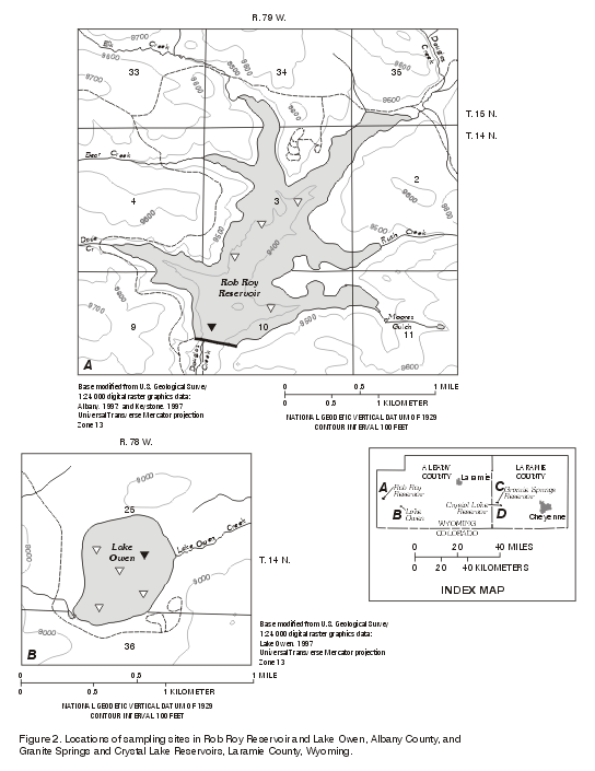
Rob Roy Reservoir is the largest, deepest, and highest in the series of the reservoirs (fig. 2A; table 1). It contains 79 percent of the storage capacity of the four-reservoir system. At the profiling site, the reservoir was about 80-ft deep. The spillway elevation is 9,470 ft above sea level (table 1). Rob Roy is located in a mountainous area surrounded by evergreen forest. The lake and surrounding area are the focus of recreational activities, such as boating, fishing and camping. Rob Roy is the only reservoir of the four that receives runoff only from its watershed and receives no inflow from other reservoirs.
| Profile measurements indicated that Rob Roy was stratified from mid-July to late September 1998. Stratification is shown in a profile measured September 2, 1997 (fig. 3A). The temperature, dissolved oxygen, specific conductance, and pH profiles were relatively constant in the epilimnion, from about 1 ft below the surface to about 11 ft. The temperature decreased at a steady rate, from about 15°C (degrees Celsius) at 11 ft, to about 6°C at about 65 ft below the surface. The pH also gradually decreased, from 6.9 at about 8 ft to 6.2 at about 55 ft. The Secchi disk transparency was 9.8 ft, which was the deepest transparency recorded during the summer 1997 sampling trips. In many lakes the Secchi depth is approximately one-third the depth of the euphotic zone (Horne and Goldman, 1994, p. 34); therefore, the euphotic zone was estimated to extend to about 29 ft below the surface, which is also where dissolved-oxygen concentrations decrease about 1 mg/L. | 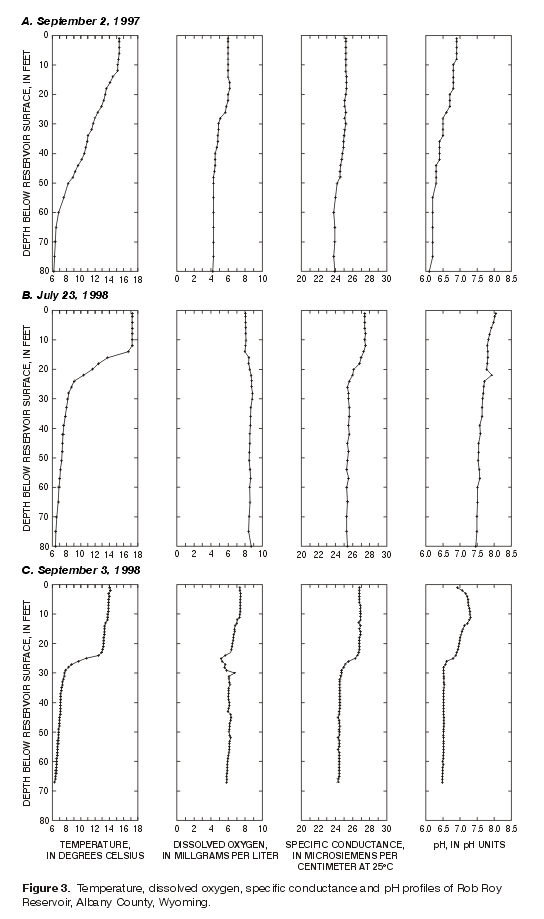
Figure 3. Temperature, dissolved oxygen, specific conductance, and pH profiles of Rob Roy Reservoir, Albany County, Wyoming (Click on image for a larger version, 39kb) |
| Likewise, the July 23, 1998 profiles of Rob Roy (fig. 3B) show stratification of the water column in the reservoir. The temperature, dissolved oxygen, specific conductance, and pH profiles were relatively constant from the surface to about 13 ft. The temperature decreased with depth at a fairly steady rate, from about 17°C at 13 ft, to about 8.5°C at about 27 ft in the metalimnion. Within about that same interval, dissolved oxygen increased and specific conductance decreased. The Secchi disk transparency on July 21 was 12.5 ft (fig. 4), yielding an estimated euphotic zone of about 38 ft. | 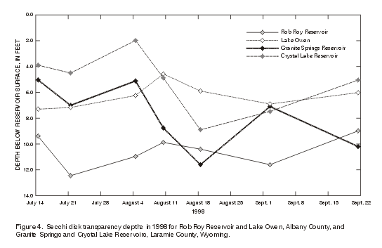
Figure 4. Secchi disk transparency depths in 1998 for Rob Roy
Reservoir and Lake Owen, Albany County, and Granite Springs and Crystal
Lake Reservoir, Laramie County, Wyoming. |
The September 3, 1998 profiles of Rob Roy (fig. 3C) were similar to the September 2, 1997 profiles; however, the most noticeable change was the increased thickness of the epilimnion and the decreased thickness of the metalimnion in 1998. The temperature, dissolved oxygen, and specific conductance were relatively constant from the surface to about 24 ft in depth. The temperature ranged from about 15°C to 14°C in the upper 24 ft, then sharply decreased to about 8.2°C at 29 ft. Temperature then gradually decreased from about 8.2 to 6.4°C at 67 ft. The pH increased from 6.9 at the surface to 7.3 at 12 ft and then decreased to 6.5 at 28 ft. The pH remained relatively constant from 28 ft to 67 ft. Dissolved-oxygen concentrations varied from 7.4 mg/L at the surface to 5.9 mg/L at 67 ft. A zone of slightly lower dissolved oxygen was present from 24 to 29 ft. The Secchi disk transparency was 11.6 ft, with the estimated euphotic zone extending to about 35 ft. Additional profiles for 1998 are included in appendix A.
| The profiles indicate that the depth of stratification in Rob Roy changed over time in 1998. When the seasonal variations of temperature in the summer and fall of 1998 are examined (fig. 5), two characteristics of Rob Roy are apparent. The first is that a strong stratification developed by mid-July and continued until September; by early October, the reservoir was no longer stratified. The second is that the zone of warming in the reservoir extended deeper into the reservoir from mid-July to late September 1998. The 10°C temperature contour line dropped from about 20 ft in mid-July to about 30 ft by late September. The zone continued to deepen after surface cooling began in early September. | 
Figure 5. Temporal variation of temperature with depth in Rob Roy
Reservoir, Albany County, Wyoming, in summer and fall, 1998. |
| Bacillariophyta (diatoms) and Chlorophyta (green algae) dominated the phytoplankton community of Rob Roy. The diatoms, in terms of biomass (mass of the phytoplankton cells), dominated the samples collected during September 1997 and August 1998 (fig. 6). The data shown in figure 6 are from samples collected at a depth of 1 ft below the surface, at a site near the deepest part of the reservoir (fig. 2A). An abrupt shift in the phytoplankton community from diatoms to green algae was evident in the September 1998 samples. Other algae identified in the samples included the Cryptophyta (cryptomonads), the Pyrrophyta (dinoflagellates), and the Chrysophyta (golden-brown algae). Euglenophyta (euglenoids) and Cyanophyta (blue-green algae), which are often associated with organic or nutrient enrichment, were absent from the samples. Phytoplankton taxa are listed in table 4. The complete phytoplankton data set for all four reservoirs are listed in Appendix B; data for Rob Roy are listed in table B1 of Appendix B. | 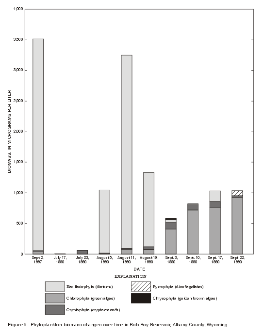
Figure 6. Phytoplankton biomass changes over time in Rob Roy Reservoir, Albany County, Wyoming. |
Twenty-nine taxa of algae were identified from the samples (table 4). Two species of diatoms, Asterionella and Fragilaria, were responsible for the predominance of diatoms in the September 1997 and August 1998 samples. The maximum biomass of Asterionella was 3,500 µg/L (micrograms per liter), which constituted 98 percent of the total phytoplankton biomass in the September 1997 sample. The corresponding density of Asterionella in that sample was 2,590 cells per milliliter (cells/mL). Asterionella and Fragilaria were codominant species during August 1998. The maximum concentration of Fragilaria was 1,700 µg/L biomass (1,550 cells/mL density) in the August 11 sample.
Table 4. Phytoplankton taxa list for Rob Roy
Reservoir and Lake Owen, Albany County, and Granite Springs and Crystal Lake
Reservoirs, Laramie County, Wyoming
[x indicates taxa presence]
|
Phytoplankton taxa |
Reservoir |
|||
|---|---|---|---|---|
|
Rob Roy |
Lake Owen |
Granite Springs |
Crystal Lake |
|
|
BACILLARIOPHYTA (Diatoms) |
|
|
|
|
|
Centrales (Centric diatoms) |
|
|
|
|
|
Centrales size 1 |
|
x |
x |
|
|
Centrales size 2 |
|
x |
x |
|
|
Centrales size 3 |
|
x |
x |
|
|
Centrales size 4 |
|
x |
|
|
|
Cyclotella |
|
x |
x |
|
|
Melosira |
|
|
x |
|
|
Melosira size 1 |
|
x |
|
|
|
Melosira size 2 |
|
x |
||
|
Melosira size 3 |
|
x |
||
|
Stephanodiscus |
|
x |
x |
|
|
Pennales (Pennate diatoms) |
|
|
|
|
|
Achnanthes |
x |
x |
||
|
Asterionella |
x |
x |
x |
|
|
Cymbella |
|
x |
||
| Fragilaria |
x |
x |
x |
x |
|
Nitzschia |
x |
|
|
|
|
Pennales size 1 |
|
|
x |
|
|
Pennales size 2 |
|
x |
x |
|
|
Pennales size 3 |
|
x |
|
x |
|
Synedra |
|
x |
|
|
|
Tabellaria |
|
|
x |
|
|
CHLOROPHYTA (Green algae) |
|
|
|
|
|
Actinastrum |
|
x |
|
|
|
Ankistrodesmus |
x |
x |
x |
|
|
Chlamydomonas size 1 |
x |
|
|
|
|
Chlamydomonas size 2 |
x |
|
|
|
|
Chlorella |
x |
x |
x |
x |
|
Chlorophyte size 1 |
|
|
x |
|
|
Chlorophyte size 2 |
x |
x |
x |
x |
|
Chlorophyte size 3 |
x |
|
|
x |
|
Chlorophyte size 4 |
x |
x |
x |
x |
|
Chlorophyte size 5 |
x |
|
|
|
|
Chlorophyte size 6 |
|
|
x |
x |
|
Chlorophyte size 7 |
x |
|
|
|
|
Chlorococcales |
|
|
|
x |
|
Closterium |
|
|
|
x |
|
Coelastrum |
|
|
|
x |
|
Cosmarium |
x |
x |
|
x |
|
Crucigenia |
|
x |
|
|
|
Dictyosphaerium |
x |
|
|
x |
|
Didymocystis |
|
|
x |
|
|
Elakatothrix |
x |
|
|
|
|
Eudorina |
|
|
x |
|
|
Micractinium |
|
|
x |
|
|
Oocystis |
|
x |
|
|
|
Oocystis size 1 |
x |
|
x |
x |
|
Oocystis size 2 |
|
|
|
x |
|
Pandorina |
|
|
|
x |
|
Quadrigula |
x |
x |
x |
x |
|
Scenedesmus |
|
x |
x |
|
|
Schroederia |
x |
|
|
|
|
Sphaerocystis |
x |
x |
x |
x |
|
Spondylosium |
x |
x |
|
x |
|
Staurastrum |
x |
|
|
x |
|
Tetraspora |
|
x |
|
|
|
Zygnematales |
|
x |
|
|
|
CHRYSOPHYTA (Golden-brown algae) |
|
|
|
|
|
Chrysophyte size 1 |
|
x |
|
|
|
Dinobryon |
|
x |
x |
|
|
Mallomonas |
x |
x |
|
|
|
Uroglenopsis |
|
x |
|
|
|
CRYPTOPHYTA (Cryptomonads) |
|
|
|
|
|
Campylomonas reflexa |
x |
x |
x |
x |
|
Campylomonas rostratiformis |
x |
x |
x |
x |
|
Cryptomonas |
x |
x |
|
x |
|
Cryptophyte size 1 |
|
x |
x |
x |
|
Cryptophyte size 2 |
x |
x |
|
|
|
Cryptophyte size 3 |
|
x |
|
x |
|
Cryptophyte size 4 |
|
|
|
x |
|
Katablepharis |
x |
x |
x |
x |
|
Plagioselmis |
x |
x |
x |
x |
|
CYANOPHYTA (Blue-green algae) |
|
|
|
|
|
Anabaena |
|
|
x |
x |
|
Aphanothece |
|
|
x |
x |
|
Cyanophyte size 1 |
|
|
|
x |
|
Gomphosphaeria |
|
|
|
x |
|
Microcystis |
|
|
|
x |
|
Pseudanabaena |
|
|
x |
|
|
EUGLENOPHYTA (Euglenoids) |
|
|
|
|
|
Euglena |
|
x |
|
|
|
Euglenophyte size 1 |
|
x |
|
|
|
Euglenophyte size 2 |
|
x |
|
|
|
Trachelomonas size 1 |
|
|
x |
x |
|
Trachelomonas size 2 |
|
x |
x |
x |
|
PYRROPHYTA (Dinoflagellates) |
|
|
|
|
|
Ceratium |
|
|
x |
x |
|
Gymnodinium |
x |
x |
x |
|
Eighteen taxa of green algae were identified. The genus Cosmarium was the predominant algae in samples collected on September 3, 17, and 22, 1998. Staurastrum dominated the September 10, 1998, sample. Dictyosphaerium was a codominant species in the September 3, 1998, sample, and Spondylosium was a subdominant species in the September 22, 1998, sample. The maximum biomass of green algae was 740 µg/L of Cosmarium in the September 17 sample. The corresponding density of Cosmarium was 40 cells/mL, which is a relatively low density but is reflective of the large size of the cells.
One or more species of cryptomonads were present in most of the samples. The crytomonads typically were not dominant, with the exception of the July 23 sample that was dominated by Campylomonas rostratiformis. Other species that occurred in Rob Roy include Gymnodinium (dinoflagellates) and Mallomonas (golden-brown algae).
A phytoplankton sample also was collected during September 1997 about 3 ft above the bottom of the reservoir. That sample contained only Asterionella, at a relatively low concentration. The algae likely were cells that had sunk from the euphotic zone. The depth of the euphotic zone, where sufficient light is available for photosynthesis, was estimated to be about 29 ft based on a Secchi disk transparency of 9.8 ft.
The Secchi disk transparencies measured during 1998 in Rob Roy ranged from 9.0 to 12.5 ft; the average transparency was 10.4 ft (fig. 4). The greatest transparencies were in mid-July and early September. Comparison of transparencies to the water profile data indicate the euphotic zone extended below the metalimnion when the reservoir was stratified.
Protozoa (animal kingdom) also were noted in the samples from Rob Roy (Appendix B, table B1). Unidentified flagellates, ciliates, and ameba were present at densities on the order of tens to hundreds per milliliter; the maximum biomass was 53 µg/L. The distinction between protozoa and algae, especially the flagellated forms, can be controversial (Smith, 1950, p. 1-11; Reid and Wood, 1976, p. 320-330). For this report, the algae were distinguished from the protozoa by the presence of chlorophyll and other photosynthetic pigments in the algae.
In Rob Roy in the fall of 1997, MPA was dominated by non-diatomaceous phytoplankton and diatoms. The MPA results are summarized in table 5.
Table 5. Microscopic particulate analyses of
water samples collected in the fall of 1997 at Rob Roy Reservoir and Lake Owen,
Albany County, and Granite Springs and Crystal Lake Reservoirs, Laramie County,
Wyoming
[ND, none detected; µm, micrometer; L, liter]
|
Reservoir |
Date |
Amorphous |
Nondiato- |
Diatoms |
Plant |
Rotifers |
Nematodes |
Pollen |
Ameba |
|---|---|---|---|---|---|---|---|---|---|
|
Rob Roy |
9/2/97 |
1-75 |
1.00 |
0.40 |
ND |
ND |
ND |
ND |
ND |
|
Lake Owen |
9/2/97 |
1-100 |
0.40 |
0.03 |
ND |
60 |
ND |
ND |
ND |
|
Granite Springs |
8/28/97 |
1-50 |
0.80 |
8.00 |
ND |
1,000 |
ND |
ND |
ND |
|
Crystal Lake |
9/4/97 |
1-50 |
4.00 |
7.00 |
ND |
ND |
ND |
ND |
ND |
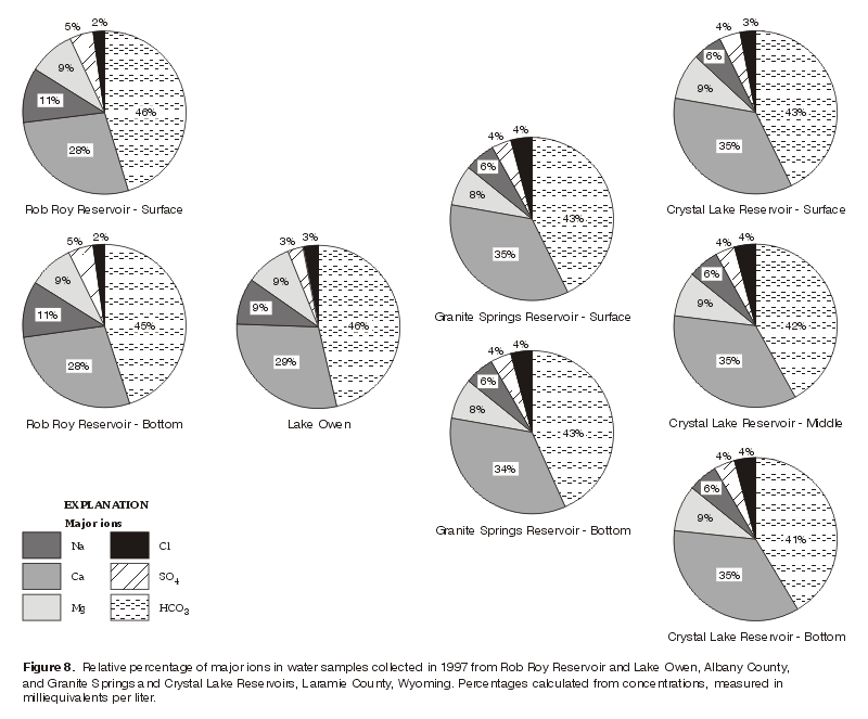
Relatively little difference in water chemistry existed between the top and bottom of Rob Roy Reservoir (table 2). The dissolved-solids concentration was 19 mg/L for the surface sample and 22 mg/L for the bottom sample (fig. 7). The water was a calcium bicarbonate type. The concentrations of selected major ions shown on the pie diagrams in figure 8 indicate no differences in the concentration of major ions between surface and bottom water samples. Dissolved fluoride concentrations were less than the detection level of 0.1 mg/L. Silica concentrations, as dissolved SiO2, increased slightly with depth (table 2; fig. 9). Nutrient concentrations generally were less than the detection level. An exception was dissolved nitrogen, as nitrite plus nitrate, in the bottom sample, which was 0.08 mg/L (table 2).
Some differences were detected in selected trace-element concentrations between the top and bottom samples collected at Rob Roy. Dissolved iron (fig. 10) and dissolved manganese concentrations (fig. 11) were higher in the bottom sample.
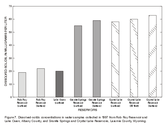
Figure 7. Dissolved-solids concentrations in water samples collected in 1997 from Rob Roy Reservoir and
Lake Owen, Albany County, and Granite Springs and Crystal Lake Reservoirs, Laramie County,
Wyoming. |
Figure 8. Relative percentage of major ions in water samples collected in 1997 from Rob Roy Reservoir and Lake Owen, Albany County,
and Granite Springs and Crystal Lake Reservoirs, Laramie County, Wyoming. Percentages calculated from concentrations, measured in
milliequivalents per liter. |
On July 23, 1998, bottom sediment samples were collected from five sites (fig. 2A) in Rob Roy and composited into a single sample. The composite sample was analyzed for selected constituents (table 3). The nitrogen concentration, reported as total nitrite plus nitrate, was 9 mg/kg, the highest concentration from all four reservoirs (table 3). Of the constituents analyzed, aluminum was present in the highest percentage (6.9 percent) and iron was next highest (3.1 percent). Most of the trace elements are present in concentrations in the microgram per gram range. Trace-element concentrations of arsenic, bismuth, cadmium, europium, gold, holmium, molybdenum, silver, tantalum, tin, and uranium were less than the detection limit. Cerium, chromium, thorium, and vanadium concentrations fit best with Group 1, the crustal average, rather than diabase or granitic rocks (fig. 12). The similarity is probably a reflection of the surrounding geology which is composed of sedimentary deposits (Tertiary age) and metasedimentary and metavolcanic rocks (Pre-Cambrian) (Love and Christiansen, 1985).
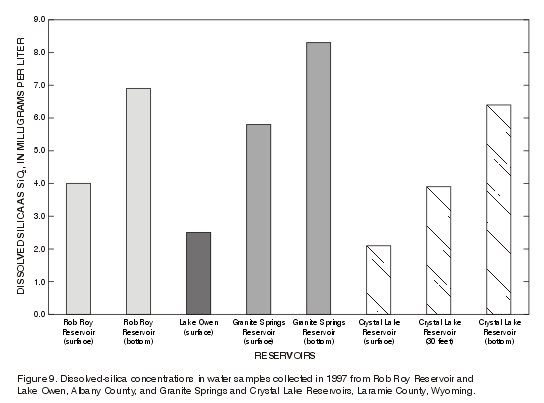
Figure 9. Dissolved-silica concentrations in water samples collected in 1997 from Rob Roy Reservoir and
Lake Owen, Albany County, and Granite Springs and Crystal Lake Reservoirs, Laramie County, Wyoming. |
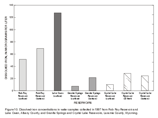
Figure 10. Dissolved-iron concentrations in water samples collected in 1997 from Rob Roy Reservoir and
Lake Owen, Albany County, and Granite Springs and Crystal Lake Reservoirs, Laramie County, Wyoming. |
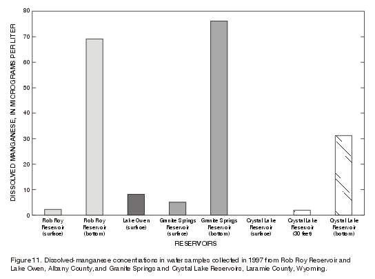
Figure 11. Dissolved-manganese concentrations in water samples collected in 1997 from Rob Roy Reservoir and
Lake Owen, Albany County, and Granite Springs and Crystal Lake Reservoirs, Laramie County, Wyoming. |
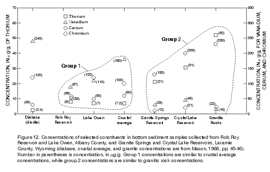
Figure 12. Concentrations of selected constituents in bottom sediment samples collected from Rob Roy Reservoir and Lake Owen, Albany County, and Granite Springs and Crystal Lake Reservoirs, Laramie County, Wyoming (diabase, crustal average, and granitic concentrations are from Mason, 1966, pp. 45-46). Number in parentheses is concentration, in mg/g. Group 1 concentrations are similar to crustal average concentrations, while group 2 concentrations are similar to granitic rock concentrations. |
[Table of Contents] [Abstract]
[Introduction]
[Rob Roy Reservoir]
[Lake Owen]
[Granite Springs
Reservoir] [Crystal Lake Reservoir]
[Summary]
[Appendix A]
[Appendix B]