Information: Information management is both a strategy, driven by customer needs, and an infrastructure, shaped by technology, for handling and distributing information. Information management crosses disciplinary and administrative boundaries. USGS information management activities organize, catalog, archive, maintain, and disseminate earth and biological science data and information so that all potential users are aware of and can acquire the information. The USGS distributes a variety of high quality earth and biological science information in the form of data bases, maps, and scientific and general interest publications. An increasing amount of this information is now available over the Internet and on CD-ROM. Properly managed information can be combined and interpreted for new understandings of earth and biological processes, and has multiple uses across disciplines in Government, the private sector, and the general public.
Geographic and Cartographic Information
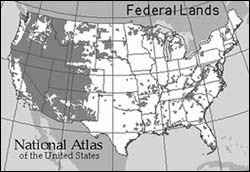
The National Atlas of the United States of America
The new National Atlas of the United States is an ambitious, Government-wide partnership led by the USGS that aims to make geographic information more readily accessible to individual Americans. The National Atlas is designed to
promote greater geographic awareness through the development and delivery of products that provide easy to use, map-like views of our natural and societal landscapes. It will include products designed to stimulate children and adults to visualize, comprehend, and even marvel at the
complex relationships between environments,
places, and people. The National Atlas is intended to serve the interests and needs of a diverse populace in many ways, such as:
- an essential reference,
- a framework for information discovery,
- an instrument of education,
- an aid in research, and
- an accurate and reliable source for scientific information.
The USGS and its partners delivered the first new National Atlas products in 30 years during FY 1998. These included:
- an online, interactive mapping system that allows citizens to make and explore their own maps within their favorite World Wide Web (WWW.) browser,
- information pages on the WWW that describe this project and its opportunities for business partnerships,
- an interactive mapping engine for the interagency http://www.recreation.gov/ web site,
- innovative and redesigned National Atlas paper maps, and
- complete, consistent, and authoritative digital map layers that can be downloaded and used to explore information gathered at a National level.
USGS and Microsoft Form Research Partnership
Now, with a few computer mouse clicks, scientists, planners, consumers, and school children can see U.S. Geological Survey aerial images with resolutions as close as 1.0 meters‹detailed enough to distinguish buildings and cars, but not people‹over the Internet using the new Micro-soft TerraServer. The website can be reached at http://www.terraserver.microsoft.com/. The U.S. Geological Survey and the Microsoft Corporation entered into a cooperative research and development agreement (CRADA) to make vast amounts of geospatial data available to the general public through the Internet. As part of a 36-month joint effort, Microsoft agreed to modify a massive volume of USGS geospatial data so the images can be quickly and easily displayed with unprecedented clarity over the Internet. The Microsoft TerraServer website opened to the public in June 1998 serving more than one terabyte (1 trillion bytes) of geospatial data from a user-friendly interface. The TerraServer enables users to view and download digital orthophoto quadrangle (DOQ) images‹digital images of aerial photography that combine the image characteristics of a photograph with the geometric qualities of a map.
The initial response to the TerraServer has been spectacular. Early statistics show the average number of hits at 12 million per day with a peak of almost 29 million hits on July 1. TerraServer is a mutually beneficial research effort where the Federal government and private industry have come together to provide general public access to USGS geospatial data while allowing Microsoft and other project partners to promote their technological contributions. The USGS looks forward to future opportunities in which to partner with private sector entities to expand access to valuable data and information resources.
USGS Digital Raster Graphics Now Available Nationwide
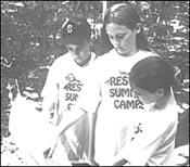
Summer campers learning to use a topographic map.
|
USGS Digital Raster Graphics (DRG's)that is, computer-readable images of topographic mapsare now available for all of the United States, Puerto Rico, the U.S. Virgin Islands, and the Pacific islands. DRG development began in early 1994; production began in October 1995. The DRG's of the Pacific islands, finished in March 1998, marked the completion of nationwide DRG coverage.
The program involved producing DRG's for approximately 59,000 topographic maps in 22 years, a massive undertaking conducted with project partners in the Federal and private sectors. DRG's have become an extremely valuable tool for use in emergency and hazards relief applications. Sales for FY1998 are projected to surpass 1 million dollars.
Digital Ortho-Imagery Grows
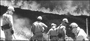
DOQ's support fire fighting efforts
|
National coverage of digital ortho-imagery quadrangles (DOQ's) grew to 48 percent in FY1998, up from 28 percent in FY1997. DOQ's are digital images that combine the image characteristics of an aerial photograph with the geometric qualities of a map. During the 1998 forest fire emergency in Florida, DOQ's provided up-to-date cartographic information for fire fighters. DOQ's are also used in Florida and elsewhere to update geospatial data relating to land use, hydrography, and transportation. Computer users around the world can now view and download the high resolution aerial images of USGS DOQ's at the Microsoft TerraServer website
(http://www.terraserver.microsoft.com/).
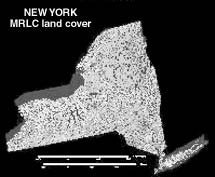
Regional Land Cover Mapping
Land cover mapping was completed for 23 of the conterminous States in FY 1998, bringing the total number of States completed to 30. The remaining 18 States will be completed in FY 1999, the final year of the project.
The Multi-Resolution Landscape Characteristics (MRLC) Consortium was formed in 1993 to consolidate Federal agency requirements for satellite data. Members include the U.S. Geological Survey, U.S. Environmental Protection Agency, National Oceanic and Atmospheric Administration, and U.S. Forest Service. This nationally consistent 30-meter land cover data set
is based on Landsat Thematic Mapper data and uses a consistent protocol and the hierarchical classification system adopted by the MRLC partners. The land cover data are used for land and water management, environmental monitoring, crop and vegetation studies, and climatic
investigations.
National Spatial Data Infrastructure
The USGS, as co-chair of the Federal Geographic Data Committee (FGDC), is supporting the development, implementation, and promotion of National Spatial Data Infrastructure (NSDI) data standards. In FY 1998 the USGS led four National standards development efforts: (1) the National Standard for Spatial Data Accuracy, (2) the Content Standard for Digital Orthoimagery, (3) the Content Standard for Digital Gridded Land Elevation Data, and (4) the Content Standard for Digital Geospatial Metadata. Additionally, the USGS is the maintenance authority for the Spatial Data Transfer Standard (SDTS) and supporting data profiles. The American National Standards Institute formally adopted SDTS as a national standard in July 1998.
Such data standards provide the geospatial data community with an improved and consistent approach for using and sharing geospatial data. They constitute a critical component to vigorous implementation of the National Spatial Data Infrastructure.
National Cooperative Geologic Mapping
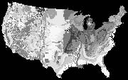
U.S. map depicts the distribution, character, and temporal and structural relations of bedrock units throughout the United States.
|
To reduce the loss of life and property from
debris flows and landslides, the USGS is cooperating with the State of California and counties and the National Weather Service to produce and distribute geologic maps which depict debris flow and deep-seated landslide hazard zones, as a component of landslide advisory notifications throughout the major urban areas of coastal California. This effort is being undertaken in anticipation of major winter storms that may result from the current El Niño phenomenon. USGS experience with catastrophic events associated with the previous El Niño of 1982-1983, combined with the availability of digital data (elevation, geologic materials, and locations of previous debris flows and landslides in the San Francisco Bay region), provide the basis for joint cooperation in targeting areas of particular vulnerability. The databases and resulting maps are generated from a geographic information system that includes cultural features such as roads, power grids, and population centers. Emergency response teams will use USGS database map information to evaluate the risk to society of this unusual weather phenomenon.
Ground Water Atlas of the United States
USGS has completed publication of an atlas of the Nation's major aquifers. The atlas comprises a series of print publications which describe the location, the extent, and the geologic and hydrologic characteristics of the important aquifers of the Nation. The series consists of 13 chapters, which describe the ground-water resources of regional areas that collectively cover the 50 States, Puerto Rico, and the U.S. Virgin Islands.
The Atlas also serves as a basic reference that describes the location, extent, and geologic and hydrologic characteristics of all the major aquifers. More information on the Ground Water Atlas can be found on the USGS Web site at http://wwwcapp.er.usgs.gov/publicdocs/gwa/.
Water Science for Schools
USGS's "Water Science For Schools" is a topic based Outreach World Wide Web site aimed at students, aged 9 to 90, who want to find out more about the many aspects of water. Topics include Water Basics, Earth's Water; and Special Topics such as Water Quality, Acid Rain, Water Use, and Water Data and Maps. The Web site also includes a Water Question-and-Answer section, a Picture Gallery; and an Interactive Activity Center where
students can answer Challenge Questions, Opinion Surveys, and Questionnaires. The site is available at http://ga.water.usgs.gov/edu/.
"WEBCAM" Installed at Verde River
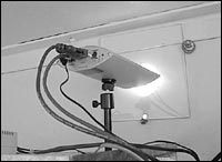
Webcam installed at streamgage shelter at Verde River near Scottsdale, Arizona.
|
The USGS Arizona District has taken a step forward to the very edge of World Wide Web technology with the installation of a "webcam" at a streamflow gage on the Verde River near Scottsdale, Arizona. This camera is installed in the gage house and transmits still pictures of the Verde River every hour. This is the first time USGS has used "live" images from a gage site to confirm hydrologic conditions at that site. These pictures are displayed on a web page at
http://az.water.usgs.gov/webcam/cam_09511300.html.
Decision Support for Restoration of Native Plants
The Beta Version 2.0 of a World Wide Web-based tool known as VegSpec was released to the public of wind breaks, or a host of other desires. In many of these cases, correct selection of plant species for a particular site relies on the best judgment of land managers based on regional soils and climate and on information contained in plant material handbooks. This information can be difficult for land managers to locate and incorporate in their decision-making. VegSpec is a decision-support tool that can help in this process. The USGS has been cooperatively developing this tool with the U.S. Department of Agriculture-Natural Resources Conservation Service and the U.S. Army Construction Engineering Research Laboratories. This software automates the selection of plants species based on site-specific conditions, and assists in the design and application of practices for establishment of wildland vegetation throughout the United States. Version 2.0 is a major refinement of a text-based version with a new graphical user interface. It also allows for efficient web-based access using current browser software.
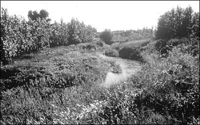
Riparian buffer strip
|
USGS Metadata Clearinghouse
In FY 1998, the USGS initiated operation of an online Metadata Clearinghouse as part of the National Biological Information Infrastructure (NBII) program. The NBII Metadata Clearinghouse (http://www.nbii.gov/clearinghouse.html) can be used to identify existing sources of biological information from government agencies, universities, and many other organizations. Internet users can search through an online catalog of standardized descriptions of biological data sets, technical reports, and other information products to locate sources that meet their particular requirements. Descriptions of additional data sets and information products are being added continually to the Clearinghouse. The USGS provides training and technical assistance to other Federal agencies, State governments, and individual scientists to help them to document their significant biological data sets and information products so that they can be included in the NBII Clearinghouse.
Access Expanded to Integrated Taxonomic Information System
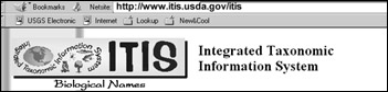
|
In FY 1998, the USGS collaborated with 5 other Federal agencies to expand public access to information on the names and classifications of North American plant and animal species through the Integrated Taxonomic Information System (ITIS) at . ITIS is the only comprehensive online source of scientific and common species names in the world today. In April 1998, USGS and its Federal partners received a Hammer award for Reinventing Government from the Vice President's National Performance Review. In FY 1998, the USGS also added to the ITIS system by providing access to an online directory of information on taxonomic scientists of North America and their respective areas of expertise (http://www.nbii.gov/tred/).
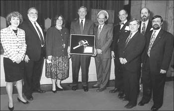
In April 1998, a scientific team from the U.S. Geological Survey received the Vice
presidentąs Hammer Award for the Integrated Taxonomic Information System (ITIS).
|
An Approach for Science-Based Decision-Making: Integration of Science, Monitoring, and Management
A prototype decision support system has been developed by USGS scientists and Upper Mississippi River National Wildlife and Fish Refuge (U.S. Fish and Wildlife Service) to provide a rapid-access, user-friendly, and scientifically-based tool to aid Mississippi River managers. Since most resource issues are evaluated in a partner-public framework, communicating often complex and voluminous scientific information rapidly and succinctly is central to successful science-based conflict resolution. This project built upon a joint effort "The Management Strategy for Migratory Birds on the Upper Mississippi River Corridor" to provide an integrated, ecological, and pro-active approach to management of migratory bird habitats in the context of other landscape, biological, and sociological components. Data from the Long-term Resource Monitoring Program, a cooperative State-DOI-Army Corps of Engineers effort authorized under the Water Resources Development Act of 1986, provide much of the underpinnings for the project. This is a digital decision support system that becomes an electronic ecosystem encyclopedia for planners. It integrates physical, land cover, biological, and social themes. Software provides for visual integration and cataloguing of most types of digital information including scalable GIS layers, text, and scanned images. The system is PC-based with available commercial software, making the manager's interface accessible and cost-effective. The prototype system is used daily by the La Crosse District of the Upper Mississippi River National Wildlife and Fish Refuge to make management decisions.
PREVIOUS || TABLE OF CONTENTS || NEXT
This page is https://pubs.usgs.gov/98financial/info.html
Maintained by Eastern Publications Group Web Team
Last updated July 6, 1999