INTRODUCTION
By Dennis P. Cox, Paul B. Barton, and Donald A. Singer
The U.S. Geological Survey has a long and distinguished history in assessing the mineral resources of the public domain, and that role remains active today in programs designed to assess the mineral resources of the lands administered by the U.S. Bureau of Land Management and Forest Service, the Alaska Mineral Resource Assessment Program, and the Conterminous United States Mineral Assessment Program. The Survey has thus an immediate and constantly recurring need to upgrade and maintain the capability of its staff to identify and assess areas favorable for mineral deposits. One major step toward fulfilling this need is the assembly of a comprehensive group of mineral deposit models that enable any geologist to compare his or her observations with the collective knowledge and experience of a much wider group of geoscientists.
This report deals exclusively with non-fuel minerals (including uranium), for these show a commonality of geologic expressions that differ markedly from those of the areally much larger (and economically even more important) coal, oil, and gas deposits.
This report has been assembled through the generous efforts of many persons. The authors of the individual models and many of the other sections are indicated. We all would appreciate it if the individual authors could be cited whenever practical rather than simply referring to the whole compilation.
Among the editors, Dennis Cox had the lead in soliciting the model authors and in assembling the brief models; Donald Singer played a similar role for all of the grade and tonnage models; and Paul Barton provided the attribute cross-indexes and carefully reviewed the overall package. The editors greatly appreciate the encouragement and suggestions from (in alphabetical order) Larry Bernstein, John H. DeYoung, Jr., Bob Earhart, Ralph Erickson, Fred Fisher, Bill Greenwood, Carroll Ann Hodges, Kate Johnson, Steve Ludington, Dick McCammon, Hal Morris, Rob Robinson, Don White, and many others. The editors were greatly helped by suggestions from geologists outside the USGS, particularly D. F. Sangster, R. V. Kirkham, and J. M. Franklin of the Geological Survey of Canada, and by Ryoichi Kouda, Takeo Sato, and Yukio Togashi of the Geological Survey of Japan. Among the many geologists from private industry who provided helpful information and suggestions were R. G. Blair, A. E. Soregaroli, E. I. Bloomstein, and G. E. McKelvey.
A "mineral occurrence" is a concentration of a mineral (usually, but not necessarily, considered in terms of some commodity, such as copper, barite or gold) that is considered valuable by someone somewhere, or that is of scientific or technical interest. In rare instances (such as titanium in a rutile-bearing black sand), the commodity might not even be concentrated above its average crustal abundance.
A "mineral deposit" is a mineral occurrence of sufficient size and grade that it might, under the most favorable of circumstances, be considered to have economic potential.
An "ore deposit" is a mineral deposit that has been tested and is known to be of sufficient size, grade, and accessibility to be producible to yield a profit. (In these days of controlled economies and integrated industries, the "profit" decision may be based on considerations that extend far beyond the mine itself, in some instances relating to the overall health of a national economy.)
On one hand, the field observations usually begin with "mineral occurrences" (or with clues to their existence) and progress with further study to "mineral deposits" and only rarely to "ore deposits," but we must present information that helps us deal with all classes of "mineral occurrences," not just "ore deposits." On the other hand, in terms of accessible information our sample is strongly biased toward "ore deposits," for it is only in them that sufficient exposure is available to develop a real knowledge of the overall character of the mineralization process. Some mineral occurrences are, therefore, unrecognized mineral deposits, while others are simply mineralized localities where ore-forming processes were so weak or incomplete that a deposit was not formed. Thus we summarize the state of knowledge regarding ore deposit models, and we call them "mineral deposit models" with the hope that what we have learned about large and high-grade metal concentrations will help us sort out all mineral occurrences to identify their true character and, we hope, to recognize which have potential to constitute ore deposits.
The attributes or properties of a mineral occurrence are, of course, those features exhibited by the occurrence. When applied to a model, these terms refer to those features possessed by the class of deposits represented by the model. It is useful to consider attributes on at least two scales: the first deals with local features that may be observed directly in the field (mineralogy, zonal patterns, local chemical haloes, and so on); the second is those features concerning the regional geologic setting and which must be interpreted from the local studies or may be inferred from global tectonic considerations (for instance, that the rock sequence under study represents a deep-water, back-arc rift environment, or that the area is underlain by anomalously radioactive high-silica rhyolite and granite). Two of the most prominent attributes, the commodities/geochemical patterns and the mineralogy, are cross-indexed to model types in Appendixes C and D, respectively.
To the greatest extent possible, models were constructed so as to be independent of site-specific attributes and therefore contain only those features which are transferable from one deposit to another. This goal is difficult to attain, because we do not always know which features are site specific.
The term "model" in an earth-science context elicits a wide variety of mental images, ranging from the physical duplication of the form of a subject, as in a scale model of the workings of a mine, to a unifying concept that explains or describes a complex phenomenon. In this context we shall apply only the latter usage. Therefore, let us propose a working definition of "model" in the context of mineral deposits, the overriding purpose being to communicate information that helps mankind find and evaluate mineral deposits. A mineral deposit model is the systematically arranged information describing the essential attributes (properties) of a class of mineral deposits. The model may be empirical (descriptive), in which instance the various attributes are recognized as essential even though their relationships are unknown; or it may be theoretical (genetic), in which instance the attributes are interrelated through some fundamental concept.
One factor favoring the genetic model over the simply descriptive is the sheer volume of descriptive information needed to represent the many features of complex deposits. If all such information were to be included, the number of models would escalate until it approached the total number of individual deposits considered. Thus we should no longer have models, but simply descriptions of individual deposits. Therefore, the compilers must use whatever sophisticated or rudimentary genetic concepts are at their disposal to distinguish the critical from the incidental attributes. It is commonly necessary to carry some possibly superficial attributes in order not to preclude some permissible but not necessarily favored, multiple working concepts.
The following example illustrates the problem. One of the commonly accepted attributes of the model for the carbonate-hosted lead-zinc deposits of the Mississippi Valley type is the presence of secondary dolomite. But do we know that this is essential? Suppose a deposit were found in limestone; would we reject its assignment to the Mississippi Valley class?
Or could it be correct that the critical property is permeability and that the formation of dolomite either (1) enhances permeability (and thereby makes the ground more favorable), or (2) reflects pre-existing permeability that is exploited by both the dolomite and the ore? Perhaps the dolomite merely records a particular range of Ca/Mg ratio in the fluid which in turn is characteristic of the basinal brines that constitute the ore fluid. In any event, the dolomite is a powerful ore guide and belongs somewhere in the "final model."
CLASSIFICATION OF MODELS USED IN THIS COMPILATION
For the purpose at hand the classification scheme has two requirements: (1) it must be open so that new types of deposits can be added in the future, and (2) the user must be able to find easily the appropriate models to apply to the rock and tectonic environments being investigated.
Figure 1 maps out the four logic trees that constitute a broad lithotectonic classification; this system is similar to one developed by Page and others (1982c). The classification of deposits by the environment of formation of their host rocks is continued on a finer scale in table 1. This classification scheme is relatively straightforward for deposits formed essentially contemporaneously with their host rock. However, for epigenetic deposits a conflict arises between the lithotectonic environment of the formation of the host and the lithotectonic environment of the mineralization process. Therefore, for epigenetic deposits we have selected the most important aspect of the lithotectonic alternatives and classified the deposit accordingly. This procedure inevitably introduces a substantial bias on the part of the classifier, thus we have followed a system of including, parenthetically, alternative classifications less favored by the compiler at the appropriate alternative points in the classification scheme.
Figure 1. Tree diagram showing relationship of broad geologic-tectonic environments to models. These deposit models are classified on a finer scale in table 1.
Table 1. Classification of deposit models by lithologic-tectonic environment ['indicates that model is not included in this bulletin]
Deposit environment Model No.
Mafic and ultramafic intrusions
Basal zone
Stillwater Ni-Cu -------------------------------------- 1
Intermediate zone
Bushveld chromitite ------------------------------------ 2a
Merensky Reef PGE Upper zone -------------------------- 2b
Upper zone
Bushveld Fe-Ti-V ------------------------------------ 3
Pipe-like deposits
Cu-Ni pipes -------------------------------------------- 4a
PGE pipes --------------------------------------------- 4b
Rift environment
Duluth Cu-Ni -PGE ----------------------------------- 5a
Noril'sk Cu-Ni-PGE ----------------------------------- 5b
Greenstone belt in which lowermost rocks of
sequence contain ultramafic rocks
Komatiitic Ni-Cu -------------------------------------- 6a
Synorogenic in volcanic terrace
Synorogenic-synvolcanic Ni-Cu -------------------------- 7a
Ophiolites
Podiform chromite ------------------------------------- 8a
(Placer Au-PGE) ------------------------------------- (39a)
Serpentine
Limassol Forest Co-Ni ------------------------------ 8c
Serpentine-hosted asbestos -------------------------- 8d
(Silica-carbonate Hg) ------------------------------- (27c)
(Low-sulfide Au-quartz vein) ------------------------- (36a)
Cross-cutting intrusions (concentrically zoned)
Alaskan PGE ---------------------------------------- 9
(Placer PGE-Au) ------------------------------------- (39b)
Alkaline complexes -------------------------------------- 11*
Diamond pipes ----------------------------------------- 12
Felsic intrusions
Be-Li pegmatites ------------------------------------ 13a
Sn-Nb-Ta pegmatites -------------------------------- 13b
Granitic intrusions
Wallrocks are calcareous
W skarn ---------------------------------------- 14a
Sn skarn ---------------------------------------- 14b
Replacement Sn ---------------------------------- 14c
Sn veins ---------------------------------------- 15b
Sn greisen --------------------------------------- 15c
(Low-sulfide Au-quartz vein) ------------------------- (36a)
(Homestake Au) ----------------------------------- (36b)
Anorthosite intrusions
(Anorthosite Ti) -------------------------------------- (7b)
Climax Mo ------------------------------------------ 16
(Fluorspar deposits) ----------------------------------- (26b*)
Wallrocks are calcareous
Deposits near contact
Porphyry Cu. skarn-related --------------------------- 18a
Cu skarn ----------------------------------------- 18b
Zn-Pb skarn -------------------------------------- 18c
Fe skarn ----------------------------------------- 18d
Carbonate-hosted asbestos --------------------------- 18e
Deposits far from contact
Polymetallic replacement ----------------------------- 19a
Replacement Mn ----------------------------------- 19b
(Carbonate-hosted Au) ------------------------------ (26a)
Wallrocks are coeval volcanic rocks
In granitic rocks in felsic volcanics
Porphyry Sn --------------------------------------- 20a
Sn-polymetallic veins -------------------------------- 20b
In calcalkalic or alkalic rocks
Porphyry Cu-Au ------------------------------------ 20c
(epithermal Mn) ------------------------------------ (25g)
Porphyry Cu-Mo ----------------------------------- 21a
Porphyry Mo, low-F --------------------------------- 21b
Porphyry W --------------------------------------- 21c*
Deposits within wallrocks
Volcanic hosted Cu-As-Sb --------------------------- 22a
Au-Ag-Te veins ----------------------------------- 22b
Polymetallic veins ---------------------------------- 22c
(Epithermal quartz-alunite Au) ----------------------- (25e)
(Low-sulfide Au-quartz vein) ------------------------- (36a)
Extrusive rocks
Basaltic Cu ------------------------------------------ 23
(Sediment-hosted Cu) ---------------------------------- (30b)
Marine, including ophiolite-related
Cyprus massive sulfide ---------------------------------- 24a
Besshi massive sulfide ---------------------------------- 24b
Volcanogenic Mn -------------------------------------- 24c
Blackbird Co-Cu -------------------------------------- 24d
(Komatiitic Ni-Cu) ------------------------------------- (6a)
Deposits mainly within volcanic rocks
Hot-spring Au-Ag ----------------------------------- 25a
Creede epithermal vein ------------------------------- 25b
Comstock epithermal vein ----------------------------- 25c
Sado epithermal vein -------------------------------- 25d
Epithermal quartz-alunite Au -------------------------- 25e
Volcanogenic U ------------------------------------ 25f
Epithermal Mn ------------------------------------- 25g
Rhyolite-hosted Sn --------------------------------- 25h
Volcanic-hosted magnetite ---------------------------- 25i
(Sn polymetallic veins) ------------------------------- (20b)
Deposits in older calcareous rocks
Carbonate-hosted Au-Ag ---------------------------- 26a
Fluorspar deposits ---------------------------------- 26b*
Deposits in older elastic sedimentary rocks
Hot-spring Hg ------------------------------------- 27a
Almaden Hg --------------------------------------- 27b
Silica-carbonate Hg --------------------------------- 27c
Simple Sb ---------------------------------------- 27d
Algoma --------------------------------------------- 28b
(Volcanogenic Mn) ------------------------------------- (24c)
(Volcanogenic U) ------------------------------------- (25f)
(Low-sulfide Au-quartz vein) ----------------------------- (36a)
(Homestake Au) -------------------------------------- (36b)
(Volcanogenic U.) ------------------------------------- (25f)
Sedimentary rocks
H. Clastic sedimentary rocks
Olympic Dam Cu-U-Au --------------------------------- 29b
(Sandstone U) ---------------------------------------- (30c)
(Basaltic Cu) ----------------------------------------- (23)
Sandstone
Sandstone-hosted Pb-Zn ------------------------------- 30a
Sediment-hosted Cu ----------------------------------- 30b
Sandstone U ----------------------------------------- 30c
(Basaltic Cu.) ----------------------------------------- (23)
(Kipushi Cu-Pb-Zn) ------------------------------------ (32c)
(Unconformity U-Au) ----------------------------------- (37a)
Shale-siltstone
Sedimentary exhalative Zn-Pb ---------------------------- 31a
Bedded barite ----------------------------------------- 31b
Emerald veins ----------------------------------------- 31c
(Basaltic Cu.) ----------------------------------------- (23)
(Carbonate-hosted Au-Ag) ------------------------------- (26a)
(Sediment-hosted Cu.) ---------------------------------- (30b)
Southeast Missouri Pb-Zn ------------------------------- 32a
Appalachian Zn --------------------------------------- 32b
Kipushi Cu-Pb-Zn ------------------------------------- 32c
(Karst bauxite) ---------------------------------------- (38c)
Igneous heat sources present
(Polymetallic replacement) ------------------------------- (19a)
(Replacement Mn) ------------------------------------- (19b)
(Carbonate-hosted Au-Ag) ------------------------------ (26a)
(Fluorspar deposits) ------------------------------------ (26b)
Mn nodules ------------------------------------------ 33a*
Mn crusts ------------------------------------------- 33b
Shelf
Superior Fe ------------------------------------------ 34a
Sedimentary ----------------------------------------- 34b
Phosphate, upwelling type ------------------------------- 34c
Phosphate, warm-current type ---------------------------- 34d
Restricted basin
Marine evaporite -------------------------------------- 35a*
Playa evaporite --------------------------------------- 35b*
(Sedimentary exhalative Zn-Pb) -------------------------- (31a)
(Sedimentary Mn) ------------------------------------- (34b)
Regionally metamorphosed rocks
Homestake Au ------------------------------------------- 36b
(Serpentine-hosted asbestos) ------------------------------- (8d)
(Gold on flat faults) -------------------------------------- (37b)
Gold on flat faults ----------------------------------------- 37b
Surficial and unconformity-related
M. Residual
Lateritic Ni --------------------------------------------- 38a
Bauxite, laterite type ------------------------------------- 38b
Bauxite, karst type --------------------------------------- 38c
(Unconformity U-Au) ------------------------------------- (37a)
Placer PGE-Au ----------------------------------------- 39b
Shoreline placer Ti --------------------------------------- 39c
Diamond placers ---------------------------------------- 39d
Stream placer Sn ---------------------------------------- 39e
(Quartz pebble conglomerate Au-U) --------------------------- (29a)
MODEL NAMES
Each model has been assigned a name that is derived either from the special characteristics of the classes or from a type locality. The latter strategy was employed to avoid excessively long descriptive names. The use of type names derived from specific deposits does produce confusion in some readers, however, who may feel, for example, that a deposit that does not look "exactly" like Comstock cannot be represented by a "Comstock epithermal vein" model. This confusion may be minimized by realizing that most models are blends of attributes from a large number of deposits and that the names are only conveniences, not constrictions. The contributors to this report and the literature in general are not without disagreements regarding nomenclature (as well as genetic aspects and some facets of the groupings made here), but provision for alternative names is made in the model format under the heading of approximate synonyms.
DESCRIPTIVE MODELS
Because every mineral deposit, like every fingerprint, is different from every other in some finite way, models have to progress beyond the purely descriptive in order to represent more than single deposits. Deposits sharing a relatively wide variety and large number of attributes come to be characterized as a "type," and a model representing that type can evolve. As noted above, generally accepted genetic interpretations play a significant role in establishing model classes. Here we shall emphasize the more descriptive aspects of the deposits because our goal is to provide a basis for interpreting geologic observations rather than to provide interpretations in search of examples. The attributes listed are intended to be guides for resource assessment and for exploration, both in the planning stage and in the interpretation of findings.
The descriptive models have two parts. The first, the "Geological Environment," describes the environments in which the deposits are found; the second gives the identifying characteristics of the deposits. The headings "Rock Types" and "Textures" cover the favorable host rocks of deposits as well as source rocks believed to be responsible for hydrothermal fluids which may have introduced epigenetic deposits. "Age" refers to the age of the event responsible for the formation of the deposit. "Tectonic Setting" is concerned with major features or provinces (perhaps those that might be portrayed only at 1:1,000,000 or smaller scale), not ore control by structures that are local and often site-specific. "Associated Deposits" are listed as deposits whose presence might indicate suitable conditions for additional deposits of the type portrayed by the model.
The second part of the model, the "Deposit Description," provides the identifying characteristics of the deposits themselves, particularly emphasizing aspects by which the deposits might be recognized through their geochemical and geophysical anomalies. In most cases the descriptions also contain data useful in project planning for mineral assessment or exploration; this aspect is especially important where limited financial and manpower resources must be allocated to the more significant tasks.
GRADE-TONNAGE MODELS
Estimated pre-mining tonnages and grades from over 3,900 well-explored, well-characterized deposits were used to construct 60 grade-tonnage models. Where several different estimates were available for a deposit, the estimated tonnages associated with the lowest cutoff grades were used. Grades not available (always for by-products) were treated as zero. Except for a few instances, the data base is so large as to preclude specific references. Several published compilations of data were particularly useful sources for multiple deposit types (Canada Department of Energy, Mines and Resources, 1980; DeYoung and others, 1984; Krauss and others, 1984; Laughlin, 1984; Menzie and Mosier, 1985; Mosier and others, 1983; Mosier and others, in press; Singer and others, 1980; Yamada and others, 1980). The U.S. Geological Survey has a great deal of data available in the Mineral Resources Data System.
The grade-tonnage models are presented in graphical format to make it easy to compare deposit types and to display the data. All plots show either grade or tonnage on the horizontal axis, while the vertical axis is always the cumulative proportion of deposits. Plots of the same commodity or tonnages are presented on the same scale; a logarithmic scale is used for tonnage and most grades. Each dot represents an individual deposit (or, rarely, a district), cumulated in ascending grade or tonnage. Where a large number of deposits is plotted, individual digits represent the number of deposits. Smoothed curves are plotted through arrays of points, and intercepts for the 90th, 50th, and 10th percentiles are constructed. For tonnages and most grades, the smoothed curves represent percentiles of a lognormal distribution that has the same mean and standard deviation as the observed data; exceptions are plots where only a small percentage of deposits had reported grades and grade plots that are presented on an arithmetic scale, such as iron or manganese, for which the smoothed curve was fit by eye. Summary statistics by deposit type are provided in Appendix B. The number of deposits in each type is indicated at the upper right of each diagram. The deposits used to construct each model are listed with the model and cross-indexed to model types in Appendix E. Correlations among grades and between tonnage and each grade are indicated only when significant at the 1 percent level.
There are important limitations inherent in the data base used for all grade-tonnage models. Estimates of cutoff grades within individual deposit types can vary because of regional, national, or operator differences. All too commonly there is no mention of the actual cutoff grades or mining widths that are incorporated into published reserve figures; nevertheless, the grade-tonnage figures given do represent material that the company or the government believed might someday be economic to mine. Stratiform deposits of large areal extent, such as phosphate or sedimentary manganese, are special problems because of differences in opinion and practice regarding how closely drilled they must be to "prove" ore tonnages and regarding the thicknesses and depths of what may be considered for eventual mining. Effects of another source of variation, mining methods, are recognized in some of the placer models; typically, however, mining methods are fairly consistent within a deposit type. In a few instances, irregular cumulative frequency plots reflect mixing of economic and scientific data sources, such as in the plot of gold in porphyry copper deposits. In spite of the current difficulty of quantifying variation of grades and tonnages with respect to changes in cutoff grades or mining methods, the models presented here are believed to account for the main source of variation in grades and tonnages of mineral deposits-variation due to differences among types of deposits.
The question of whether one counts deposits within a cluster of related deposits as individuals or as a total will probably never be resolved to everyone's satisfaction. Some geostatisticians would separate each ore body (and then argue about whether two operations on the same body should be counted separately), whereas some economic geologists would lump everything from a single district (and then argue about district boundaries). For the most part the entities summarized are individual deposits, but in some instances such data are mixed with data representing entire districts. Because of these inconsistencies, some care is necessary in comparing grade-tonnage models between deposit types or in comparing this summary with those prepared using alternative methods.
Care is also warranted in interpreting the grade distributions for which data are missing; this concerns principally by-product grades. In some instances, such as the platinum-group element (PGE) contents in podiform chromite and the cobalt content of laterites, the fragmentary information given probably represents the entire class. In other instances, such as the lead content of Cyprus massive sulfide deposits, the missing grades probably represent values below the lowest reported grades. The grades derived from studies of trace elements in ores more probably represent the former situation rather than the latter.
Deposits strongly suspected to be small or very low grade are seldom sampled well enough to be characterized in terms of grade and tonnage, thus the sample of many deposit classes is truncated by economics. Nonetheless, probably 40 percent of the deposits used in these models are, in fact, non-economic today; and a perusal of the figures will discover examples of both small deposits and low-grade deposits.
Potential metal supply is dominated by the very few largest tonnage deposits, as shown by Singer and DeYoung (1980), who also pointed out that inverse correlations between grade and tonnage are surprisingly rare. Thus the fact that a deposit is large does not necessarily mean that it will prove to be of low grade. This means that most low-grade deposits are not likely to have huge resources and also that the omission of a few low-grade or small tonnage deposits will not seriously degrade the predictions of potential national supplies for most commodities. In contrast, the missing low-grade and small deposits suggest that the grade-tonnage models represent a biased sample of the large number of low-grade or small-tonnage occurrences and prospects found by exploration. This fact must be considered in cases where the number of undiscovered deposits is estimated. In order for the
estimated number of deposits to be consistent with a grade-tonnage model, approximately half of the deposits estimated should have greater than the model's median tonnage or grade. Thus the probability that an untested prospect represents a significant deposit can too easily be overestimated.
OTHER TYPES OF MODELS AND THEIR INTERRELATIONSHIPS
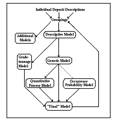
The bulk of this report deals with descriptive mineral deposit models and their grade-tonnage counterparts, but there are other useful aspects which we wish to discuss even though we have not yet had the opportunity to develop or exploit them. They are the genetic, occurrence probability, and quantitative process models.
Many authors prefer to keep a clear distinction between descriptive and genetic models, apparently feeling that the descriptive models somehow represent "pure truth" whereas the genetic constitute a less objective philosophical position (or at least make the investigator "skate on thin ice"). It is altogether desirable to avoid confusing interpretation with fact; but it is well to remember, for example, that each time a field geoscientist extrapolates geology across a covered area he or she adds an element of "interpretation" to a "factual" map, and that this interpretation is not necessarily any more "real" (or "unreal") than, for example, an isotope geologist's conclusion that a given oxygen and hydrogen isotopic signature extracted from fluid inclusions points to a meteoric origin for the fluid. The point is that the whole of our professional knowledge rests on a broad continuum of interpretations; many of them are so commonly accepted that they are no longer questioned, but many others still evoke challenges. Thus we suggest that a combination descriptive-genetic model is not inconsistent with professional practice. The model begins as a description, but various aspects of the model become genetic as they acquire satisfactory genetic explanations. Eventually much of the model becomes genetic, as has happened, for example, with the Cyprus-type massive sulfide deposits or the sandstone uranium deposits of the Colorado Plateau.
As the attributes of a model become understood in a genetic sense, the descriptive model evolves to a genetic model:
1. Genetic models are compilations of the properties of a group of related deposits in which the reasons for certain attributes being favorable are identified. Descriptive models evolve into genetic models, and as such they become far more flexible and powerful.
We have presented the three model subtypes above as if they constituted a linear logical sequence leading toward the "final" model, but in fact there must be an iterative relationship among descriptive, genetic, and grade/tonnage models. The consequence of examining any of these three may be a reassessment of the groupings of deposits chosen to be represented by a model type and the redesignation of the attributes diagnostic for that type.
With a dominantly genetic model in hand, two more model types can be generated:
2. Occurrence probability models are models that predict the probability of a deposit (of a size and grade indicated by the appropriate grade-tonnage models) occurring within a given area. As with the descriptive and genetic models, probability models that are tied to lithic or structural geologic entities (that is, they are genetic) are far more focused; in fact, it is probably impossible to generate a useful probability model before the establishment of a genetic model. Accurate probability models are very difficult to construct because although the technical community has very complete data on mineral producers (mines), the data on non-producing mineral deposits (prospects and mineral shows) are much less well documented, a point also covered in the discussion of grade-tonnage models. Even more importantly, data on barren areas are sparse. We must extrapolate from a very fragmentary base toward a completely unseen target.
There is much to learn before the probability model can be made a dependable tool; yet the successful targeting of exploration programs by industry demonstrates that, at least on a qualitative basis, areas with better-than-average probabilities can be identified. It is worth noting, also, that mineral fuels are much more predictable and now can have realistic probability-of-occurrence values attached to specific volumes of sediments provided that the initial character and post-depositional histories of the sediments are well known. It is a distant but not unreasonable dream to anticipate that some day we shall approach that level of certainty for some types of nonfuel mineral deposits.
3. Quantitative process models are models that describe quantitatively some process related to mineral deposit formation; they are offshoots of the genetic model. Examples would be models of heat or fluid flow around a cooling pluton; rates of crystal growth as functions of supersaturation, impurities, and temperature; or sequences and amounts of minerals deposited from evaporating seawater.
All five of these model subtypes can be parts of the "final" model, and recycling of the model back to the original groupings stage helps refine the selection process. Figure 2 shows the flow of information that results in the generation of the models we have discussed.
Table 2 compares the five model subtypes with five distinct types of uses for the information. Note that persons engaged in research guidance and especially exploration and development have broad-ranging needs, whereas those dealing with the availability of minerals or of land-use allocation have less use for genetic or quantitative process models. Overall there is a need for a comprehensive array of mineral deposit models to meet these individual
Figure 2. Flow sheet showing evolution of model types. Individual model subtypes are discussed in text. It is essential that such a structure represents the repetitive cycling of information leading to continual refinement of groupings of deposits that represent each model type.
MATURITY OF DESCRIPTIVE-GENETIC MODELS
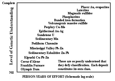
The rate at which we gain understanding and the current levels of genetic knowledge vary considerably from one deposit type to another, as figures 3 and 4 show. Such types as placers and evaporites are well known genetically and the problems in their exploration and utilization concern local site-specific geologic issues rather than mineral genesis or the degree of maturation of the model. In contrast, others such as the Coeur d'Alene Ag-Pb-Zn veins, or the massive Zn-Mn-Fe oxide/silicate bodies at Franklin and Sterling Hill, or the Cu-U-Au at Olympic Dam, or the Cu-Zn-Pb-Ge ores of Kipushi and the Tsumeb pipe remain genetic enigmas despite, in the instances of the first two, extensive research spanning many years. Still others, such as the diamond-bearing kimberlite pipes, are geologically well understood regarding their origin yet very poorly understood in terms of the reasons for their existing at any particular site. Our rate of acquisition of information is very irregular, as the schematic diagram in figure 3 shows. The several scarps between plateaus in the knowledge curve for the marine phosphate model might mark, successively, the recognition that the phosphate was a chemical precipitate, that it occurred on continental shelves where upwelling of deep marine waters occurred, and that the upwelling regions were related to wind and current patterns that were tied to the global configuration of the continents and ocean basins. A second example from the Mississippi Valley-type ores might involve scarps marking the recognition (from fluid-inclusion evidence) that the ores were deposited from warm (about 100 °C) highly saline solutions that could represent neither simple surface nor marine waters. A second scarp might be associated with the recognition that the deposits were integral parts of a regional hydrologic regime whose distribution and character was susceptible to interpretation.
Table 2. Comparison of application of the five model subtypes by various users
[Level of use: Major, X; minor, X; minimal, x]
| Grade/tonnage | Descriptive | Genetic |
Probability of
occurrence |
Quantitative process |
|
| Exploration/development | X | X | X | X | X |
| Supply potential | X | x | x | X | x |
| Land use | X | X | x | X | x |
| Education | x | X | X | X | X |
| Research guidance | X | X | X | X | X |
Figures 3 and 4 bring out another point: some aspects of any model always remain to be determined, thus we never acquire a "complete" model. Indeed, the approach to "complete" understanding is asymptotic, and a lot of additional effort to clear up the "last" uncertainty in a nearly perfect model is probably unwarranted. But, as the examples in figure 3 show, new ideas and new technologies can provide the impetus for new spurts in knowledge for heretofore incomplete models.
Note that the horizontal axis in figure 3 is simply "years of effort" devoted to fundamental geologic investigation. The scale certainly needs to be exponential in order to fit the intensively studied and sparsely studied deposit types, but this figure is strictly schematic, there being no source of documentation for either coordinate. The figure also indicates that different deposit types may require different amounts of effort to achieve a similar level of genetic understanding.
Figure 4 shows a hypothetical growth curve along which different types of deposits have been schematically arrayed. Because some deposits (such as volcanogenic massive sulfides) are so much more difficult to understand than others (gold placers), the horizontal axis has been "normalized" by plotting a ratio of effort done to effort needed thereby permitting a smooth, although admittedly subjective and schematic, curve to be illustrated. As with figure 3, there is no documentation to support this diagram, although the general concept meets with agreement among most contributors to this volume.
Figure 3. Schematic growth patterns for understanding of some typical genetic models. Individual curves discussed in text.
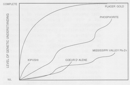
Figure 4. Comparison of relative levels of understanding of some important model types. Vertical coordinate same as for figure 3; but because difficulty of acquiring the genetic information differs so widely among model types, the horizontal coordinate is "normalized" as noted in text.