Introduction
by D.J. Varnes and W.Z. Savage
In 1990, the U.S. Geological Survey (USGS), with the assistance of scientists provided by a cooperative agreement between the USGS and the Istituto di Ricerca per la Protezione Idrogeologica (IRPI) of the Italian National Research Council, began a new study of the Slumgullion earth flow in the San Juan Mountains near Lake City, Colo. This famous landslide (figs. 1 and 2) has been described by numerous investigators (Endlich, 1876; Howe, 1909; Atwood and Mather, 1932; Burbank, 1947; Crandell and Varnes, 1960, 1961; Keefer and Johnson, 1983). It was chosen for a comprehensive study of landslide processes because part of it apparently has been moving continuously for the past 300 years, transporting material hundreds of meters and repeatedly creating and destroying surface features such as folds and faults. Also, movement data have been collected periodically on the flow for more than 30 years.
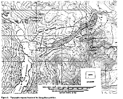
Figure 1.-- Topographic map and location of the Slumgullion earth flow.

Figure 2.-- Slumgullion earth flow. Lake San Cristobal is at lower right. The inactive landslide extends from the lake uphill to the active toe. Active toe is prominent light-colored bulge uphill from where Colorado State Highway 149 crosses the earth flow. Active flow extends from active toe to prominent main scarp at top of photograph.
The Slumgullion earth flow occurs in altered Tertiary volcanic rocks and consists of a younger, active, upper part that moves on and over an older, much larger, inactive part. Based on radiocarbon and tree-ring dating, the younger, active part is about 300 years old. The older, inactive part, which dammed the Lake Fork of the Gunnison River creating Lake San Cristobal, is about 700 years old (Crandell and Varnes, 1960, 1961). The entire landslide is 6.8 km long and has an estimated volume of 170x106 m3. The active part of the landslide is 3.9 km long and has an estimated volume of 20x106 m3 (Parise and Guzzi, 1992).
On January 26-27, 1994, a meeting of many of the study participants was held in Golden, Colo., to review the progress of ongoing investigations. This Bulletin summarizes the presentations given at this meeting.
The first six chapters are concerned with the geological aspects of our investigations. Chapter 1 summarizes the chronology of the Slumgullion slide and presents some additional background on local surficial geology. This chapter is part of a larger study aimed at understanding geologic and climatic controls on landsliding and evaluating the interrelations between earth-flow movement and late Holocene climatic change. Chapter 2 presents the results of detailed field studies on the kinematics of the active part of the earth flow. The kinematic investigations are fundamental to understanding slide movement and determining what information about flow processes within the slide can be obtained from the study of features at the ground surface. Chapters 3 and 4 contain the results of field studies on the geology of the main scarp of the Slumgullion landslide and its retreat. As part of these studies, photogrammetric measurements are being made to establish the rate of retreat of the main scarp of the slide. These studies are of interest, because the main scarp provided material for the older, inactive slide and still provides material for the newer, active slide. Chapter 5 presents the results of recent field investigations of a newly identified Slumgullion landslide deposit. This deposit, which may be the result of a "spill-over" of Slumgullion landslide material, may be critical to understanding the slide's early history. Chapter 6 pertains to the 700-hundred-year-old natural dam formed by the toe of the inactive slide. The continued stability of this dam, which created Lake San Cristobal, is of great importance to Lake City and the surrounding area.
Chapters 7 through 10 describe surveying, photogrammetric, and modeling efforts to understand movements in the newer and older parts of the Slumgullion earth flow. Chapter 7 discusses control and deformation surveys carried out on the landslide. The control surveys have established a coordinate system for all Slumgulllion studies, particularly the photogrammetric measurement of surface movement discussed in chapters 8 and 9. These measurements are the first to be done here, not only by standard analog and analytical photogrammetric methods, but also by a newly developed digital method. Aerial photographs were obtained in 1985 and 1990, precise survey control was established for the 1990 photography, and the same ground control was applied to the 1985 photography. As part of the deformation surveys discussed in chapter 7, leveling is being done to detect vertical movements in the inactive part of the earth flow in front of the advancing active toe.
The levelling work is of importance because, as mentioned previously, the Slumgullion earth flow consists of two parts, a lower, older inactive part and an upper, younger active part. The upper part is overriding the older part along a 40-m-high bulging and raveling front. The lower, older part is crossed by State Highway 149 connecting Lake City and Creede, Colo., and is increasingly occupied by condominiums and other structures near Lake San Cristobal. We have assumed that the older slide mass is stable, but there is no direct evidence for stability other than verticality of trees on the older slide mass and absence of major distress on the highway. However, as will be described in chapter 7, the surcharge of the active part is causing minor deformation in older material at and near the base of the active front. The most general deformation is depression, which seems to decrease away from the active front. Because we do not know how far ahead of the advancing active front the effects of the surcharge may eventually be felt, or at what rate deformation over large areas, if any, is occurring, a theoretical model to supplement intermittent field measurements and to predict this deformation was developed. This model is described in chapter 10.
The remaining five chapters discuss the geophysical and geotechnical aspects of the Slumgullion research effort. Chapter 11 reports the geotechnical properties of materials collected from the surface of the landslide, and chapter 12 describes studies of fault creep at various locations on the slide using modified tide-gage wire extensometers. Chapter 13 records the seismic reflection and refraction survey that established the position of the base of the inactive slide in the area below the active toe. Chapter 14 describes measurements of fault creep and slidequakes along a major strike-slip fault bounding the active slide. This work supports the hypothesis that processes involved in landslide faulting are in many ways analogous to those that operate in crustal-scale faulting. Chapter 15 concerns an experiment conducted to measure horizontal velocities at a number of points on and off the slide using the Global Positioning System (GPS). This work confirms that modern GPS technology may permit the rapid assessment of velocity fields at the landslide surface.
Upon the completion of the studies reviewed here, further geotechnical, geophysical, and hydrologic studies will be made at selected sites on the earth flow to collect material-property data and ground-water flow data needed for quantitative models of earth-flow movement. The material-property data will include drained and undrained strengths and rheological parameters of the soils in the earth flow. Ground-water flow data will initially be collected from observation of stream levels, ponds, and seeps, and later from observation wells and piezometers.
Finally, the kinematic, geophysical, geotechnical, and hydrological data collected at the Slumgullion earth flow will be combined into quantitative models for hillslope stability. The objective of these studies is to develop better models for evaluation of slope stability, which then can be tested directly at the Slumgullion earth flow, a large-scale natural laboratory.
References Cited
Atwood, W.W., and Mather, K.F., 1932, Physiography and Quaternary geology of the San Juan Mountains, Colorado: U.S. Geological Survey Professional Paper 166, 176 p.
Burbank, W.S., 1947, Lake City area, Hinsdale County, in Mineral Resources of Colorado: Colorado Mineral Resources Board, p. 439-443.
Crandell, D.R., and Varnes, D.J., 1960, Slumgullion earthflow and earthslide near Lake City, Colorado [abs.]: Geological Society of America Bulletin, v. 71, no. 12 pt. 2, p. 1846.
______1961, Movement of the Slumgullion earthflow near Lake City, Colorado, in Short Papers in the Geologic and Hydrologic Sciences: U.S. Geological Survey Professional Paper 424-B, p. B136-B139.
Endlich, F.M., 1876, Report of F.M. Endlich, in U.S. Geological and Geographical Survey (Hayden) of the Territories Annual Report 1874, 203 p.
Howe, E., 1909, Landslides in the San Juan Mountains, Colorado: U.S. Geological Survey Professional Paper 67, 58 p.
Keefer, D.K., and Johnson, A.M., 1983, Earth flows: morphology, mobilization, and movement: U.S. Geological Survey Professional Paper 1264, 56 p.
Parise, M., and Guzzi, R., 1992, Volume and shape of the active and inactive parts of the Slumgullion landslide, Hinsdale County, Colorado: U.S. Geological Survey Open-File Report 92-216, 29 p.

![]() U.S. Department of the Interior |
U.S. Geological Survey
U.S. Department of the Interior |
U.S. Geological Survey
URL: http://pubsdata.usgs.gov/pubs/bul/b2130/Introduction.html
Page Contact Information: GS Pubs Web Contact
Page Last Modified: Friday, 23-Mar-2012 14:31:51 EDT