ABSTRACT Historical and geological data indicate that significant changes can occur in the Earth's climate on time scales ranging from years to millennia. In addition to natural climatic change, climatic changes may occur in the near future due to increased concentrations of carbon dioxide and other trace gases in the atmosphere that are the result of human activities. International research efforts using atmospheric general circulation models (AGCM's) to assess potential climatic conditions under atmospheric carbon dioxide concentrations of twice the pre-industrial level (a "2 X CO2" atmosphere) conclude that climate would warm on a global basis. However, it is difficult to assess how the projected warmer climatic conditions would be distributed on a regional scale and what the effects of such warming would be on the landscape, especially for temperate mountainous regions such as the Western United States. In this report, we present a strategy to assess the regional sensitivity to global climatic change. The strategy makes use of a hierarchy of models ranging from an AGCM, to a regional climate model, to landscape-scale process models of hydrology and vegetation. A 2 X CO2 global climate simulation conducted with the National Center for Atmospheric Research (NCAR) GENESIS AGCM on a grid of approximately 4.5o of latitude by 7.5o of longitude was used to drive the NCAR regional climate model (RegCM) over the Western United States on a grid of 60 km by 60 km. The output from the RegCM is used directly (for hydrologic models) or interpolated onto a 15-km grid (for vegetation models) to quantify possible future environmental conditions on a spatial scale relevant to policy makers and land managers. INTRODUCTION Although there remains considerable debate on the issue of global warming, computer models suggest that the increasing atmospheric concentrations of carbon dioxide and other "greenhouse" gases (GHG) released by human activities will cause global warming during the next century. In addition, instrumental measurements suggest that the Earth's climate has warmed during the past few decades, perhaps reflecting the initial phase of "greenhouse" warming (Houghton and others, 1996). Geologic studies of past periods of global warmth and simulations of these past climates by numerical models suggest that the degree of warming can vary greatly across the globe and that precipitation regimes are affected differently in different regions (Lauritzen and Anderson, 1995; Dowsett and others, 1994; Thompson and Fleming, 1996; Poore and Sloan, 1996). Given the complex nature of regional responses to global warming and the fact that natural climate variability is a complicating factor, better tools are needed to assess the impacts of a range of likely future climate variations on the Western United States and elsewhere. Climate change will directly affect water availability and quality, agriculture, forestry, power production from dammed rivers, and the storage of toxic materials. Entire ecosystems will be affected, as will a wide variety of public lands, including Native Lands, National Parks, National Forests, and range lands managed by the Bureau of Land Management. Thus, it is important that policy makers, land managers, and other interested parties understand the sensitivity of these ecosystems to potential climate change. In this report, we present examples of the sensitivity of water and vegetation resources to a possible scenario of future climate in the Western United States. STRATEGY The Western United States has a diverse array of regional
climates due to physiography and the interplay of air masses
originating from different source areas (Mock, 1996; Thompson
and others, 1993). To deal with this complex situation, we used
the sequential application of a hierarchy of climate and landscape
models to simulate the regional-scale responses to climate change
of streams, lakes, and natural vegetation (table 1). At the top
of the hierarchy of models, an atmospheric general circulation
model (AGCM) is used to simulate global climate in response to
specified large-scale boundary conditions (e.g., sea-surface
temperatures and atmospheric CO2 concentration). AGCM's
incorporate the physics of atmospheric circulation and the interactions
of the atmosphere with the Earth's surface. AGCM's are generally
run at a rather coarse resolution (on the order of several degrees
of latitude and longitude) to balance the level of detail with
computing requirements. Many simulations of trace-gas-induced
change have been conducted with AGCM's (Houghton and others,
1996). Most model simulations generally support the conclusion
that global mean temperature will rise over the next century;
however, the models disagree on the magnitude and spatial distribution
of large temperature and precipitation changes. These problems
are, in part, due to imperfect representations of atmospheric
physics (e.g., cloud processes) and the coarse resolution of
the models.
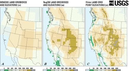
For our study, we use a 2 X CO2 climate simulation (Giorgi, Shields-Brodeur, and Bates, 1994) conducted with the GENESIS AGCM, developed at the National Center for Atmospheric Research (NCAR), to provide estimates of environmental sensitivity to global warming. The output from these simulations is on a rectangular grid of 4.4o of latitude by 7.5o of longitude--a coarse resolution for regional-scale analyses. To achieve finer resolution, we used results from a companion simulation conducted with the NCAR regional climate model (RegCM) with a 60-km by 60-km grid (Giorgi, Shields-Brodeur, and Bates, 1994). The RegCM simulation was initialized and driven with boundary conditions derived from the GENESIS simulation. The landscape of the Western United States is dominated by a great number of mountain ranges, with the highest peaks reaching more than 4,000 m in elevation. The coarse resolution of the GENESIS AGCM portrays the topography of the Western United States as dome-like, with a very flat slope with a maximum elevation of less than 3,000 m centered over Utah and Colorado (fig. 1A, table 1). At the 60-km resolution of the RegCM (fig. 1B), the basin-and-range topography begins to emerge and the Sierra Nevada, Rocky Mountains, and intermountain plateaus are discernible. However, compared with the actual topography at 15-km resolution (fig. 1C), much of the detail is still missing. We use output from the RegCM simulation to drive hydrological and vegetation models to quantify fine-scale environmental responses to global climate change. We are not predicting the exact nature of future climatic changes in the Western United States; rather, our objective is to demonstrate how the effects of large-scale simulations of global climatic change can be portrayed on a spatial scale that is meaningful to society.
1Global Change and Climate History Team, U.S. Geological Survey, Denver, CO. 2U.S. Geological Survey, Corvallis, OR. 3Department of Geogrphy, Universtiy of Oregon, Eugene, OR. 4INSTAAR, University of Colorado, Boulder, CO. | Contents | Top | Next Section |
|
|||||||||||||||||||||||||||||||||||||