
SIMULATED CHANGES IN SURFACE HYDROLOGY
The quantity and quality of water in lakes, reservoirs, streams, and rivers are directly affected by climate and climatic change. Water quantity is determined by net moisture, which, on average, is the difference between what is supplied by precipitation and what is lost to evaporation. Water quality, which is closely associated to water quantity, and climatic fluctuations can affect the temperature and biological and chemical properties of both lakes and rivers.
REGIONAL LAKE RESPONSES
A physically based model of lake temperature and evaporation (Hostetler and Bartlein, 1990) is used to assess the regional and local sensitivity of lakes to climate change. In this experiment, daily averaged meteorological parameters (air temperature, humidity, wind speed, solar radiation, and atmospheric radiation) derived from the RegCM 3-year present-day (control) and 2 X CO2 simulations were used as inputsto the lake model. In response to these initial conditions, the model computes d aily average temperature profiles (i.e., the temperature at each meter of depth within the lake), mixing and stratification, evaporation, and, if applicable, ice and snow thickness.
Regional lake simulations were conducted by sequentially running a lake model at each grid point for the 3-year period, thereby producing a gridded set of simulated lake parameters for the domain. The results presented here are for a hypothetical lake with a surface area of 0.5 km2 (about 125 acres) and a maximum depth of 5 m (about 16 ft), a size that is typical of many of the smaller lakes throughout the West. The distributions of average annual lake-surface temperatures (figs. 4A, 4E, 4I) reflect the topographic and climatological variations simulated across the Western United States by the RegCM. Simulated water temperatures were generally coldest over mountain ranges and the eastern High Plains and warmest in the Southwest and along the Pacific Coast. Temperatures are warmer over the entire domain for the 2 X CO2 simulation (fig. 4I), with the greatest warming occurring over the western High Plains northward into the Canadian prairies. Even though lake evaporation increases for the 2 X CO2 climate, the net moisture (precipitation minus evaporation) computed over lakes is generally higher (fig. 4J) than that calculated for the present-day climate. This increase in net moisture on an annual basis is simulated despite decreases in precipitation and increased temperatures in January and July for the 2 X CO2 climate, indicating that precipitation is increased in months not illustrated in this report. The increased warmth for the 2 X CO2 climate results in a reduction in the number of days that lakes are ice covered in winter (fig. 4K) and the number of days per year that the lakes fully mix (turn over) (fig. 4L). Interpreting these regional patterns at a specific lake is complicated by lake-specific factors such as the actual size of the lake, the shape of the lake basin, and water chemistry.
Where present-day lake temperatures are relatively warm, deep lakes usually mix or turn over during the winter when water temperatures cool to near 4oC and the lake becomes more susceptible to convective and wind-driven mixing. Shallow lakes usually mix more than deep lakes. In warm lakes, it has been demonstrated that increased warming results in more stability and, hence, less opportunity for turnover. Because water chemistry, nutrient flux, and biological activity depend on turnover for mixing and redistribution of important nutrients, warmer waters could reduce or eliminate turnover and thus degrade water quality and biological productivity.
The short growing seasons in colder areas today limit lake productivity--in these areas, warmer water temperatures, reduced seasonal ice cover, and little change or slight increase in the number of mixing days associated with the 2 X CO2 climate would lead to enhanced lake productivity. Water quality and quantity would not be adversely affected by higher water losses to evaporation because net moisture values are generally more positive for the 2 X CO2 climate than they are for the simulated present-day climate.
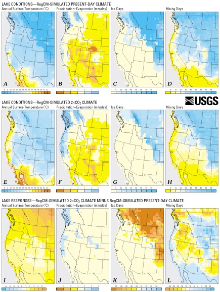
| Figure 4. Maps showing lake conditions under RegCM-simulated present-day climate (A-D), lake conditions under RegCM-simulated 2 X CO2 climate (E-H), and lake responses (lake conditions under RegCM-simulated 2 X CO2 climate minus lake conditions under RegCM-simulated present-day climate) (I-L) for hypothetical lakes (here, a lake with surface area of 0.5 km2 and depth of 5 m). Lake conditions calculated by physically based model of lake temperature and evaporation by Hostetler and Bartlein (1990). Annual surface temperatures for lakes are substantially greater across the region under the 2 X CO2 climate than under the present-day climate, with lake temperatures as much as 5oC warmer on the northern Great Plains (I). Annual precipitation minus evaporation is enhanced across much of the region under the 2 X CO2 climate, but drier-than-present-day conditions are simulated for parts of the southwestern deserts and the Great Plains (J). Ice days are, in general, reduced under the 2 X CO2 climate (K). The total number of days of full-depth mixing shows a complex pattern of response--with increases over most of the Great Plains and in parts of Mexico, the Southwest, and along the Pacific Coast (L). (Click here for scalable 181K PDF version) |
LAKE-SPECIFIC RESPONSES
The lake model described above was applied to Yellowstone Lake, Wyoming, and Pyramid Lake, Nevada--two large lakes of contrasting climatic setting (Hostetler and Giorgi, 1994). For both lakes, 3-year meteorological inputs for the lake model were derived by averaging the output for the four RegCM grid points closest to the lake. Actual depth and areal coverage data for each of the lakes were used in the model runs, which are summarized below.
Yellowstone Lake lies within Yellowstone National Park in northwest Wyoming and is the largest (surface area 360 km2, maximum depth 98 m), high-altitude (2,537 m) freshwater lake in North America. More than 100 tributaries provide water to the lake, which is drained by the Yellowstone River. The lake is relatively cold, covered by ice during winter, and usually turns over before ice forms and after ice melts. The lake is the native habitat of the Yellowstone cutthroat trout (Oncorhynchus clarki bouvieri), which is important both as a source of food for wildlife and as a game fish. The 3-year average surface temperature for ice-free periods is 11.6oC for the simulated present-day (control) climate and 13.2oC for the 2 X CO2 climate (fig. 5A). The lake changes from being predominantly ice covered (196 days of ice cover) under the simulated present-day climate to being predominantly open (152 days of ice cover) under 2 X CO2 climate conditions. The resulting longer growing season, together with increased water supply to the lake (Hostetler and Giorgi, 1994), would lead to increased productivity of the Yellowstone cutthroat trout under the 2 X CO2 climate.
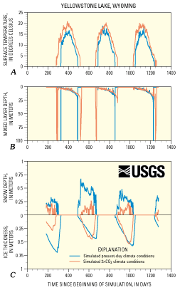 |
Figure 5. Present-day climate (blue) and 2 X CO2 climate (red) simulations for physical characteristics of Yellowstone Lake, Wyoming, during four winters and three summers. Physical characteristics modeled are A, surface temperature; B, mixed layer depth; C, snow depth and ice thickness. When compared to simulated present-day climate conditions, the simulated 2 X CO2 climate results in warmer summer water temperatures (+1.6oC), longer ice-free periods (as illustrated by the times of mixing in this dimictic lake), less snow depth in the winter, and generally thinner winter ice. (A dimictic lake has two turnovers or periods of mixing per year.) (Click here for scalable 39K PDF version) |
In contrast to Yellowstone Lake, Pyramid Lake is a warm, monomictic (i.e., ice free, with one period of turnover annually), closed-basin (no river outflow) lake located at an altitude of 1,065 m in the high desert that lies within the Paiute Indian Reservation in the lee of the Sierra Nevada. The lake is the native habitat of the Lahontan cutthroat trout (Oncorhynchus clarki henshawi) and the cui-ui sucker (Chasmistes cujus), which are important economic and cultural resources for the Paiute Tribe. The average surface temperature of Pyramid Lake over the 3-year present-day (control) simulation is 12.7oC, compared to 15.5oC under the 2 X CO2 climate simulation. The depth of the mixed layer of Pyramid Lake varies seasonally, with turnover occurring in January. Under modeled present-day (control) conditions, turnover of the lake occurred in January for each of the 3 years of simulation (fig. 6); however, under the 2 X CO2 climate simulation, turnover did not occur in any of the 3 years as a result of warming in the upper 30 m of the lake's waters. The average annual evaporation rate computed for the 2 X CO2 climate (1,595 mm) is 14 percent higher than that calculated for the modeled present-day climate. However, as in the case of Yellowstone Lake, increased precipitation in the 2 X CO2 climate simulation resulted in a net increase in moisture over the lake. The lack of turnover under the 2 X CO2 simulation would result in reduced productivity, which could have large negative effects on the fish populations in the lake.
| Figure 6. Present-day climate (blue) and 2 X CO2 (red) simulations for physical characteristics of Pyramid Lake, Nevada, during four winters and three summers. Physical characteristics modeled are A, surface temperature; B, mixed layer depth. The simulated 2 X CO2 climate results in warmer summer water temperatures than under simulated present-day climate conditions (+2.8oC). Part B of the figure shows that, for this lake, warmer water-surface temperatures (predicted by simulated 2 X CO2 climate conditions) have led to a cessation of the overturning process, which would affect the chemistry and biology of the lake. (This has changed the lake from a monomictic lake--one with one yearly turnover or period of mixing-into a lake with no turnovers or periods of mixing.) (Click here for scalable 35K PDF version) | 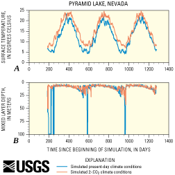 |
STREAMFLOW
Streamflow models are still under development, generally stream-specific, and not yet capable of being applied on a regional scale. In addition, in some areas a substantial portion of river water is derived from ground water, and ground-water flow models are difficult to implement in the Western United States where complex topography and geology determine recharge areas and subsurface flow patterns. Nonetheless, it is still possible to demonstrate the potential sensitivity of specific streams to climate change, such as at Steamboat Creek, Oregon, which lies in a forested watershed on the western slope of the Cascade Mountains. Steamboat Creek and its tributaries provide important spawning and rearing habitats for native steelhead trout (Oncorhynchus mykiss). During part of July and August, present-day average maximum stream temperatures are often near the upper limit of tolerance (24oC) for juvenile steelhead trout (fig. 7).
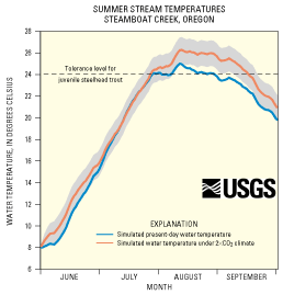 |
Figure 7. Simulated summer stream temperatures under present-day climate (control, in blue) and simulated temperatures under 2 X CO2 climate (red) of Steamboat Creek, Oregon. The dashed horizontal line at 24oC on the "water temperature" axis indicates the summer temperature tolerance limit of juvenile steelhead trout (Oncorhynchus mykiss). Under the 2 X CO2 climate simulation, the statistical model of Hostetler (1991) suggests that the length of time within the year when the tolerance limit is exceeded is more than twice as long as under simulated present-day climate conditions (control). Shaded area surrounding 2 X CO2 temperature curve indicates one standard deviation (sigma) from the mean. (Click here for scalable 14K PDF version) |
A statistical model of stream temperature (Hostetler, 1991) provides quantitative estimates of the change in summer water temperatures in this stream in response to climate simulated by RegCM. Although the annual average air temperature of the Steamboat Creek drainage was only about 1oC warmer for the simulated 2 X CO2 climate than for the control case (RegCM-simulated present-day conditions) (fig. 8), it was as much as 3C warmer during the minimum flows of the summer. Precipitation increased 25 percent annually for 2 X CO2 climate relative to simulated present-day conditions. As a result of this increase in precipitation and change in air temperature, streamflow increased and is shifted slightly seasonally (fig. 8C). During summer, the effect of higher air temperatures on water temperatures was not offset by increased flow and maximum stream temperaturesstream water temperatures calculated for the 2 X CO2 climate exceeded the tolerance level of steelhead trout for a period more than twice as long as the simulated present-day average (fig. 7). Relatively small changes in climate could thus lead to significant degradation of spawning habitat. The potential for natural warming implies that, if the steelhead trout's habitat is to be maintained, land-use decisions in the Steamboat Creek basin will need to be based on extensive analysis of the effects of both natural climate variability and human modifications.
| Figure 8. Comparisons of present-day (control, in blue) and 2 X CO2 (red) air temperature (A), precipitation (B), and streamflow (C) simulations of Steamboat Creek, Oregon. In this case, the simulated annual air temperature of the drainage rises only 1oC. However, the simulated air temperature during the summer period of minimum flow is 3oC higher in the 2 X CO2 simulation than in the control simulation. The 2 X CO2 simulation has higher precipitation levels than in the control simulation-hence, streamflow increases under the 2 X CO2 simulation and shifts slightly seasonally. The change in streamflow lags the temperature and precipitation changes by a month or more, probably due to the time required for soil moisture to respond to changes in climate.(Click here for scalable 18K PDF version) | 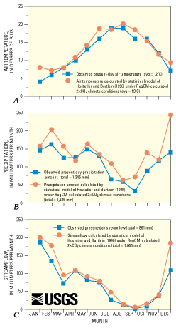 |
| Contents | Top | Previous Section | Next Section |
| AccessibilityFOIAPrivacyPolicies and Notices | |
| |
|