![]()
In the Central Columbia Plateau, 84 percent of drinking water comes from ground water. Both public supply and domestic water systems depend largely on ground water [5, 6] (fig. 5). Current nitrate data are generally available for public supply wells, which must be sampled regularly. Domestic wells, however, are generally sampled only for special studies. About 20 percent of wells in the Study Unit exceed the MCL for nitrate in drinking water [1, 7]; the MCL is set by the U.S. Environmental Protection Agency at 10 milligrams per liter (mg/L) [8]. Reducing nitrate in ground water has been the focus of cooperative efforts between Federal, State, and local agencies.
Nitrate concentration has been suggested as an indicator of overall ground-water quality [9, 10], and drinking water with high nitrate concentrations is a potential health risk, particularly for infants [7, 8, 11].
Table 2. Percentage of drinking water wells sampled in 1985-96 with nitrate concentrationsa exceeding the U.S. Environmental Protection Agency maximum contaminant level of 10 milligrams per liter [--, insufficient data; %, percent]
a For wells sampled more than once, the most recent value was used. b 411 public water systems with at least 15 hook-ups; average depth 270 feet [9]. c 270 public water systems with less than 15 hook-ups; average depth 210 feet. d 67 domestic wells sampled for the NAWQA Land Use Study component (p. 24); average depth 140 feet [3]. e Percentages were not calculated for counties that fall partly outside the study area. f Most wells are deep, averaging 500 feet (see Moses Lake area, fig. 6).
The Columbia Basin Irrigation Project brings more than 2,500,000 acre-feet (800 billion gallons) of water per year from the Columbia River to the Quincy-Pasco subunit, enabling intensive irrigated agriculture.
In much of the North-Central subunit, deep ground water is the only source of water. Most of this subunit's high nitrate concentrations are in the shallower wells bordering the Quincy-Pasco subunit.
The Palouse subunit, dominated by nonirrigated agriculture, has generally lower nitrate concentrations than the rest of the Study Unit.
 (22,486 bytes)
Figure 6. Most public supply wells [13] and domestic wells that exceed the maximum contaminant level (MCL) for nitrate are in the Quincy-Pasco subunit. (Wells were sampled from 1985 to 1996; for wells sampled more than once, the most recent value was used.)
Synthetic fertilizers became widely available after World War II. Fertilizers are the source of 84 percent of nitrate inputs to the Central Columbia Plateau [16]. Other sources of nitrate include cattle feedlots, food processing plants, septic tanks, and treated wastewater; these are local and thus less important sources in most of the Study Unit.
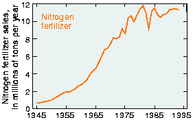
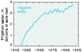
Agricultural acreage continues to increase in the plateau, but nationally recommended application rates for fertilizer have been lowered in the last few years. As a result, fertilizer sales (fig. 7) and application have leveled off [12]. Irrigation, however, continues to increase in the plateau [fig. 8].
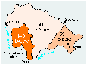
Two primary factors contribute to the Quincy-Pasco subunit's high nitrate concentrations: high rates of fertilizer application [fig. 9] and irrigation water. Ninety-four percent of all the water used in the plateau supports agricultural irrigation in the arid Quincy-Pasco subunit [5]. This extensive irrigation has greatly increased rates of recharge (fig. 10), which is water moving from the land surface to ground water. Recharge, especially at higher rates, moves nitrate into shallow ground water.
|
Figure 7. Sales of nitrogen fertilizer in the United States have leveled off [14, 15]. Graph modified from [12]. |
Figure 9. Annual application rates of nitrogen fertilizer are highest in the Quincy-Pasco subunit (rates are in pounds per acre (lb/acre)), (1991 data shown) [16]. |
|
Figure 8. The amount of irrigation water diverted from the Columbia River has steadily increased [16]. |
Figure 10. Average rates of recharge are highest in the Quincy-Pasco subunit (rates are in inches per year (in/yr)) [17]. |
Nitrate concentrations in the Central Columbia Plateau's ground water have generally increased since the 1950s. Although fertilizer application leveled off in about 1985, it is too early to be certain of any corresponding leveling off or decrease in nitrate concentrations in the regional ground-water system.
Individual wells may show trends that reflect only local conditions. For example, at Ringold Springs, one of the largest springs in the Study Unit, nitrate concentrations may have leveled off. However, the improvement is probably not as dramatic as is suggested by the decrease shown in figure 11.
Across the plateau, nitrate concentrations continue to increase in most areas. Examples of varying nitrate trends in ground- and surface-water systems are discussed on page 9.
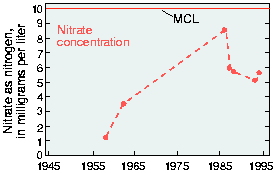
Figure 11. Nitrate concentrations may have leveled off at Ringold Springs, a large spring in the Study Unit (site A, fig. 14), from 1957 to 1994 [18]. However, data are limited and the peak concentration in 1986 may have been unusual.
Trends in individual wells may not reliably represent trends for a large area. In the Quincy-Pasco subunit, samples from springs and surface-water sites can give further insight into trends and variability of nitrate in ground water.
In the Quincy-Pasco subunit, nitrate concentrations in ground water can be much higher during the irrigation season (fig. 12). In some parts of the subunit, however, low-nitrate water leaking from irrigation canals may dilute nitrate in ground water, so that summer concentrations are close to naturally occurring levels (2-3 mg/L) [12].
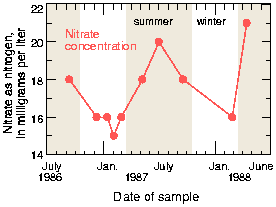
Figure 12. In a well in western Franklin County (site B, fig. 14), nitrate concentrations are higher during the peak irrigation season (Mar.-Oct.) [18].
The average nitrate concentration in regional shallow ground water is 6 mg/L or more. In fresh water diverted from the Columbia River for irrigation, nitrate concentrations are 1 mg/L or lower. As shown in figure 13, some wells close to canals have below-average nitrate concentrations due to dilution by water leaking from canals [18].
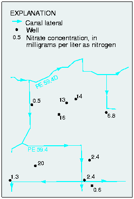
Figure 13. In an irrigated area in western Franklin County (area C, fig. 14), PE 59.4 Lateral has a nitrate concentration of 1.3 milligrams per liter. Most wells close to the canal have lower nitrate concentrations [18].
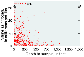
Deeper ground water, which is farther from sources of nitrate applied on the land surface, is less susceptible to contamination. Also, when irrigation raises the water table significantly, as has occurred in the Quincy-Pasco subunit, recently recharged ground water flows rapidly to surface waters instead of to deeper ground water. This prevents some of the nitrate present in recently recharged ground water from moving to deeper ground water. Figure 15 shows that nitrate concentrations are generally lower at greater depths. Many public supply wells are relatively deep, so have lower nitrate concentrations and exceed the MCL less frequently than do the shallower domestic wells (table 2).
|
Figure 14. Sites in the Quincy-Pasco subunit (also the Columbia Basin Irrigation Project area) used to describe trends in nitrate concentrations. |
Figure 15. Nitrate concentrations are lower at greater depths; however, in irrigated areas (see fig. 14) some deep wells have elevated nitrate concentrations. |