
MAJOR FINDINGS—Continued
Pesticides in the Upper Tennessee River Basin
 |
| Pesticides are widely used in the Upper Tennessee Basin for control of insects, fungi, weeds, and other undesirable organisms. |
Pesticides are widely used in the Upper Tennessee River Basin to control insects, fungi, weeds, and other undesirable organisms. These compounds vary in their toxicity, persistence in the environment, and transport characteristics. Use of some of the more persistent organochlorine compounds, such as DDT, chlordane, dieldrin, and aldrin has been discontinued in the United States, but their residues are still detected in the environment. Although pesticides usually are applied to specific areas and directed at specific organisms, these compounds often become widely distributed and pose hazards to nontarget organisms. Of 18 sites sampled for organochlorine residues in bottom material and biota in the Upper Tennessee River Basin, chlordane was detected at three sites and dieldrin and DDT-related residues at two sites.
Pesticides were Frequently Detected in Surface Water
Pesticide use in the Upper Tennessee River Basin is primarily for agricultural purposes. Herbicides, including atrazine and its degradation product, deethylatrazine, had some of the highest application rates and were also among the most frequently detected pesticides in the basin. Herbicides were detected in 98 percent of the 428 surface-water samples collected; atrazine was found in 91 percent and deethyl-atrazine in 86 percent. Metolachlor and simazine were detected in 62 and 40 percent, respectively. Tebuthiuron and prometon, which are used most commonly in noncrop areas, were also among the most frequently detected herbicides (in 58 and 31 percent of the samples collected, respectively). The most frequently detected insecticides were diazinon (12 percent), carbaryl (10 percent), and chlorpyrifos (10 percent), all of which are used on a variety of crops to control pests.
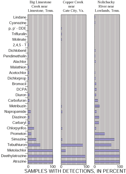 |
| Figure 21. Pesticide detections at three agriculturally dominated sites followed similar patterns. |
Detection frequencies for 27 pesticides detected at 3 intensively sampled agricultural sites in the Upper Tennessee River Basin (fig. 21) generally illustrate the results obtained at all 13 Basic Fixed Sites from which surface-water samples were collected. Overall, a total of 32 pesticides were detected. Chlorothalonil, alpha-BHC, and terbacil each were detected once and etho-prop was detected twice.
Some differences among the three sites are notable and probably reflect different agricultural practices and hydrologic conditions. For example, at the Nolichucky River site, compounds generally not found at other sites such as cyanazine, alachlor, DCPA, metribuzin, bromacil, and diazinon, were detected. Molinate, trifluralin, and p,p-DDE were detected only at the Copper Creek site, which also had a significantly higher frequency of detection for tebuthiuron. Pesticide detection frequencies at Big Limestone Creek and the Nolichucky River were, as expected, similar for several compounds . including metolachlor, simazine, prometon, and napropamide. Big Limestone Creek is a tributary to the Nolichucky River, and both drain the same general agriculturally dominated area. The Big Limestone Creek drainage basin, however, contains more dairy operations than other parts of the Nolichucky drainage basin, which may account for some of the differences between the two sites.
| Table 1. Major pesticides used in the Upper Tennessee River Basin, listed in order of estimated total pounds of active ingredient applied annually (1991-94) (18) |
||
| Insecticides |
Herbicides |
Fungicides |
| Oil .....................256,000 |
Atrazine ............. 116,000 |
Methyl bromide....423,000 |
| Acephate .............80,700 |
2-4-D ................... 55,600 |
1-3-D ................. 342,000 |
| Chlorpyrifos...........71,500 |
Metolachlor .......... 46,300 |
Captan.. ............ 108,000 |
| Carbaryl................27,200 |
Alachlor ............... 40,900 |
Ziram .................. 69,500 |
| Fenamiphos......... 17,200 |
Pebulate .............. 31,400 |
Sulfur .................. 58,700 |
| Carbofuran............17,000 |
Pendimethalin ...... 25,200 |
Chloropicrin ......... 45,100 |
| Formetanate.........16,300 |
Butylate ...............24,800 |
Mancozeb ........... 40,400 |
| Azinphos-methyl...14,400 |
Simazine...............23,800 |
Metalaxyl ............ 28,100 |
| Phosmet................9,420 |
Glyphosate............16,100 |
Manab ................ 21,500 |
Mixtures of Pesticides Are Common
Pesticides were seldom detected alone in surface-water samples and usually occurred as mixtures of several compounds. Generally, the effects of pesticide mixtures on biota or humans are not included in water-quality criteria, which are most commonly based on single-species, single-chemical toxicity tests conducted under laboratory conditions. As a result, potential adverse effects on biota may be under-estimated.
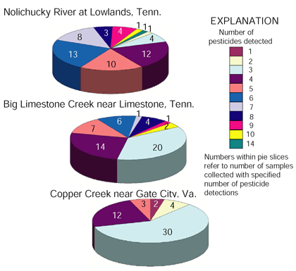 |
| Figure 22. Pesticides usually were detected as mixtures of different compounds. |
Of the 163 samples collected at the three intensive sites, only 2 samples at Copper Creek contained only one detectable pesticide compound, and only 5 total samples contained only two compounds (fig. 22). Among the intensively sampled sites, samples from the Nolichucky River at Lowlands, Tennessee, generally contained more detectable pesticide compounds than samples from the other sites, but usually at lower concentrations. This reflects the larger drainage area of the Nolichucky River (1,687 square miles) as compared to the drainage areas of the other intensive sites (79 and 106 square miles for Big Limestone and Copper Creeks, respectively). Similarly, more pesticides also were detected in samples from Big Limestone Creek, which has a larger percentage of agricultural land use and a greater variety of crops than the Copper Creek Basin in Virginia.
Peak Pesticide Concentrations Are Seasonal
Pesticide concentrations were found to be seasonal and closely related to land use. The highest concentrations occurred in the more heavily agricultural basins in late spring and early summer, coinciding with crop applications. Results of weekly sampling results at the three intensively sampled agricultural sites illustrate the seasonality and short-lived nature of the peak concentrations in streams draining agricultural areas (fig. 23). Peak concentrations coincided with the first substantial runoff event following agricultural applications in May 1996, after which concentrations declined relatively rapidly to near-background levels. Less frequent sampling would have made it less likely to have noted the existence of the peaks. Because these streams are flashy in that peak discharges come and go very quickly, it is possible that even higher concentrations can occur for short periods of time. Seasonality also was evident at sites not characterized or directly influenced by intense agricultural activities. Atrazine and metolachlor concentrations at Clear Creek at Lilly Bridge, a predominantly forested watershed and part of the Obed National Wild and Scenic River watershed, also showed a distinct seasonality but with much lower concentrations (fig. 24). The seasonal pattern at this site is more gradual, suggesting atmospheric input more than runoff from agricultural activity.
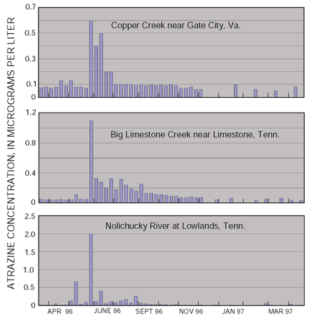 |
| Figure 23. Atrazine concentrations were seasonal in the Upper Tennessee River Basin intensively sampled sites, March 1996 - April 1997. |
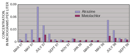 |
| Figure 24. Atrazine and metolachlor concentrations were seasonal in monthly samples at Clear Creek at Lilly Bridge, March 1997 - September 1998. |
Pesticide Concentrations Usually Meet Guidelines
Although most of the water samples collected contained detectable concentrations of one or more pesticides, no concentrations exceeded any drinking-water standards or guidelines. Only 20 of the 31 pesticides detected, however, have established guidelines. Of the 15 compounds that have aquatic-life guidelines, four were detected at concentrations higher than the guidelines. Carbaryl concentrations in excess of the 0.20-µg/L (micrograms per liter) aquatic-life criterion(19) were found in four samplestwo each from the Guest River near Millers Yard, Virginia, and the Nolichucky River at Lowlands, Tennessee (fig. 25). Lindane, an organochlorine used primarily for the protection of tobacco transplants, was above the 0.01-µg/L criterion in three samples from three different sites, two of which were in the same subbasin - Little Limestone Creek and the Nolichucky River at Lowlands, Tennessee. An atrazine concentration higher than the 0.18-µg/L criterion(20) also was detected in one sample taken at the Nolichucky River at Lowlands, Tennessee, in May 1996. This was the only criterion exceedance noted for any herbicide even though herbicides were detected much more frequently than the other pesticide types. One sample collected at the Guest River near Millers Yard, Virginia, contained a diazinon concentration that was not only greater than the aquatic-life guideline of 0.08 µg/L but approached the USEPA lifetime health advisory level of 0.60 µg/L for drinking water.
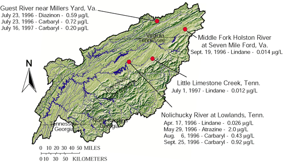 |
| Figure 25. Pesticide concentrations, in micrograms per liter (µg/L), infrequently exceeded aquatic-life criteria in the Upper Tennessee River Basin, 1996-98. |
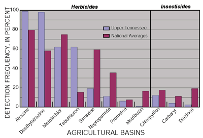
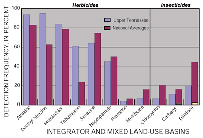
Three herbicides consistently were detected more frequently in the Upper Tennessee River Basin than in other basins across the Nation. Atrazine and deethylatrazine were detected in 99 and 98 percent, respectively, of samples from agricultural basins in the Upper Tennessee River Basin and in 94 and 95 percent, respectively, of samples from mixed land-use basins - significantly more frequently than the national averages of about 80 and 60 percent, respectively. Tebuthiuron also was detected in about 60 percent of the Upper Tennessee River Basin samples as opposed to an overall average of about 20 percent nationally. Detection frequencies for most of the other herbicides probably reflect different herbicide-use patterns in the Upper Tennessee River Basin resulting from particular crop patterns. The three most commonly detected insecticides in the Upper Tennessee River Basin - diazinon, carbaryl, and chlorpyrifos - were detected less frequently than the national averages in all land-use categories. |

Pesticides Were Detected at Low Levels in Ground Water
 |
| Pesticides were detected more frequently in Upper Tennessee River Basin springs than in other sources of ground water. |
Pesticides were detected in Upper Tennessee River Basin ground-water samples more often than not, but generally at concentrations less than 0.01 µg/L. Pesticide concentrations in ground water did not exceed any drinking-water standards or guidelines. Usually, however, pesticides occur in mixtures for which criteria are not available. In addition, 5 of the 11 pesticides detected have no established guidelines or criteria.
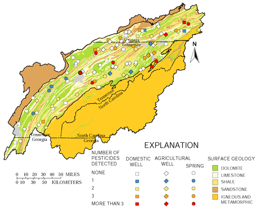
Pesticides were detected in springs significantly more often and in more pesticide detections per sample than in other ground-water sources sampled (fig. 26). This probably reflects the greater vulnerability of springs to surface contamination either from the immediate area or karst features in the carbonate bedrocks. More frequent detections also may reflect the larger drainage areas from which springs capture ground water as opposed to wells. Of the 35 springs sampled, 24 (69 percent) contained detectable pesticide concentrations, and 12 (34 percent) contained detectable quantities of three or more different compounds. Detection frequencies in agricultural and domestic wells, by contrast, were significantly lower and similar to one another; 12 of 30 (40 percent) agricultural wells and 13 of 30 (43 percent) domestic wells contained detectable pesticide concentrations. Of these detections, only three (10 percent) samples from agricultural wells had detections of three or more pesticides. Eight (27 percent) domestic wells, however, had detections of three or more compounds.
 |
| Figure 26. Pesticides were detected at low concentrations in Upper Tennessee River Basin ground water. |
 |
| Figure 27. Pesticides were detected more frequently in springs than in wells in the Upper Tennessee River Basin. |
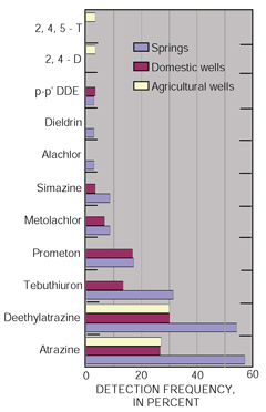
Atrazine and its degradation product, deethylatrazine, were the pesticides most commonly detected in all ground-water samples but were detected twice as frequently in springs as in other ground-water sources (fig. 27). Tebuthiuron, the third most frequently detected pesticide, also was detected more than twice as frequently in springs as in domestic wells. The different pesticide mixtures typical of the agricultural wells sampled reflect the focus on tobacco in this phase of the study. In general, a different suite of pesticides are used for tobacco than for most other crops. For example, atrazine and other broadleaf herbicides are toxic to tobacco.
Volatile Organic Compounds Were Frequently Detected in Ground Water
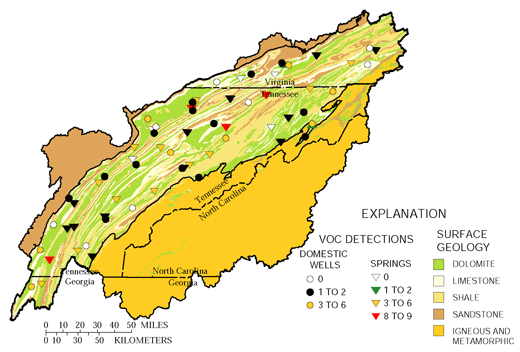
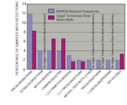
Ground-water samples were collected from 30 domestic wells and 35 springs tapping carbonate strata in the Upper Tennessee River Basin. Volatile organic compounds (VOCs) were detected in most of the ground-water samples (fig. 28) but generally at very low concentrationsoften in orders of magnitude below the established reporting limit. Twenty-eight different VOCs were detected during sampling, 12 of which have drinking-water standards. No measured concentrations, however, exceeded these standards.
VOCs were detected more frequently in springs (86 percent) than in domestic wells (67 percent) and generally at slightly higher concentrations. Of the 20 samples with one or more concentrations greater than 0.1 µg/L, 14 were taken from springs and only 6 from wells. Similarly, of the 28 compounds detected, 22 were detected in spring samples and only 18 were detected in domestic wells.
The most frequently detected VOCs were trichloromethane (51 percent), chloromethane (28 percent), styrene (23 percent), tetrachloroethane (18 percent), carbon disulfide (11 percent), and trichloroethene (9 percent). The remaining 22 compounds were detected in three or fewer samples (less than 5 percent).
Other than the greater detection frequencies for spring samples, no areal or other occurrence patterns could be found. As is the case nationally, the source for many of the most common VOCs detected in ground water, such as trichloromethane, is unclear. The greater occurrence of detections in springs as well as the widespread but random pattern of occurrence suggests the possibility of atmospheric origins, but no definite source can be identified at present.
 |
| Figure 28. Volatile organic compounds (VOCs) are often detected in Upper Tennessee River Basin ground water. |
Detection frequencies in Upper Tennessee River Basin wells for the 10 most commonly detected VOCs nationally were similar to national detection frequencies found for ambient ground water in all land-use settings. All compounds were assessed at a common detection level of 0.1 mg/L. Trichloromethane was the most commonly detected compound nationally as well as in the Upper Tennessee River Basin but typically was detected at concentrations far below drinking-water standards. The results are consistent with the mixed urban and rural land uses surrounding most Upper Tennessee River Basin ground-water sites.
|

Water-Quality Influences of Industry and Mining
Industrial and mining activities prior to the passage of the Clean Water Act in 1972 have left a legacy of contaminated sediment that continues to affect water quality in parts of the Upper Tennessee River Basin. The most widespread contaminants are PCBs (polychlorinated biphenyls) and mercury, mostly from industrial activities dating from 1950 to1972. Sources for some of the other contaminants, however, such as those affecting the Pigeon and Ocoee Rivers date back as far as 1908 and 1843, respectively.
Mercury in the North Fork Holston River is a result of the operation of a chlor-alkali plant on the banks of the river from 1950 through 1971. An estimated 75 pounds of mercury per day were discharged either directly to the river or into unlined holding ponds along the riverbank.(21) Although soils at the site have been remediated, the site continues to discharge mercury.(22) Bed-sediment and tissue samples taken from the Holston River system (fig. 29) were the only samples taken during the study that were above the Canadian guideline for aquatic-life protection (0.486 micrograms per gram total mercury). Although tissue samples in the main-stem Holston River site at Surgoinsville were free of mercury, the bed-sediment results suggest that mercury may be migrating farther downstream than previously thought and may eventually reach Cherokee Reservoir.
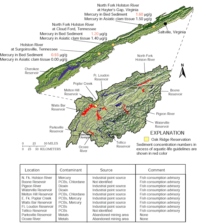 |
| Figure 29. Mercury, in micrograms per gram, and organic contaminants persist in bed sediments and biological tissues in parts of the Upper Tennessee River Basin. |
Mercury is also a major contaminant in the drainages downstream from the Department of Energys 35,585-acre Oak Ridge Reservation (ORR), such as East Fork Poplar Creek, the White Oak Creek watershed, and the lower Clinch River - Watts Bar Reservoir. The ORR, established in 1942 as part of the Manhattan Project to develop the atomic bomb, encompasses three major facilities X10, originally for weapons research but now Oak Ridge National Laboratory (ORNL); Y12, for the fabrication of nuclear weapons components; and K25, for uranium enrichment by gaseous diffusion. As a result of these operations, about 527 sites covering approximately 15 percent of the total ORR area have been identified as contaminated with metals, including mercury, radionuclides, a variety of VOCs, and nitrates.(23)
Most of the contamination has remained confined within the ORR, which was added in its entirety to USEPAs National Priorities List in 1989. A number of contaminants, most notably mercury, PCBs, and cesium-137, however, have migrated to downstream areas. The State of Tennessee has posted a fish-consumption advisory for ORR drainages as wells as Watts Bar Reservoir as a result of bioaccumulation of mercury and PCBs in some fish species.
A 1983 inventory estimated that about 2 million pounds (1,088 metric tons) of mercury was lost from operations related to thermonuclear bomb development on the ORR.(24) Most of this mercury is believed to have volatilized into the atmosphere, but much remains within ORR facilities and in Watts Bar Reservoir sediments. Analyses of sediment cores indicate that the highest discharges of mercury and cesium-137 occurred during the 1950s, and that about 76 metric tons of mercury has accumulated in Watts Bar sediments. About 91 percent of the 335 curies of cesium-137 released from the ORR have also been retained by the lake sediments. The concentrations detected are not believed to pose an imminent human health risk, especially if the deep sediments are not disturbed.(25)
Mining of the massive sulfide deposits in the Copper Basin along the Ocoee River began in 1843. Copper was the primary metal extracted, but iron, sulfur, zinc, and small amounts of gold and silver also were produced. Before 1900, Copper Basin was the largest metal-mining district in the Southeast. The last mine was closed in 1987.(26)
High concentrations of sulfur dioxide produced by smelting operations devastated the surrounding environment, resulting in a moonscape of about 25 square miles. Erosion of the area resulted in high sediment and associated metal loads to area streams. Although thousands of acres have been revegetated and the landscape is being slowly transformed back to forest, relatively high metal concentrations remain in the upper reaches of Parksville Reservoir and the Ocoee River.
Discharge of essentially untreated paper-mill effluent to the Pigeon River began in early 1908 and continued until plant improvements were instituted in the 1990s. Dioxins were first detected in fish samples from the river in 1988 (dioxin detection methods were not available until 1985) and became an immediate priority with respect to human health effects.(27) Dioxins have not been detected in recent samples, including bed-sediment and tissue samples taken during the Upper Tennessee NAWQA study. The State of Tennessee, however, continues a precautionary fish-consumption advisory for the Tennessee portion of the river.
Even though discussions regarding the Pigeon River continue between the States of Tennessee and North Carolina, all parties agree that conditions have improved significantly. Once nearly devoid of aquatic life, benthic invertebrate and fish populations in the Tennessee portion of the Pigeon River are showing signs of recovery. Waterville Lake, however, still retains tons of contaminated sediments deposited since the dam became operational in 1930, and these sediments remain a potential source of dioxin and other contaminants.
Polycyclic aromatic hydrocarbons (PAHs) commonly are detected as pollutants in soils and sediments, occur naturally in crude oil and coal, and also can result from the incomplete combustion of fossil fuels and forest fires.(28) In the upper Clinch River Basin, PAH concentrations reflect the presence of coal fines from upstream mining activities.
Twenty-nine PAHs were found in upper Clinch River bed-sediment samples and, with only a few exceptions, were not detected in the 12 samples taken from other parts of the Upper Tennessee Basin. Although PAHs are known to be toxic to fish, mussels, and aquatic insects, sediment-quality guidelines for the protection of aquatic life have been established for only 12 of the compounds detected. Of these, only two compounds naphthalene and phenanthrene exceeded their respective Canadian probable-effect levels of 391 µg/kg (micrograms per kilogram) and 515 µg/kg (fig. 30). The probable-effect levels define concentrations above which adverse effects are expected. A third compound, benzo(a)anthracene, occurred in concentrations very near its guideline of 385 µg/kg, and a number of compounds lacking guidelines were found at concentrations of 1,000 µg/kg or greater.
The highest concentrations generally follow the results for naphthalene and phenanthrene and occurred in the major river sites nearest, on a relative basis, to upstream mining activities. For example, concentrations at the Powell River and Pendleton Island sites exceeded those found at the Clinch River near Tazewell, which is farther removed from active mining in terms of river miles. Higher gradients and water velocities in the tributaries to the major streams prevent the accumulation of fine-grained sediment and coal fines. The main river channels, however, contain large pools and backwater areas where fine-grained material and associated constituents are deposited.
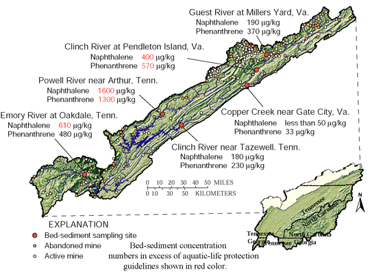 |
| Figure 30. Relatively high polycyclic aromatic hydrocarbon (PAH) concentrations, in micrograms per kilogram, are common in bed sediments in the upper Clinch River Basin. |
 |
| Figure 31. Freshwater mussel species diversity in the Clinch and Powell Rivers, Tennessee and Virginia, 1988-1999. |
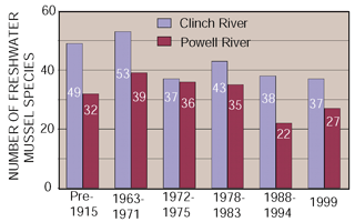
Freshwater Mussels in the Clinch and Powell Rivers
Freshwater mussel species diversity has been slowly declining in the Clinch and Powell Rivers of Tennessee and Virginia over the past 100 years. The numbers of mussel species found in these rivers are shown in figure 31 for selected periods of time and illustrate the long-term trend in loss of species diversity. The numbers do not precisely show numbers of species lost but reflect difficulties in finding specimens as species decline and, in some cases, difficulty with basin access. For example, prior to 1915, the upper parts of the river basins were inaccessible and remained unsurveyed.
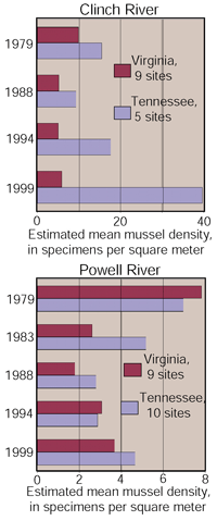 |
| Figure 32. Estimated mean densities of freshwater mussel specimens in the Clinch and Powell Rivers, Tennessee and Virginia, 1979-99.(29) |
Although some forms were lost, survey results from 1963 to 1971 indicate that the fauna survived TVA impoundment largely intact. Mussel declines became apparent, however, in the mid-1970s, and by that time many previously common mussel species had become rare, extirpated, or extinct.
The greatest declines in mussel abundance occurred during the record drought from 1983 to 1988 (fig. 32). Since that time, the Clinch River in Tennessee has shown remarkable recovery, both in mussel densities and species numbers. The Virginia parts of the Clinch and the Powell Rivers, however, have recovered to a only a little more than half the densities recorded in 1979, mostly reflecting recovery of the three most abundant species. Most of the rare and more sensitive species continue to decline in the Powell River and in the Virginia part of the Clinch River.(29)
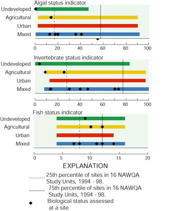
Three biological indicators, which typically respond to changes in stream degradation, illustrate the relation of Upper Tennessee River Basin sites to the overall range of NAWQA sites nationwide. For all indicators, higher values suggest a more degraded stream site. Algal status focuses on the changes in the percentage of certain algae in response to increasing siltation.Within the Upper Tennessee River Basin, the only sites in the highest 25 percent nationally are Big Limestone Creek, which drains predominantly agricultural land use, and the Pigeon River, which has been heavily affected by industrial wastes. Invertebrate status is the average of 11 invertebrate (primarily insects, worms, crayfish, clams) metrics that summarize changes in richness, tolerance, trophic conditions, and dominance commonly associated with water-quality degradation. Among the Upper Tennessee River Basin sites, the two that rank highest on the index are the Pigeon and French Broad Rivers. The Pigeon River is recovering from decades of receiving industrial wastes. The French Broad River is principally affected by urban development in the Asheville, North Carolina, area and agriculture in the lower part of the basin. Fish status is the sum of scores of four fish metrics (percentage of tolerant, omnivorous, non-native individuals, and percentage of individuals with external anomalies) that tend to increase in association with water-quality degradation. The Holston River at Surgoinsville, Tennessee, which ranked highest on this index, is characterized by relatively high concentrations of mercury and copper in bed sediments, probably derived from upstream industrial activities. |

The NAWQA Program, like most water-quality assessments, is designed to gather information on general water-quality conditions and analyze problems that tend to be chronic as opposed to episodic. Even though the NAWQA Program provides for sampling during storm events in order to achieve a more complete picture of water-quality conditions, detection of every instance of water contamnation is clearly beyond the programs defined scope. In general, this is true of every other on-going State or Federal water-quality assessment.
In late May 1996, however, a toxic release was recorded at the Big Limestone Creek site (fig. 33, number 8) that resulted in a fishkill over several miles in the lower end of the stream. The apparent cause was excessive ammonia concentrations that were traced to agricultural activities upstream. If not for the sampling activity being conducted at the site, the kill most likely would have gone unreported. Given the relatively remote nature of many biologically diverse stream reaches in the Upper Tennessee River Basin, it is possible that many similar episodes go unreported as well.
The number of relatively rare and threatened aquatic species in the Upper Tennessee River Basin make accidental spills and releases a particular concern in parts of the basin. Habitat modifications resulting from human activities, such as impoundments and pollution, have restricted the greatest numbers and variety of aquatic fauna to only a few tributaries.(32) In addition, impoundments have effectively separated once contiguous biological communities into smaller, more vulnerable subunits.
The upper Clinch and Powell watersheds are home to the most diverse fish and mussel fauna in the Upper Tennessee River Basin. These two subbasins are effectively separated from biological interaction, however, by Norris Lake and are very vulnerable to coal-fine spills from numerous active and abandoned mining sites in their headwaters. At least five coal-fine spills occurred during the 199599 study period (G. Heffinger, U.S. Fish and Wildlife Service, written commun., April 17, 2000).
Mussel species generally are of the greatest concern because of their lack of mobility and the longer times typically required for populations to recover. For example, data collected in 1971 following a very large 1967 fly-ash spill in the Clinch River found that fish and aquatic insects were reestablished relatively quickly. Mussels, however, have yet to recolonize the 9- to 10-mile reach directly downstream from the spill site.(33)
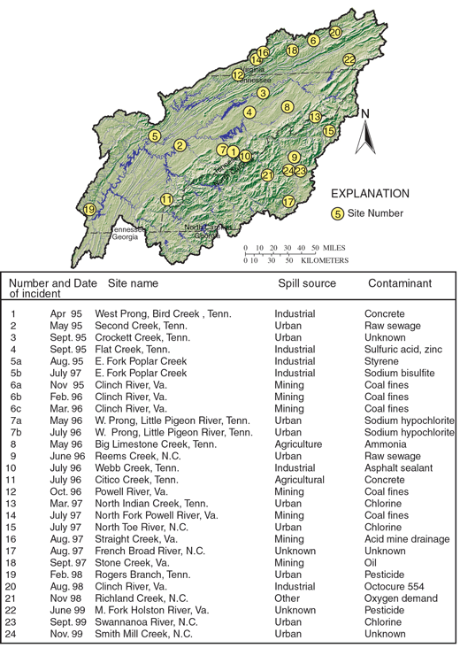 |
| Figure 33. Contaminant releases have resulted in fish and mussel kills in the Upper Tennessee River Basin, 1995-99.(30, 31) |
| Table of Contents || Previous Section || Next Section || Glossary U.S. Geological Survey Circular 1205 Suggested citation:
|
