
SUMMARY OF MAJOR FINDINGS
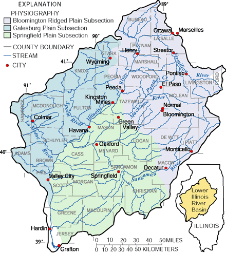 |
| The lower Illinois River Basin occupies approximately 18,000 square miles in central and west-central Illinois. The basin lies almost entirely within the Till Plains physiographic section. The glacial materials account for the flat prairie landscape and the thick, rich soils. The three physiographic subsections influence water quality indirectly by influencing the type and intensity of agricultural activities. [1] |
During the past century, agricultural runoff, channel and drainage modifications, urbanization, and other activities have altered water quality, aquatic biological communities, and aquatic habitat in the lower Illinois River Basin. The water quality of large rivers, such as the Illinois and Sangamon Rivers, was more likely to meet drinking-water standards than water quality of small streams during 199598. In spring, concentrations of nitrateespecially in small streamsexceeded the Maximum Contaminant Level (MCL) of 10 mg/L (milligrams per liter) for drinking water. Some of these streams replenish drinking-water reservoirs. In samples collected during runoff from spring and early summer storms, concentrations of herbicides and a few insecticides exceeded drinking-water standards or guidelines to protect aquatic life. In a few samples from small streams, concentrations of commonly used agricultural pesticides were among the highest nationally. Although most concentrations were low with respect to existing drinking-water standards or guidelines, criteria for the protection of human health or wildlife have not been established for more than one-half of the chemicals detected.
- Nitrogen and phosphorus concentrations were among the highest in the Nation. The highest concentrations in the basin were found in small streams in agricultural areas. The MCL for nitrate was exceeded in 15 percent of samples from all streams and rivers. The concentration of total phosphorus in most samples (79 percent) from all streams and rivers exceeded the 0.1-mg/L guideline recommended by U.S. Environmental Protection Agency (USEPA) to prevent excess algal growth in streams. (See pages 68.)
- Nitrate concentrations in the Illinois River at the inflow to the basin (Ottawa) and outflow from the basin (Valley City) were similar; however, approximately twice the amount of nitrogen was transported out of the basin (124,000 tons per year) as was transported into the basin (66,000 tons per year). (See page 6.)
-
During August 1997, concentrations of nitrate in streams were lower in the basin than in other NAWQA study-area streams of the upper Midwest. Algal communities may have incorporated much of the instream nitrogen, resulting in lower nitrate concentrations in the water during late summer. (See pages 710.)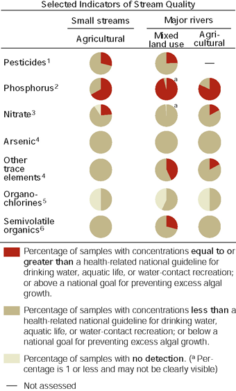
- Three herbicides commonly used by farmers to protect corn and soybean cropsatrazine, metolachlor, and cyanazinewere detected in every sample collected during 199598. During periods of spring runoff, these herbicides exceeded drinking-water standards or guidelines or aquatic-life guidelines. Another herbicide, acetochlor, was detected in most samples (81 percent). (See pages 1217.)
- Pesticide breakdown products were detected much more frequently than the parent compound, and generally at higher concentrations and for a longer period of time after application. (See pages 1617.)
- Organochlorine compounds (including insecticides no longer used) were detected in fish tissue and sediment, and polycyclic aromatic hydrocarbons were detected in sediments at levels of concern. (See pages 1722.)
- The biological communities of streams in the basin comprised many organisms that are tolerant of poor water quality; however, some high-velocity streams had fairly diverse invertebrate communities. (See pages 2021.)
Trends in stream-water quality
For decades, fertilizers and many pesticides have been applied to crops and land. The persistence of pesticides and breakdown products in the soil, water, and sediment within a watershed is not well understood. Concentrations of the herbicides alachlor and cyanazine, however, decreased from the 199192 period to the 199698 period in the Illinois River because of reduced application rates since the early 1990s. (See page 16.)
| Major influences on streams and rivers
|
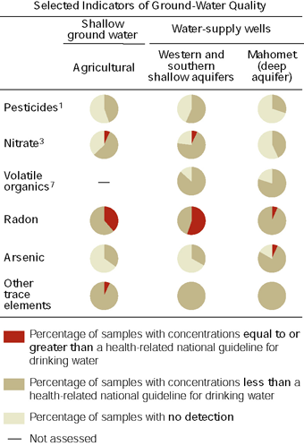
In contrast to the water quality of streams and rivers in the basin and the quality of ground water in other areas across the Nation, agricultural chemicals in ground-water samples from shallow monitoring wells (generally less than 100 feet deep) and drinking-water wells only rarely exceeded the nitrate MCL. Except for radon and nitrate, shallow ground water in the lower Illinois River Basin generally met drinking-water standards or guidelines. Except for radon and arsenic, the water quality in the Mahomet aquifer (greater than 200 feet deep) meets all drinking-water standards or guidelines.
- Major corn and soybean herbicides were not as frequently detected in ground-water samples as they were in stream-water samples. No ground-water sample exceeded drinking-water standards or guidelines for pesticides. (See page 17.)
- Naturally occurring arsenic exceeded the current MCL of 50 µg/L (micrograms per liter) in 2 of 30 wells sampled in the Mahomet aquifer, a major drinking-water source. If the MCL is lowered to 5 µg/L, as proposed by the USEPA, samples from 60 percent (18 of 30) of the domestic (private household) and public-supply (publicly owned wells generally serving a community) wells sampled would probably exceed the lower standard. (See page 22.)
- Geologic materials underlying the basin indicate that it is an area of potentially high radon concentrations in ground water. In about one-half of the samples of shallow ground water, radon exceeded the proposed MCL of 300 pCi/L (picocuries per liter). Only 2 of 30 samples from the Mahomet aquifer exceeded the proposed radon MCL. (See pages 2324.)
- Volatile organic compounds (VOCs) were detected in samples from 83 percent of shallow domestic and public-supply wells, but no samples exceeded drinking-water standards or guidelines. VOCs were detected in 80 percent of samples from the Mahomet aquifer but at concentrations near the method detection limit and well below drinking-water standards and guidelines. (See page 24.)
 |
| Major influences on ground water
|
| Table of Contents || Previous Section || Next Section || Glossary U.S. Geological Survey Circular 1209 Suggested citation:
|
