D
Previous Section: Status of Water-Level Data-Collection Programs
Next Section: Challenges and Future Opportunities
Return to Table of Contents
Return to Home Page
The severe drought of the 1930’s in much of the United States created widespread concern that declining water levels in wells and diminished flow of springs may be warnings of the eventual exhaustion of the Nation’s ground-water supplies. During the drought years of the 1930’s, considerable interest arose in the establishment of systematic programs for monitoring water levels in observation wells. It is instructive to compare the status of water-level monitoring during the 1930’s, during the 1950’s (a second severe drought period), and today at the beginning of the 21st century.
1930’s—In 1933, about 3,000 observation wells were being measured periodically by the USGS and by State agencies, and about 115 of these wells were equipped with automatic (continuous) water-level recorders. Records of water levels covering many years were available for only a few areas, notably southern California, Honolulu, the Roswell Basin in New Mexico, and Long Island, New York. Other areas of heavy withdrawals had more sporadic water-level records. In 1936, the USGS released the first annual report on the fluctuations of ground-water levels and artesian pressures in the United States (Meinzer and Wenzel, 1936). This report was envisioned “as a step in the realization of a nationwide program of water-level records.” At the time, it was noted that the availability of water-level records was dependent upon ongoing investigations and that some of the most valuable records were in danger of being discontinued because of lack of funds for the projects that supported the monitoring. The need also was expressed for more observation wells outside of areas of major ground-water withdrawals to provide information on the effects of climatic variations on water levels. In addition, increased automatic monitoring of water levels was recommended.
1950’s—Ground-water levels at the end of 1954 were at or near record lows throughout most of the southern two-thirds of the United States, creating renewed concern about the possible exhaustion of the Nation’s ground-water supplies (Fishel, 1956). Federal, State, and local agencies measured water levels in about 20,000 long-term observation wells across the country with records for many of the observation wells dating back to the 1930’s. Fishel (1956) used water-level records from nine States to illustrate how in most areas the low water levels were largely a function of the dry climate conditions and would recover after the drought ended. Fishel also noted that significant water-level declines in some areas, including “some of the best and most important aquifers,” were caused by large ground-water withdrawals, and that water-level declines in these areas would likely persist or worsen after the drought ended.
Today (2001)—There are on the order of 42,000 long-term observation wells in the United States with 5 or more years of water-level record. These wells are distributed throughout all States, and the level of effort varies greatly among States. No nationwide, systematic water-level monitoring program exists. Observation wells are still largely selected from existing wells that are part of specific studies, and the continuity of records is difficult when studies draw to a close. The ease of making data available on the Internet enhances the value of automatic water-level monitoring beyond that of the previous decades, but automatic measurement of water levels in long-term observation wells remains limited (for example, less than 10 percent of USGS long-term monitoring wells have continuous monitoring). Relatively little long-term monitoring takes place outside of major withdrawal areas. Concerns about the exhaustion of ground-water supplies exist for parts of the United States, but no longer for the Nation as a whole. Concerns about the effects of pumping on surface-water bodies, about water quality, and about the effects of possible climate change on ground-water and surface-water resources are much greater than in the 1930’s and 1950’s.
|
|
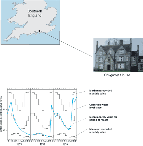
| Ground-water levels have been measured from 1836 to the present on an almost continual basis at the Chilgrove House well in the south of England (Monkhouse and others, 1990). The well is completed in a chalk aquifer, and the hydrologic record for the well represents the longest period of measurement for any well in the United Kingdom. Snapshots of the water-level record for this well show the intensity of drought conditions from 1933 to 1935 in the context of the more than 160 years of record at the site. (Photograph by Terry J. Marsh, Centre for Ecology and Hydrology, Wallingford, England.) |
[an error occurred while processing this directive]