Previous Section: Box C
Next Section: Box D
Return to Table of Contents
Return to Home Page
To aid in preparation of this report, State and local water-resources agencies and USGS District offices were asked to provide information about the design, operation, and history of long-term ground-water observation wells in their respective State. “Long term,” as defined here, refers to any well being used to collect water-level measurements for 5 years or more, or having at least 5 years of hydrologic record. It is worth repeating that water-level measurements typically must be collected from an observation well without interruption over one or more decades in order to compile a hydrologic record that represents the potential range of natural water-level fluctuations and tracks trends over time. Five years is therefore a relatively short period for water-level data collection, but it is at least sufficient to provide a record of several seasons of ground-water-level fluctuations.
Sixty-two State and local water-management or regulatory agencies provided information,
as did USGS offices in all 50 States and Puerto Rico. A surprising revelation
from the results was how difficult it is to obtain information about the actual
number of observation wells monitored, the frequency of water-level measurements,
the average period of hydrologic record, and changes in the monitoring program
over time. The reasons for this varied, but often the ability of the respondents
to provide information was hindered by a lack of formal documentation about
the design of the observation-well networks, limited “institutional memory,”
and the lack of an accessible database. Another common problem encountered was
that responsibilities for collecting water-level data are not always clearly
defined.
The level of effort in collecting long-term water-level data varies greatly
throughout the
United States. Although difficult to define precisely, the information collected
indicated that there
are on the order of 42,000 long-term (5 or more years of record) observation
wells distributed throughout the United States. Approximately 11,000 (less than
one-third) of the reported number of long-term observation wells are presently
monitored through the USGS Cooperative Water Program. This number is significantly
less than the 18,300 long-term observation wells reported in a 1997 inventory
of hydrologic monitoring stations operated under the Cooperative Water Program
(Lew, 1998). The difference between the two numbers,
in part, reflects a difference in the definition of “long-term” observation
wells. However, a continuing decrease in the number of long-term observation
wells monitored under the USGS Cooperative Water Program is consistent with
the national trends noted in the 1997 inventory and in tracking USGS data-collection
activities.
In many States, a lack of sufficient financial resources impedes the construction
of new observation wells in areas of need. To eliminate costs incurred by drilling
and well construction, most agencies use private water wells or existing monitoring
wells for the collection of water-level data. These “wells of opportunity”
are often useful as long-term observation wells, but a problem reported by many
States is the difficulty in locating suitable existing wells in specific aquifers
or geographic locations. Limitations in funding and staffing also impair observation-well
maintenance, upgrades to water-level-monitoring equipment, and consistency in
water-level monitoring activities conducted from year to year.
A proper evaluation of the suitability of existing observation-well networks
is best done at the State and regional level, where the diversity in topographic,
climatic, and geologic settings, ground-water use, and other factors can be
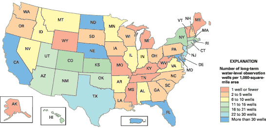
properly considered. Two indicators of the status of observation-well networks
are presented here that may be useful in comparing the approximate magnitude
of long-term observation-well networks by State or region. The first indicator,
observation-well density, is the ratio of the reported number of long-term observation
wells in each State to the area (in 1,000 square miles) enclosed within State
boundaries (Figure 27). The second indicator, which relates
water-level data collection to ground-water use, is the ratio of the reported
number of long-term observation wells to the total amount of ground water withdrawn
(in 100 million gallons per day) from each State (Figure 28).
|
|
| Figure 27. Number of long-term water-level observation wells per 1,000-square-mile area in each State and in Puerto Rico. |
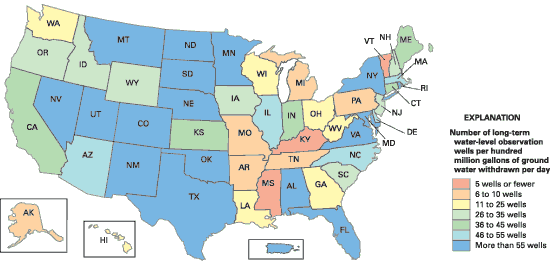 |
| Figure 28. Number of long-term water-level observation wells per hundred million gallons of ground water withdrawn per day in each State and in Puerto Rico. |
The information presented by the maps in Figures 27 and
28 provides some indication of the relative magnitude of
long-term ground-water-level data collection in various parts of the Nation.
The data do not indicate the degree to which observation wells are distributed
geographically and among aquifers in any particular State. Large observation-well
networks in States having comparatively high values of one or both indicators
may be good candidates for network evaluation designed to determine if monitoring
sites may be reduced or redistributed to enhance data collection or reduce operational
costs (see Box C). Conversely, comparatively low values
of one or both indicators generally reflect a sparse number of wells relative
to geographic area or to ground-water use in the indicated State. In these cases,
in particular, a larger number of observation wells may be needed to ensure
that sufficient water-level data are being collected, at a minimum, where ground-water
withdrawals are concentrated or where sensitive environmental areas are located.
As with streamflow and precipitation data, ground-water-level data become increasingly valuable with length and continuity of the records. Yet, unlike streamflow and meteorological records, ground-water-level records in most parts of the Nation are less than 40 years in length. Forty-four percent of agencies reported having observation-well networks in which the typical hydrologic record was 25–40 years, 31 percent reported having observation-well networks in which the typical hydrologic record was 10–25 years, and 2 percent reported having networks in which the typical hydrologic record was less than 10 years. Twenty-two percent of the agencies reported that observation wells in their networks had periods of hydrologic record too varied to characterize.
In recent years, the USGS and many State and local agencies have experienced
difficulties in maintaining long-term water-level-monitoring programs because
of limitations in funding and human resources. Where fiscal or personnel constraints
have forced agencies to revise priorities for environmental data collection,
preference typically has been given to water-quality monitoring, often at the
expense of basic ground-water-level monitoring. Although water-level and ground-water-quality
monitoring are complementary activities, these two types of data commonly are
treated as mutually exclusive, and separate agencies commonly are responsible
for each. Greater attention is needed to the long-term value of water-level
data collected as part of water-quality monitoring and to the potential synergies
between water-quality and water-level-monitoring networks.
Greater attention is needed to the long-term value of water-level data collected as part of water-quality monitoring and to the potential synergies between water-quality and water-level-monitoring networks.
Increased numbers of climate-response observation wells and long-term monitoring of naturally occurring fluctuations in ground-water levels are needed to develop more complete ongoing assessments of droughts and the cumulative effects of other climatic phenomena.
In many States, observation wells tend to be concentrated in areas where aquifers are heavily developed. Few long-term observation wells are intentionally located away from the influence of pumping, irrigation, and other human activities to allow for monitoring of the natural effects of climate variability and to provide baseline data against which ground-water levels monitored during short-term investigations can be better evaluated in a longer term climatic perspective. The U.S. Geological Survey presently operates a sparse national network of about 140 climate-response wells (Figure 29), and a few States have drought-monitoring networks that include climate-response observation wells, such as previously noted for Pennsylvania. Increased numbers of climate-response observation wells and long-term monitoring of naturally occurring fluctuations in ground-water levels are needed to develop more complete ongoing assessments of droughts and the cumulative effects of other climatic phenomena (Alley, 2001). During drought conditions, the effective management of ground-water resources, and monitoring of ground-water availability and ground-water and surface-water interaction, require the ability to rapidly collect water-level measurements and track trends. Therefore, more efforts should be made to construct climate-response and other observation wells capable of collecting “real-time” water-level measurements, and to make all collected water-level data more rapidly and readily accessible through electronic transmittal.
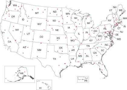 |
| Figure 29. Location of observation wells in the USGS national climate-response ground-water-level network. |
[an error occurred while processing this directive]