 Summary Summary
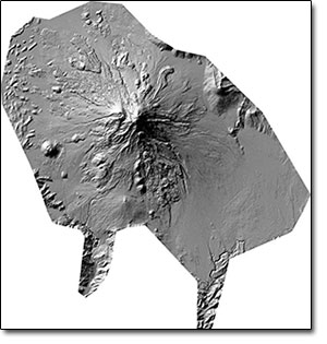
The most voluminous of the Cascade volcanoes, northern California’s Mount Shasta, is a massive compound stratovolcano composed of at least four main edifices constructed over a period of at least 590,000 years. An ancestral Shasta volcano was destroyed by Earth’s largest known Quaternary subaerial debris avalanche, which filled Shasta Valley, northwest of the volcano. The Hotlum cone, forming the present summit, the Shastina lava dome complex, and the Black Butte lava dome on the southwest flank, were constructed during the early Holocene.
As part of the American Recovery and Reinvestment Act (ARRA) of 2009, the U.S. Geological Survey was awarded funding for high-precision airborne lidar (light detection and ranging) data collection at several volcanoes in the Cascade Range. Data collection was arranged by the Oregon Lidar Consortium, administered by the Oregon Department of Geology and Mineral Industries (DOGAMI). The Oregon Lidar Consortium contracted with Watershed Sciences, Inc., to collect 1,220 square km of high-precision airborne lidar data. These data provide a digital map of the ground surface beneath forest cover with horizontal resolution of 1 m (average of 1.82 ground laser returns per square meter) and estimated vertical accuracy of ±4 centimeters (1 sigma), and horizontal accuracies of ±1.5 centimeters. These data will contribute to monitoring and description of natural hazards, the study of regional geology and volcanic landforms, and analysis of landscape modification during and after the next volcanic eruption at Mount Shasta.
Survey Bounding Coordinates:
- West Bounding Coordinate: −122.438774
- East Bounding Coordinate: −121.888382
- North Bounding Coordinate: 41.564495
- South Bounding Coordinate: 41.126339
|
First posted October 31, 2014
Part or all of this report is presented in Portable Document Format (PDF). For best results viewing and printing PDF documents, it is recommended that you download the documents to your computer and open them with Adobe Reader. PDF documents opened from your browser may not display or print as intended. Download the latest version of Adobe Reader, free of charge. More information about viewing, downloading, and printing report files can be found here.
|

