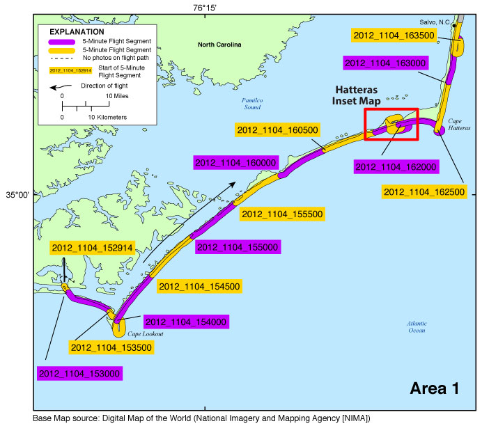
Figure 3a. Map showing the post-Hurricane Sandy coastal oblique aerial survey flight path (USGS field activity 12CCH04) from Cape Lookout, N.C., to Salvo, N.C., on November 4, 2012. The flight path is divided into 5-minute (time) segments and is represented by the alternating purple and yellow lines. Pages containing thumbnail images of photographs, referred to as contact sheets, were created based on these segments. Click on the 5-minute segment name to view each contact sheet. Click on the inset box to view a detailed map of the area.
|
12CCH04 - Area 2 - Rodanthe, N.C., to Cape Henry, Va.

Figure 3b. Map showing the post-Hurricane Sandy coastal oblique aerial survey flight path (USGS field activity 12CCH04) from Rodanthe, N.C., to Cape Henry, Va., on November 4, 2012. The flight path is divided into 5-minute (time) segments and is represented by the alternating purple and yellow lines. Pages containing thumbnail images of photographs, referred to as contact sheets, were created based on these segments. Click on the 5-minute segment name to view each contact sheet. Click on the inset box to view a detailed map of the area.
|
12CCH04 - Area 3 - Cape Charles, Va., to Ocean City, Md.
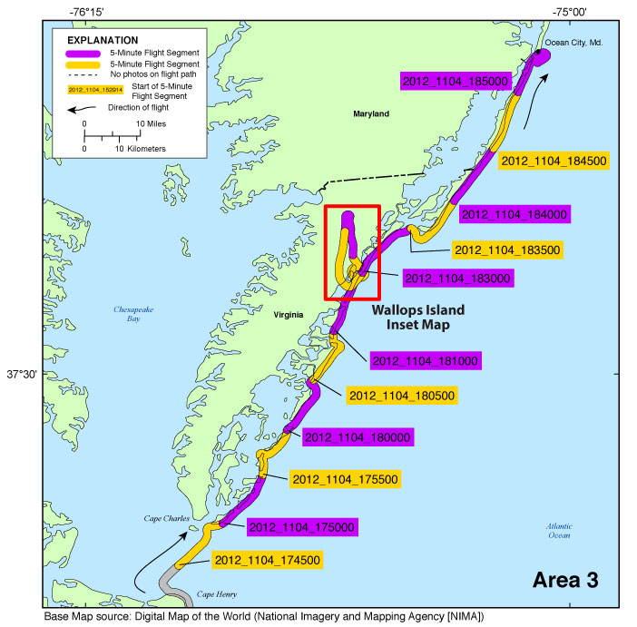
Figure 3c. Map showing the post-Hurricane Sandy coastal oblique aerial survey flight path (USGS field activity 12CCH04) from Cape Charles, Va., to Ocean City, Md., on November 4, 2012. The flight path is divided into 5-minute (time) segments and is represented by the alternating purple and yellow lines. Pages containing thumbnail images of photographs, referred to as contact sheets, were created based on these segments. Click on the 5-minute segment name to view each contact sheet. Click on the inset box to view a detailed map of the area.
|
12CCH04 - Area 4 - Montauk, N.Y., to West Gilgo Beach, N.Y.
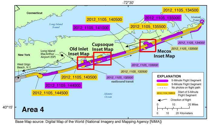
Figure 3d. Map showing the post-Hurricane Sandy coastal oblique aerial survey flight path (USGS field activity 12CCH04) from Montauk, N.Y., to West Gilgo Beach, N.Y., on November 5, 2012. The flight path is divided into 5-minute (time) segments and is represented by the alternating purple and yellow lines. Pages containing thumbnail images of photographs, referred to as contact sheets, were created based on these segments. Click on the 5-minute segment name to view each contact sheet. Click on the inset box to view a detailed map of each area.
Note:
This map shows the survey path on November 5, beginning at Long Island MacArthur Airport, Islip (ISP). The aircraft transited to the coastline and then proceeded along the coast eastbound to the eastern tip of Long Island, Montauk Point. Some imagery was collected during the eastbound transit. Those images are found by clicking on the slightly smaller, italicized segment names. The flight then returned along the coast westbound along the southern exposure of Long Island, then to northern New Jersey, before returning to ISP.
|
12CCH04 - Area 5 - West Gilgo Beach, N.Y., to Seaside Park, N.J.
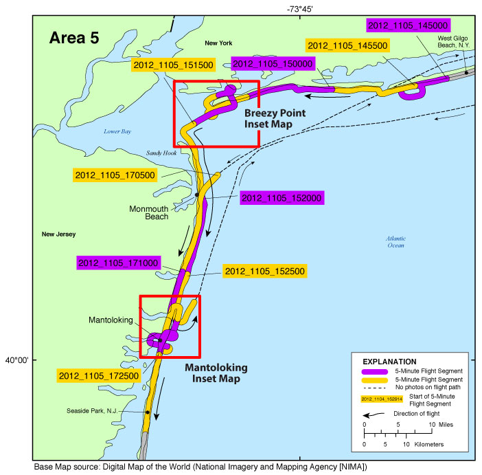
Figure 3e. Map showing the post-Hurricane Sandy coastal oblique aerial survey flight path (USGS field activity 12CCH04) from West Gilgo Beach, N.Y., to Seaside Park, N.J., on November 5, 2012. The flight path is divided into 5-minute (time) segments and is represented by the alternating purple and yellow lines. Pages containing thumbnail images of photographs, referred to as contact sheets, were created based on these segments. Click on the 5-minute segment name to view each contact sheet. Click on the inset box to view a detailed map of each area.
Note: This map shows the survey path on November 5, beginning midway through the first leg of the day's survey. The aircraft surveyed the coast westbound along the southern exposure of Long Island, N.Y., then transited to Sandy Hook, N.J., proceeding southbound to just north of Mantoloking, N.J., before returning to Long Island MacArthur Airport, Islip (ISP). The second leg of the survey left ISP and transited to Monmouth Beach, N.J., then continued south conducting two cross-shore profiles at the breach in Mantoloking. The survey then continued southbound along the shore. |
12CCH04 - Area 6 - Seaside Park, N.J., to Cape May, N.J.
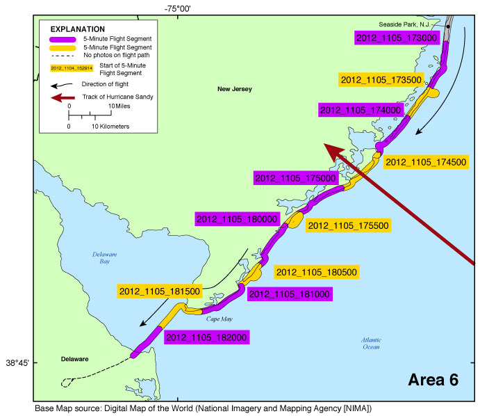
Figure 3f. Map showing the post-Hurricane Sandy coastal oblique aerial survey flight path (USGS field activity 12CCH04) from Seaside Park, N.J., to Cape May, N.J., on November 5, 2012. The flight path is divided into 5-minute (time) segments and is represented by the alternating purple and yellow lines. Pages containing thumbnail images of photographs, referred to as contact sheets, were created based on these segments. Click on the 5-minute segment name to view each contact sheet.
|
12CCH04 - Area 7 - Cape Henlopen, Del., to Cape Charles, Va.
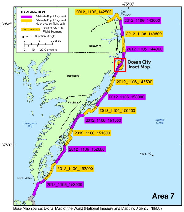
Figure 3g. Map showing the post-Hurricane Sandy coastal oblique aerial survey flight path (USGS field activity 12CCH04) from Cape Henlopen, Del., to Cape Charles, Va., on November 6, 2012. The flight path is divided into 5-minute (time) segments and is represented by the alternating purple and yellow lines. Pages containing thumbnail images of photographs, referred to as contact sheets, were created based on these segments. Click on the 5-minute segment name to view each contact sheet. Click on the inset box to view a detailed map of the area.
|
12CCH04 - Area 8 - Cape Henry, Va., to Oregon Inlet, N.C.
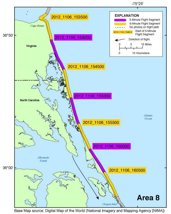
Figure 3h. Map showing the post-Hurricane Sandy coastal oblique aerial survey flight path (USGS field activity 12CCH04) from Cape Henry, Va., to Oregon Inlet, N.C., on November 6, 2012. The flight path is divided into 5-minute (time) segments and is represented by the alternating purple and yellow lines. Pages containing thumbnail images of photographs, referred to as contact sheets, were created based on these segments. Click on the 5-minute segment name to view each contact sheet.
|
12CCH04 - Area 9 - Pea Island National Wildlife Refuge, N.C., to Mullet Cove, N.C.
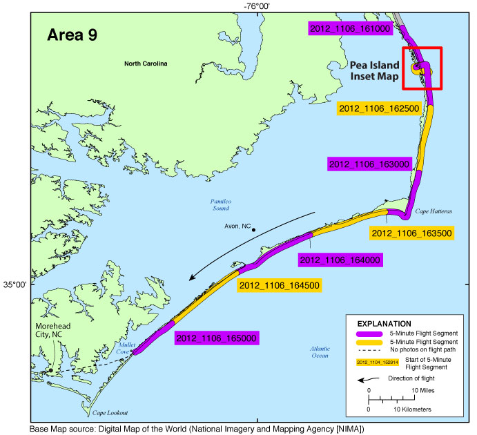
Figure 3i. Map showing the post-Hurricane Sandy coastal oblique aerial survey flight path (USGS field activity 12CCH04) from Pea Island National Wildlife Refuge, N.C., to Mullet Cove, N.C., on November 6, 2012. The flight path is divided into 5-minute (time) segments and is represented by the alternating purple and yellow lines. Pages containing thumbnail images of photographs, referred to as contact sheets, were created based on these segments. Click on the 5-minute segment name to view each contact sheet. Click on the inset box to view a detailed map of the area.
|

