Data Series 901
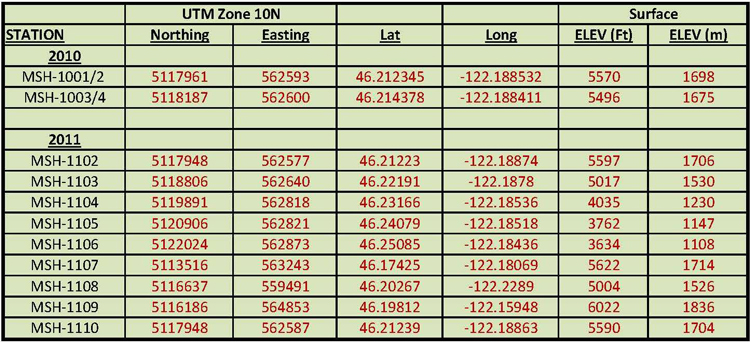
| GPS DataTable 1. GPS coordinates and elevations for the controlled-source audio-frequency magnetotelluric (CSAMT) stations acquired in and adjacent to Mount St. Helens, Washington. (Datum: WGS 84)
NOTES: Coordinates given represent CSAMT receiver locations. The transmitter was always located approximately 250 meters west of the receiver station for consistency. Stations MSH-1001 and MSH-1002 were repeats using the same transmitter-receiver locations. Stations MSH-1003 and MSH-1004 were repeats using the same transmitter-receiver locations. Stations MSH-1001 to MSH-1004 were acquired north of and near the toe of Crater Glacier on September 14, 2010. Stations MSH-1102 and MSH-1110 were acquired on separate days using close but not identical transmitter-receiver locations.Download GPS Data Excel file (38 kb) |

![]() U.S. Department of the Interior |
U.S. Geological Survey
U.S. Department of the Interior |
U.S. Geological Survey
URL: http://pubsdata.usgs.gov/pubs/ds/0901/gps_data.html
Page Contact Information: GS Pubs Web Contact
Page Last Modified: Monday, 28-Nov-2016 20:31:48 EST