Data Series 1045
| IntroductionThe Chandeleur Islands system is an arcuate-shaped group of barrier islands located 40 kilometers (km) offshore of the mainland shore of Louisiana and 120 km due east of the city of New Orleans (fig. 1). The Chandeleur Islands, along with other federally-owned (for example, Breton Island) and State-owned islands (for example, Curlew, Grand and South Gosier) as well as the adjacent estuarine and marine environments comprise the federally-managed Breton National Wildlife Refuge (http://www.fws.gov/breton/). As a means to protect this refuge from the crude oil flowing out of the Macondo Prospect (MC-252) well; following the April 20, 2010, Deepwater Horizon explosion, the State of Louisiana approved construction of an oil-mitigation sand berm along the refuge's outer barrier shoreline. Berm construction took place between June 2010 and March 2011; the well was capped on July 15, 2010. The final constructed berm extended approximately 12–14 km along the northernmost section of the Chandeleur Islands with a width of 100 meters (m) at water level and a height of 2 m above water level (Lavoie and others, 2010). 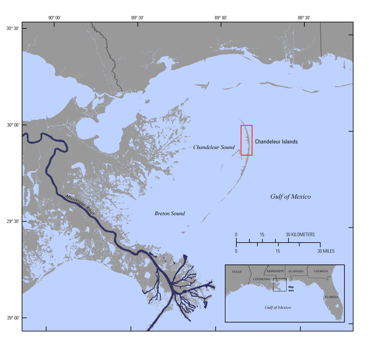 Figure 1. Regional map showing the location of the Chandeleur Islands barrier-island chain in the northern Gulf of Mexico. The study-area extent is indicated by the red box. [Click figure to enlarge] While the oil mitigation potential of the berm was never realized, the berm did provide a potential sediment source to the littoral budget of the Chandeleur Islands and offered an opportunity for researchers to better understand renourishment and perturbation effects on barrier islands over previously unevaluated time scales. Scientists from the U.S. Geological Survey (USGS) St. Petersburg Coastal and Marine Science Center (SPCMSC) developed and implemented a sampling/monitoring strategy for the berm-barrier island system that was part of the Coastal and Marine Geology Program (CMGP) funded Barrier Island Evolution Research (BIER) project. The primary goal of the project, in terms of the berm-barrier island system, was to evaluate the effects of the berm sediment on the Chandeleur Islands system's geomorphic trajectory, including the back-barrier environments (such as tidal flats, salt marshes, and mangrove wetlands). These back-barrier environments often persist during intense oceanographic forcings, including the overtopping that occurred during Hurricane Katrina in August 2005. One objective of the BIER project was to evaluate how these back-barrier environments responded to the berm. This report describes the sediment data from 8 cores collected from back-barrier wetland environments. The sediments were analyzed for various sedimentological and radiometric characteristics to aid in evaluating the berm's impact on the back-barrier environments. The analytical results described in this report can be downloaded from the data downloads page. |

![]() U.S. Department of the Interior |
U.S. Geological Survey
U.S. Department of the Interior |
U.S. Geological Survey
URL: http://pubsdata.usgs.gov/pubs/ds/1045/ds1045_intro.html
Page Contact Information: GS Pubs Web Contact
Page Last Modified: Thursday, 30-Mar-2017 10:18:17 EDT
