Center for Coastal and Watershed Studies
|
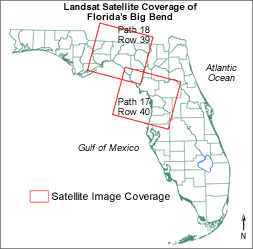
This time series of satellite imagery is a U.S. Geological Survey Data Series release from the Gulf of Mexico and Southeast Tidal Wetlands Project. Each disc in the series represents a portion of the time series and specific Landsat Path and Row acquisition zones. Volume A is the first disc in USGS Data Series 201. This disc contains 19 Landsat Multispectral Scanner (MSS) images of Florida's Gulf Coast, centered on the Big Bend of Florida. Landsat Multispectral Scanner (MSS) and Thematic Mapper (TM) satellite imagery was prepared as a time series for tidal wetlands evaluation. The geo-rectification, enhancement, and normalization of dn (digital number) values was conducted according to methods described in Raabe and Stumpf (1997). The final images have compatible spatial and spectral data to permit inter-scene comparisons. The time series includes MSS for dates between 1973-1987 and TM for dates between 1984-2000. Each multi-band geotiff image file includes a set of processed bands and derived indices for the location and date. Details are described in the metadata file (ds201a_metadata.html or ds201a_metadata.txt). Click an area on the map at right to view image thumbnails. The north area corresponds to Landsat Path 18 Row 39; the south area corresponds to Landsat Path 17 Row 40. (Readme file from DVD-ROM version of this report) |
|

![]() U.S. Department of the Interior | U.S. Geological Survey
U.S. Department of the Interior | U.S. Geological Survey
URL: https://pubs.usgs.gov/ds/2006/201/201a/
Page Contact Information: Feedback
Page Last Modified: December 5, 2006 (JSS, MFD)