USGS, NOAA, FEMA
U.S. Geological Survey
Data Series 236
Version 1.0
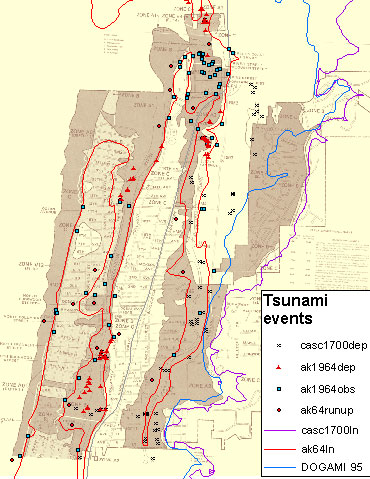
Historic Tsunami Events and FEMA Flood Insurance Rate MapsDeposits from several historic tsunamis in the Seaside area have been identified and mapped (Fiedorowicz, 1997; Jaffe and others, 2004). The locations of samples from the deposits (dot symbols) are compared in this figure with inundation limits for (1) “casc1700ln”, a worst case scenario of a Cascadia subduction zone (CSZ) earthquake (Priest and others, 1997); (2) “ak64ln”, the 1964 Alaskan earthquake tsunami (Horning, Apx. C, Tsunami Pilot Study Working Group, 2006); and (3) “DOGAMI 95”, a limit based on one-dimensional modeling of the CSZ in response to 1995 Oregon Senate Bill 379 (Priest, 1995). The background map is the Flood Insurance Rate Map (FIRM) for Seaside, Oregon (FEMA, 1981).
|
Report Home |
Top | Menu | Abbreviations

![]() U.S. Department of the Interior | U.S. Geological Survey
U.S. Department of the Interior | U.S. Geological Survey
URL: https://pubsdata.usgs.gov/pubs/ds/2006/236/figures/f_histevents.shtml
Page Contact Information: Florence L. Wong
Page Last Modified: Monday, 28-Nov-2016 12:02:15 EST(flw)