USGS, NOAA, FEMA
U.S. Geological Survey
Data Series 236
Version 1.0
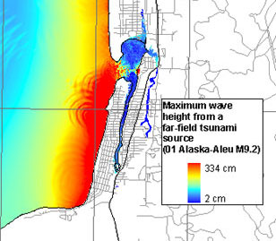
Maximum Tsunami Wave HeightsA, Far-field inundation model result (one of 14) for Seaside, Oregon, based on a magnitude 9.2 earthquake from the Alaskan-Aleutian subduction zone (Titov and others, 2004). Wave height of the maximum wave ranges from 0.02 to 3.34 meters (mean 0.87 m) in the study area.
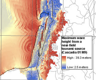
B, Near-field inundation model result (one of 13) for Seaside, Oregon, based on a magnitude 9.0 earthquake from the Cascadia subduction zone (Titov and others, 2004). Wave height of the maximum wave ranges from 2.5 to 39.3 meters (mean 1.1 m) in the study area.
|
Report Home |
Top | Menu | Abbreviations

![]() U.S. Department of the Interior | U.S. Geological Survey
U.S. Department of the Interior | U.S. Geological Survey
URL: https://pubsdata.usgs.gov/pubs/ds/2006/236/figures/f_maxwvht.shtml
Page Contact Information: Florence L. Wong
Page Last Modified: Monday, 28-Nov-2016 12:02:16 EST(flw)