USGS, NOAA, FEMA
U.S. Geological Survey
Data Series 236
Version 1.0
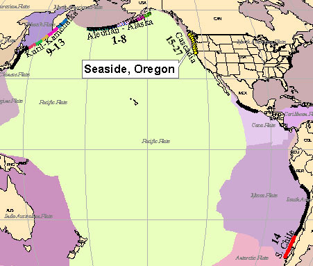
Near- and Far-field Tsunami SourcesFar-field sources used in the tsunami models for Seaside, Oregon, are located in the Kuril-Kamchatka, Aleutian-Alaska, and southern Chile subduction zones. The main near-field source is the Cascadia subduction zone, immediately offshore of Washington, Oregon, and northern California. Numbers identify Facility for the Analysis and Comparison of Tsunami Simulations (FACTS) inundation model runs. Plate boundaries from Coffin and others (1998).
|
Report Home |
Top | Menu | Abbreviations

![]() U.S. Department of the Interior | U.S. Geological Survey
U.S. Department of the Interior | U.S. Geological Survey
URL: https://pubsdata.usgs.gov/pubs/ds/2006/236/figures/f_sourcepac.shtml
Page Contact Information: Florence L. Wong
Page Last Modified: Monday, 28-Nov-2016 12:02:18 EST(flw)