USGS, NOAA, FEMA
U.S. Geological Survey
Data Series 236
Version 1.0
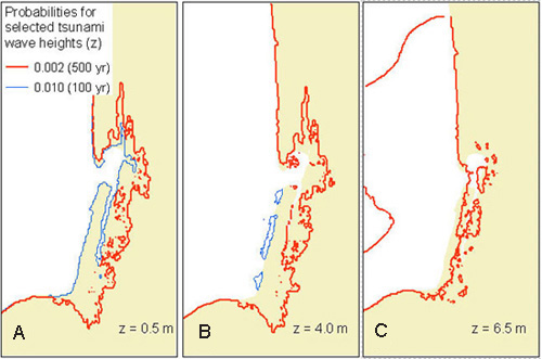
data layers: tsunami flood probability surfacesiyXX_YYg for model numbers XX = 1 to 21 and YY = flood height 0.5 to 10.5 mProbability grids from probabilistic tsunami hazard analysis for selected wave heights (A) 0.5 m, (B) 4.0 m, and (C) 6.5 m with the 0.002 and 0.010 contours where they exist (Tsunami Pilot Study Working Group, 2006).
|
Report Home |
Top | Menu | Abbreviations

![]() U.S. Department of the Interior | U.S. Geological Survey
U.S. Department of the Interior | U.S. Geological Survey
URL: https://pubsdata.usgs.gov/pubs/ds/2006/236/figures/iygridcont.shtml
Page Contact Information: Florence L. Wong
Page Last Modified: Monday, 28-Nov-2016 12:02:19 EST(flw)