USGS, NOAA, FEMA
U.S. Geological Survey
Data Series 236
Version 1.0
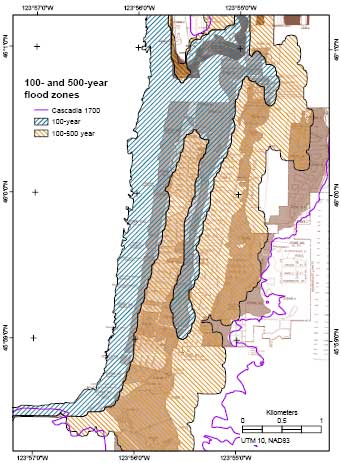
data layer: probzonesMap of 100- and 500-year flood zones based on probabilistic tsunami hazard analysis (PTHA) overlaid on Federal Emergency Management Administration (FEMA) Flood Insurance Rate Maps for Seaside-Gearhart area (Tsunami Pilot Study Working Group, 2006). Seaward limit is mean lower low water (NAVD88, Venturato, 2005). Landward boundary of 500-year flood zone may extend eastward because maximum wave height is 2.5 m at eastern edge. Line showing extent of deposits from tsunami generated by 1700 Cascadia earthquake (Priest and others, 1997) is included for comparison. |
Report Home |
Top | Menu | Abbreviations

![]() U.S. Department of the Interior | U.S. Geological Survey
U.S. Department of the Interior | U.S. Geological Survey
URL: https://pubsdata.usgs.gov/pubs/ds/2006/236/figures/probzones.shtml
Page Contact Information: Florence L. Wong
Page Last Modified: Monday, 28-Nov-2016 12:02:23 EST(flw)