U.S. Geological Survey Data Series 291
1ETI, St. Petersburg, FL 33701.
2U.S. Geological Survey, St. Petersburg, FL 33701.
U.S. Department of the Interior
U.S. Geological Survey
Florida Integrated Science Center - St. Petersburg
Publications are available from USGS Information Services, Box 25286, Federal Center, Denver, CO 80225-0046 (telephone 1-888-ASK-USGS; e-mail: infoservices@usgs.gov).
Table of Contents: |
||||
 |
||||
This DVD publication was prepared by an agency of the United States Government. Although these data have been processed successfully on a computer system at the U.S. Geological Survey, no warranty expressed or implied is made regarding the display or utility of the data on any other system, or for general or scientific purposes, nor shall the act of distribution imply any such warranty. The U.S. Geological Survey shall not be held liable for improper or incorrect use of the data described and (or) contained herein. Reference herein to any specific commercial product, process, or service by trade name, trademark, manufacturer, or otherwise does not constitute or imply its endorsement, recommendation, or favoring by the United States Government or any agency thereof.
This disc is readable on any computing platform that has standard DVD driver software installed. The minimum software requirements are a Web browser, Adobe Reader, and a text editor.
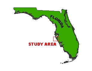
In May of 2006, the U.S. Geological Survey conducted a geophysical survey offshore of Siesta Key, Florida, as part of the USGS Florida Shelf Habitat (FLaSH) Study, a multiagency benthic habitat mapping project. For more information refer to http://coastal.er.usgs.gov/flash/. This report serves as an archive of the processed side scan sonar mosaic, processed singlebeam and swath bathymetry images, processed x,y,z swath bathymetry data, trackline maps, navigation files, GIS files, Field Activity Collection System (FACS) logs, observer's logbook, and formal FGDC metadata. Scanned images of the handwritten FACS logs and handwritten science logbook (12 MB) are also provided as PDF files. Gridded and interpolated surface digital images of the bathymetry are also provided. Refer to the Acronyms page for expansion of acronyms and abbreviations used in this report.
The USGS Florida Integrated Science Center (FISC) - St. Petersburg assigns a unique identifier to each cruise or field activity. For example, 06FSH01 tells us the data were collected in 2006 for the Florida Shelf Habitat (FLaSH) study and the data were collected during the first field activity for that project in that calendar year. Refer to http://walrus.wr.usgs.gov/infobank/programs/html/definition/activity.html for a detailed description of the method used to assign the field activity ID.
Aboard the R/V G.K. Gilbert, side scan sonar and interferometric swath bathymetry data were collected simultaneously along the tracklines. The side scan sonar towfish was towed behind the vessel close to the seafloor. The interferometric swath transducer was pole mounted to the ship's hull. See the digital FACS equipment log (13 KB) for details about the acquisition equipment used. Both raw data sets were stored digitally and processed using CARIS software in the St. Petersburg office. For more detailed information on processing refer to the Equipment and Processing page. Post-processing of the swath data set revealed a motion artifact which is attributed to movement of the pole in relation to the boat. Due to scheduling constraints, the survey was forced to take place in less than ideal weather conditions, which caused a reduction in data quality. The rough seas contributed to both the movement of the pole and the very high noise base seen in the amplitude data.
In addition, singlebeam bathymetry was collected aboard the R/V Streeterville using SANDS, which is a singlebeam acoustic sounding GPS-based hydrographic data collection and processing system. Differential boat position was recorded using GPS referenced to a land-based benchmark which is occupied throughout the survey. Boat position, boat motion (heave, pitch, and roll), and depth readings are collected and stored in real time on the vessel and are later merged with the DGPS information using time correlations. For more detailed information on processing refer to the Equipment and Processing page. CHIRP data were also collected during the survey and are archived separately in Data Series 254 and can be downloaded at https://pubs.usgs.gov/ds/2007/254.
Hansen, M.E., and Peery, G.M., 2004, Protocols and evaluation of sensors for channel characteristic mapping: Technical Report- Prepared for SFWMD Contract C-13105-WO04.
Submetrix training manual, 2000, SEA Advanced Products Ltd.,
To access the information contained on this disc, use a Web browser to open the file index.html. This report is divided into six sections: Navigation Data and Maps, Equipment and Processing, Images, Field Activity Logs, FGDC Metadata, and Software. Links at the top and bottom of each page provide access to these sections. This report contains links to the USGS and collaborators or other resources that are accessible only if access to the Internet is available while viewing these documents.
Funding for this study was provided by the USGS Coastal and Marine Geology Program. We thank R/V G.K. Gilbert captains Dave Bennett and Rich Young of the USGS in St. Petersburg, FL for their assistance in data collection. This document was improved by the reviews of Shawn Dadisman (USGS) and Arnell Harrison (ETI) at the FISC - St. Petersburg, FL.

![]() U.S. Department of the Interior |
U.S. Geological Survey
U.S. Department of the Interior |
U.S. Geological Survey
URL: pubsdata.usgs.gov/pubs/ds/291/index.html
Page Contact Information: Publishing Services
Page Last Modified: Monday, 28-Nov-2016 12:47:38 EST