Data Series 384

LIDAR Illustration

Home Link

Purpose Link

Metadata Link

Collaborators Link

Acronyms Link

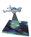
EAARL Coastal Topography–Northern Gulf of Mexico


Collaborators

U.S. Geological Survey

Center for Coastal and Watershed Studies

Integrated Remote Sensing and Modeling Group

National Assessment for Coastal Change Hazards Project


NASA Cooperator Logo and Link

National Aeronautics and Space Administration

Wallops Flight Facility

EAARL: Experimental Advanced Airborne Research Lidar


Accessibility FOIA Privacy Policies and Notices

Take Pride in America home page USA Gov LinkU.S. Department of the Interior | U.S. Geological Survey
URL:pubsdata.usgs.gov/pubs/ds/384/html/collaborators.html
Page Contact Information: Feedback
Page Last Modified: (none)