|
Project Description
These remotely sensed, geographically referenced
elevation measurements of Lidar-derived
coastal topography were produced as a collaborative effort between the
U.S. Geological Survey (USGS),
Florida Integrated Science Center (FISC), St. Petersburg, FL and the National Aeronautics
and Space Administration (NASA),
Wallops Flight Facility, VA. One objective of this research is to
create techniques to survey areas for the purposes of geomorphic change
studies following major storm events. The USGS Coastal and Marine Geology
Program’s National Assessment of Coastal Change Hazards project is a
multi-year undertaking to identify and quantify the vulnerability of
U.S. shorelines to coastal change hazards such as effects of severe
storms, sea-level rise, and shoreline erosion and retreat. Airborne Lidar surveys conducted
during periods of calm weather are compared to surveys collected
following extreme storms in order to quantify the resulting coastal
change. Other applications of high-resolution topography include
habitat mapping, ecological monitoring, volumetric change detection,
and event assessment.
The purpose of this project is to provide highly
detailed and accurate datasets of the northern Gulf of Mexico coastal
areas, acquired on September 19, 2004, immediately following Hurricane
Ivan. The datasets are made available for use as a management tool to
research scientists and natural resource managers. An innovative
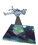
airborne Lidar instrument originally developed at the NASA
Wallops Flight Facility, and known as the Experimental Airborne
Advanced Research Lidar
(EAARL),
was used during data acquisition. The EAARL
system is a raster-scanning, waveform-resolving, green-wavelength (532
nanometer) Lidar
designed to map near-shore bathymetry, topography, and vegetation
structure simultaneously. The EAARL
sensor suite includes the raster-scanning, water-penetrating
full-waveform adaptive Lidar,
a down-looking RGB (red-green-blue) digital camera, a high-resolution
multi-spectral color infrared (CIR) camera, two precision
dual-frequency kinematic carrier-phase GPS receivers and an
integrated miniature digital inertial measurement unit which provide
for sub-meter georeferencing of each laser sample. The nominal EAARL
platform is a twin-engine Cessna 310 aircraft, but the instrument may
be deployed on a range of light aircraft. A single pilot, a Lidar operator, and a data
analyst constitute the crew for most survey operations. This sensor has
the potential to make significant contributions in measuring sub-aerial
and submarine coastal topography within cross-environmental surveys.
Elevation measurements were collected over the survey
area using the EAARL
system on September 19, 2004. The survey resulted in the acquisition of
3.2 gigabytes of data. The data were processed
using the Airborne Lidar Processing System (ALPS), a custom-built
processing system developed in a NASA-USGS collaboration. ALPS supports the
exploration and processing of Lidar
data in an interactive or batch mode. Modules for pre-survey flight
line definition, flight path plotting, Lidar raster and waveform
investigation, and digital camera image playback have been developed.
Processing algorithms have been developed to extract the range to the
first and last significant return within each waveform. ALPS is routinely used
to create maps that represent submerged or sub-aerial topography.
Specialized filtering algorithms have been implemented to determine the
'bare earth' under vegetation from a point cloud of 'last return'
elevations.
Selected Referenes
Nayegandhi, A., Brock, J.C. , and Wright, C.W., in
press, Small-footprint, waveform-resolving Lidar estimation of
submerged and sub-canopy topography in coastal environments.
Brock, J.C., Wright, C.W., Sallenger, A.H., Krabill,
W.B., and Swift, R.N., 2002, Basis and methods of NASA
airborne topographic mapper Lidar
surveys for coastal studies: Journal of Coastal Research, V.
18, no. 1, p. 1–13.
Sallenger, A.H., Wright, C.W., and Lillycrop, J., 2005,
Coastal impacts of the 2004 hurricanes measured with airborne Lidar; initial results: Shore
and Beach, V.73 nos. 2-3, p. 10-14.
Report of the U.S. Geological Survey Lidar workshop sponsored by
the land remote sensing program and held in St.
Petersburg, FL, November 2002 by Michael
Crane, Tonya Clayton, Ellen Raabe, Jason Stoker, Larry Handley, Gerald
Bawden, Karen Morgan, Vivian Queija, OF 2004-1456, U.S. Geological
Survey, 72 pages - Adobe PDF
file.
Resources Inlcuded
DOQQ Naming
convention document
Readme.txt file
|