Habitat--Hueneme Canyon and Vicinity, California

Metadata:

Identification_Information:
Citation:
Citation_Information:
Originator: Charles A. Endris
Originator: H. Gary Greene
Publication_Date: 2012
Title: Habitat--Hueneme Canyon and Vicinity, California
Geospatial_Data_Presentation_Form: vector digital data
Series_Information:
Series_Name: Data Series
Issue_Identification: DS 781
Publication_Information:
Publication_Place: Reston, VA
Publisher: U.S. Geological Survey
Online_Linkage: https://pubs.usgs.gov/ds/781/
Online_Linkage: Online_Linkage: Larger_Work_Citation:
Citation_Information:
Originator: Nadine E. Golden
Publication_Date: 2013
Title: California State Waters Map Series Data Catalog
Geospatial_Data_Presentation_Form: database
Series_Information:
Series_Name: Data Series
Issue_Identification: DS 781
Publication_Information:
Publication_Place: Reston, VA
Publisher: U.S. Geological Survey
Online_Linkage: https://pubs.usgs.gov/ds/781/
Online_Linkage:
Description:
Abstract:
This part of DS 781 presents data for the habitat map of the seafloor of the Hueneme Canyon and Vicinity map area, California. The vector data file is included in "Habitat_HuenemeCanyon.zip," which is accessible from http://pubs.usgs.gov/ds/781/HuenemeCanyon/data_catalog_HuenemeCanyon.html. These data accompany the pamphlet and map sheets of Johnson, S.Y., Dartnell, P., Cochrane, G.R., Golden, N.E., Phillips, E.L., Ritchie, A.C., Kvitek, R.G., Greene, H.G., Krigsman, L.M., Endris, C.A., Clahan, K.B., Sliter, R.W., Wong, F.L., Yoklavich, M.M., and Normark, W.R. (S.Y. Johnson, ed.), 2012, California State Waters Map Series-—Hueneme Canyon and Vicinity, California: U.S. Geological Survey Scientific Investigations Map 3225, 41 p., 12 sheets, scale 1:24,000, https://pubs.usgs.gov/sim/3225/.
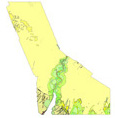
Using multibeam echosounder (MBES) bathymetry and backscatter data, potential marine benthic habitat maps were constructed. The habitats were based on substrate types and documented or "ground truthed" using underwater video images and seafloor samples obtained by the USGS. These maps display various habitat types that range from flat, soft, unconsolidated sediment-covered seafloor to hard, deformed (folded), or highly rugose and differentially eroded bedrock exposures. Rugged, high-relief, rocky outcrops that have been eroded to form ledges and small caves are ideal habitat for rockfish (Sebastes spp.) and other bottom fish such as lingcod (Ophiodon elongatus).
Purpose:
These data are intended for science researchers, students, policy makers, and the general public. These data can be used with geographic information systems or other software.
Supplemental_Information:
References Cited in Entity and Attribute section:
Greene, H.G., Yoklavich, M.M., Starr, R.M., O'Connell, V.M., Wakefield, W.W., Sullivan, D.E., McRea Jr., J.E., and Cailliet, G.M., 1999, A classification scheme for deep seafloor habitats: Oceanologica Acta, v. 22, no. 6, p. 663-678.
Greene, H.G., Bizzarro, J.J., O'Connell, V.M., and Brylinsky, C.K., 2007, Construction of digital potential marine benthic habitat maps using a coded classification scheme and its application, in Todd, B.J., and Greene, H.G., eds., Mapping the Seafloor for Habitat Characterization: Geological Association of Canada, Special Paper 47, p. 141-155.
Any use of trade, product, or firm names is for descriptive purposes only and does not imply endorsement by the U.S. Government.
Although this Federal Geographic Data Committee-compliant metadata file is intended to document the data set in nonproprietary form, as well as in Esri format, this metadata file may include some Esri-specific terminology.
Time_Period_of_Content:
Time_Period_Information:
Single_Date/Time:
Calendar_Date: 2012
Currentness_Reference: Publication Date
Status:
Progress: Complete
Maintenance_and_Update_Frequency: none planned
Spatial_Domain:
Bounding_Coordinates:
West_Bounding_Coordinate: -119.323793
East_Bounding_Coordinate: -119.139726
North_Bounding_Coordinate: 34.222958
South_Bounding_Coordinate: 34.058491
Keywords:
Theme:
Theme_Keyword_Thesaurus: ISO 19115 Topic Category
Theme_Keyword: geoscientificinformation
Theme_Keyword: environment
Theme_Keyword: oceans
Theme_Keyword: imageryBaseMapsEarthCover
Theme:
Theme_Keyword_Thesaurus: Data Categories for Marine Planning
Theme_Keyword: distributions
Theme_Keyword: physical habitats and geomorphology
Theme_Keyword: habitat
Theme:
Theme_Keyword_Thesaurus: Marine Realms Information Bank (MRIB) keywords
Theme_Keyword: seabed
Theme_Keyword: habitats
Theme_Keyword: benthos
Theme:
Theme_Keyword_Thesaurus: USGS Thesaurus
Theme_Keyword: sea-floor characteristics
Theme_Keyword: habitats
Theme_Keyword: benthos
Theme_Keyword: maps and atlases
Theme_Keyword: geospatial datasets
Theme:
Theme_Keyword_Thesaurus: Coastal and Marine Ecological Classification Standard (CMECS)
Theme_Keyword: Marine Nearshore Subtidal
Theme_Keyword: Marine Offshore Subtidal
Theme_Keyword: Transform Continental Margin
Theme_Keyword: Continental/Island Shelf
Theme_Keyword: Rock Substrate
Theme_Keyword: Unconsolidated Mineral Substrate
Place:
Place_Keyword_Thesaurus: Geographic Names Information System (GNIS)
Place_Keyword: Hueneme Canyon
Place_Keyword: Ventura
Place_Keyword: Port of Hueneme
Place_Keyword: Oxnard
Place_Keyword: State of California
Place_Keyword: Pacific Ocean
Place:
Place_Keyword_Thesaurus: Coastal and Marine Ecological Classification Standard (CMECS)
Place_Keyword: Southern California Ecoregion
Stratum:
Stratum_Keyword_Thesaurus: Coastal and Marine Ecological Classification Standard (CMECS)
Stratum_Keyword: Substrate
Access_Constraints: none
Use_Constraints:
USGS-authored or produced data and information are in the public domain from the U.S. Government and are freely redistributable with proper metadata and source attribution. Please recognize and acknowledge the U.S. Geological Survey as the originator(s) of the dataset and in products derived from these data. This information is not intended for navigation purposes.
Point_of_Contact:
Contact_Information:
Contact_Organization_Primary:
Contact_Organization:
U.S. Geological Survey, Pacific Coastal and Marine Science Center
Contact_Person: PCMSC Science Data Coordinator
Contact_Address:
Address_Type: mailing and physical
Address: 2885 Mission Street
City: Santa Cruz
State_or_Province: CA
Postal_Code: 95060-5792
Country: US
Contact_Voice_Telephone: 831-427-4747
Contact_Electronic_Mail_Address: pcmsc_data@usgs.gov
Browse_Graphic:
Browse_Graphic_File_Name: Browse_Graphic_File_Description: image showing geology of Hueneme Canyon and Vicinity
Browse_Graphic_File_Type: JPEG
Native_Data_Set_Environment:
Microsoft Windows Server 2008 R2 Version 6.1 (Build 7601) Service Pack 1; Esri ArcGIS 10.0.0.2414
Cross_Reference:
Citation_Information:
Originator: Samuel Y. Johnson
Originator: Peter Dartnell
Originator: Guy R. Cochrane
Originator: Nadine E. Golden
Originator: Eleyne L. Phillips
Originator: Andrew C. Ritchie
Originator: Rikk G. Kvitek
Originator: H. Gary Greeene
Originator: Lisa M. Krigsman
Originator: Charles A. Endris
Originator: Kevin B. Clahan
Originator: Ray W. Sliter
Originator: Florence L. Wong
Originator: Mary M. Yoklavich
Originator: William R. Normark
Publication_Date: 2012
Title:
California State Waters Map Series--Hueneme Canyon and Vicinity, California
Geospatial_Data_Presentation_Form: pamphlet and map sheets
Series_Information:
Series_Name: Scientific Investigations Map
Issue_Identification: 3225
Publication_Information:
Publication_Place: Reston, VA
Publisher: U.S. Geological Survey
Online_Linkage: http://pubs.usgs.gov/sim/3225/
Data_Quality_Information:
Logical_Consistency_Report:
Map elements were visually checked for overshoots, undershoots, duplicate features, and other errors by the lead authors and by the GIS technician(s) who created the digital database. Review drafts of the map were reviewed internally by at least two other geologists for consistency with basic geologic principles and general conformity to USGS mapping standards.
Completeness_Report:
Contact authors for information about omissions, selection criteria, generalization, definitions used, and other rules used to derive the data set.
Positional_Accuracy:
Horizontal_Positional_Accuracy:
Horizontal_Positional_Accuracy_Report:
Interpretation and polygon delineation of habitats performed at scales from 1:2000 to 1:5000
Lineage:
Source_Information:
Source_Citation:
Citation_Information:
Originator: Peter Dartnell
Originator: Eleyne L. Phillips
Originator: Andrew C. Ritchie
Originator: Rikk G. Kvitek
Originator: Samuel Y. Johnson
Publication_Date: 2012
Title: Bathymetry--Hueneme Canyon and Vicinity, California
Series_Information:
Series_Name: Data Series
Issue_Identification: DS 781
Publication_Information:
Publication_Place: Reston, VA
Publisher: U.S. Geological Survey
Online_Linkage: https://pubs.usgs.gov/ds/781/
Online_Linkage: Online_Linkage:
Type_of_Source_Media: digital file of gridded bathymetry data (ArcInfo GRID)
Source_Time_Period_of_Content:
Time_Period_Information:
Range_of_Dates/Times:
Beginning_Date: 2006
Ending_Date: 2009
Source_Currentness_Reference: ground condition
Source_Citation_Abbreviation: bathy
Source_Contribution: Gridded bathymetry data used for interpretations.
Source_Information:
Source_Citation:
Citation_Information:
Originator: Peter Dartnell
Originator: Eleyne L. Phillips
Originator: Andrew C. Ritchie
Originator: Rikk G. Kvitek
Originator: Samuel Y. Johnson
Publication_Date: 2012
Title: Backscatter A [CSUMB]--Hueneme Canyon and Vicinity, California
Series_Information:
Series_Name: Data Series
Issue_Identification: DS 781
Publication_Information:
Publication_Place: Reston, VA
Publisher: U.S. Geological Survey
Online_Linkage: https://pubs.usgs.gov/ds/781/
Online_Linkage: Online_Linkage:
Type_of_Source_Media: digital file of gridded amplitude data (ArcInfo GRID)
Source_Time_Period_of_Content:
Time_Period_Information:
Range_of_Dates/Times:
Beginning_Date: 2006
Ending_Date: 2007
Source_Currentness_Reference: ground condition
Source_Citation_Abbreviation: backscatterA
Source_Contribution: Gridded backscatter data used for interpretations.
Source_Information:
Source_Citation:
Citation_Information:
Originator: Peter Dartnell
Originator: Eleyne L. Phillips
Originator: Andrew C. Ritchie
Originator: Rikk G. Kvitek
Originator: Samuel Y. Johnson
Publication_Date: 2012
Title: Backscatter B [USGS]--Hueneme Canyon and Vicinity, California
Series_Information:
Series_Name: Data Series
Issue_Identification: DS 781
Publication_Information:
Publication_Place: Reston, VA
Publisher: U.S. Geological Survey
Online_Linkage: https://pubs.usgs.gov/ds/781/
Online_Linkage: Online_Linkage:
Type_of_Source_Media: digital file of gridded amplitude data (ArcInfo GRID)
Source_Time_Period_of_Content:
Time_Period_Information:
Range_of_Dates/Times:
Beginning_Date: 2006
Ending_Date: 2006
Source_Currentness_Reference: ground condition
Source_Citation_Abbreviation: backscatterB
Source_Contribution: Gridded backscatter data used for interpretations.
Source_Information:
Source_Citation:
Citation_Information:
Originator: Peter Dartnell
Originator: James E. Conrad
Originator: Nadine E. Golden
Originator: Eleyne L. Phillips
Originator: Michael E. Boyle
Originator: Brian E. Edwards
Originator: Merit McCrea
Publication_Date: 2013
Title: Video observations from USGS field activity z107sc
Series_Information:
Series_Name: Data Series
Issue_Identification: DS 781
Publication_Information:
Publication_Place: Reston, VA
Publisher: U.S. Geological Survey
Online_Linkage: https://pubs.usgs.gov/ds/781/
Online_Linkage: Online_Linkage:
Type_of_Source_Media: vector digital data
Source_Time_Period_of_Content:
Time_Period_Information:
Range_of_Dates/Times:
Beginning_Date: 20070626
Ending_Date: 20070715
Source_Currentness_Reference: ground condition
Source_Citation_Abbreviation: z107sc
Source_Contribution: underwater video imagery used for interpretations.
Source_Information:
Source_Citation:
Citation_Information:
Originator: Eleyne L. Phillips
Originator: Guy R. Cochrane
Originator: Peter Dartnell
Originator: Nadine E. Golden
Originator: Lisa M. Krigsman
Publication_Date: 2012
Title: Video observations from USGS field activity s1c08sc
Series_Information:
Series_Name: Data Series
Issue_Identification: DS 781
Publication_Information:
Publication_Place: Reston, VA
Publisher: U.S. Geological Survey
Online_Linkage: https://pubs.usgs.gov/ds/781/
Online_Linkage: Online_Linkage:
Type_of_Source_Media: vector digital data
Source_Time_Period_of_Content:
Time_Period_Information:
Range_of_Dates/Times:
Beginning_Date: 20070626
Ending_Date: 20070715
Source_Currentness_Reference: ground condition
Source_Citation_Abbreviation: s1c08sc
Source_Contribution: underwater video imagery used for interpretations.
Source_Information:
Source_Citation:
Citation_Information:
Originator: Eleyne L. Phillips
Originator: Guy R. Cochrane
Publication_Date: 2012
Title: Seafloor character--Hueneme Canyon and Vicinity, California
Series_Information:
Series_Name: Data Series
Issue_Identification: DS 781
Publication_Information:
Publication_Place: Reston, VA
Publisher: U.S. Geological Survey
Online_Linkage: https://pubs.usgs.gov/ds/781/
Online_Linkage: Online_Linkage:
Type_of_Source_Media: GeoTiff
Source_Time_Period_of_Content:
Time_Period_Information:
Range_of_Dates/Times:
Beginning_Date: 2006
Ending_Date: 2007
Source_Currentness_Reference: ground condition
Source_Citation_Abbreviation: sfc
Source_Contribution: seafloor characteristics used for interpretations.
Source_Information:
Source_Citation:
Citation_Information:
Originator: Andrew C. Ritchie
Originator: Samuel Y. Johnson
Originator: Kevin B. Clahan
Publication_Date: 2012
Title:
Geology and geomorphology--Hueneme Canyon and Vicinity, California
Series_Information:
Series_Name: Data Series
Issue_Identification: DS 781
Publication_Information:
Publication_Place: Reston, VA
Publisher: U.S. Geological Survey
Online_Linkage: https://pubs.usgs.gov/ds/781/
Online_Linkage: Online_Linkage:
Type_of_Source_Media: vector digital data
Source_Time_Period_of_Content:
Time_Period_Information:
Single_Date/Time:
Calendar_Date: 2012
Source_Currentness_Reference: Publication Date
Source_Citation_Abbreviation: geology
Source_Contribution: seafloor characteristics used for interpretations.
Process_Step:
Process_Description:
Data used for the creation of the potential marine benthic habitat interpretation consists of multibeam bathymetry, acoustic backscatter, sediment samples, camera-sled imagery, and existing geologic and seafloor interpretive maps. All data were compiled and displayed for interpretation using Esri ArcGIS software, ArcMap v.9.3. The process consists of editing a shapefile within ArcMap, beginning with the construction of polygons to delineate benthic features. A benthic feature is an area with common characteristics which can be characterized as a single potential habitat type. The boundaries and extents of these features were determined from the bathymetric data. In general, interpretations were made at scales between 1:2,000 and 1:5,000. The USGS kindly provided the Center for Habitat Studies with a geodatabase consisting of feature datasets delineating geologic features and attributes for the Santa Barbara Channel. Some of the delineated polygons were preserved as part of the potential marine benthic habitat characterization. However, the Greene and others (2007) code was used in attributing the dataset and additional polygons were added using the methods outlined below. High-resolution multibeam sonar data in the form of bathymetric depth grids (seafloor digital elevation models, referred to as the "bathymetry") were the primary data used in the interpretation of potential habitat types. Shaded-relief imagery ("hillshade") allows for visualization of the terrain and interpretation of submarine landforms. On the basis of these hillshades, areas of rock were identified by their often sharply defined edges and high relative relief; these may be contiguous outcrops, isolated parts of outcrop protruding through sediment cover (pinnacles), or isolated boulders. Although these types of features can be confidently characterized as exposed rock, it is not uncommon to find areas within or around the rocky feature that appear to be covered by a thin veneer of sediment. These areas are identified as "mixed" induration, containing both rock and sediment. Broad areas of the seafloor lacking sharp and angular characteristics are considered to be sediment. Sedimentary features may contain erosional or depositional characteristics recognizable in the bathymetry, such as dynamic bedforms (dunes or sand waves). General morphologic features such as scours, mounds, and depressions were also identified using the hillshade imagery. The combination of acoustic backscatter data and "ground truthed" sediment samples were used to delineate seafloor sediment types within areas identified as "soft (s)" induration. Initially, ground truth data, in the form of grab sample descriptions and average grain size measurements, were categorized into four grain-size categories: mud (m), muddy sand (s/m), sand (s), and sandy gravel (s/g). Backscatter data was then classified into four intensity categories (low, med, high, very high) that are assumed to correspond to relative grain sizes. The aim was to develop an intensity classification of the seafloor that correlated with the data collected from the sediment samples. Thus, the combination of remotely observed data (acoustic backscatter) and directly observed data (sediment grab samples) translates to higher confidence in our ability to interpret broad areas of the seafloor. Nonetheless, we caution against using our sediment type interpretations as anything more than "best-guess" because of the following issues: characterization of contiguous sediment bodies is a difficult procedure because even small areas can exhibit a wide spectrum of backscatter-intensity values that lack distinct boundaries; backscatter intensity can be affected by depth, vegetation, water column conditions, and seafloor relief; and directly observed sediment data, in the form of sediment samples, represents a very small area relative to remotely observed data, requiring broad areas of interpolation. Please refer to Greene and others (2007) for more information regarding the Benthic Marine Potential Habitat Classification Scheme and the codes used to represent various seafloor features.
Source_Used_Citation_Abbreviation: bathy
Source_Used_Citation_Abbreviation: backscatterA
Source_Used_Citation_Abbreviation: backscatterB
Source_Used_Citation_Abbreviation: z107sc
Source_Used_Citation_Abbreviation: s1s08sc
Source_Used_Citation_Abbreviation: sfc
Source_Used_Citation_Abbreviation: geology
Process_Date: 2011
Process_Contact:
Contact_Information:
Contact_Organization_Primary:
Contact_Organization: Center for Habitat Studies, Moss Landing Marine Laboratories
Contact_Person: H. Gary Greene
Contact_Position: Geologist--Principal Investigator
Contact_Address:
Address_Type: physical address
Address: Center for Habitat Studies
City: Moss Landing
State_or_Province: CA
Postal_Code: 95039
Contact_Voice_Telephone: 831-771-4141
Contact_Facsimile_Telephone: 831-663-7264
Contact_Electronic_Mail_Address: greene@mlml.calstate.edu
Process_Step:
Process_Description:
Metadata was modified to bring up to current USGS PCMSC standards. Information for accompanying Scientific Investigations Report added to Abstract and Cross Reference sections. Point of Contact information was updated. USGS Thesaurus and keywords were added, and Process Steps were refined. Details about different Network Resource Name links was given in the Access Instructions section. Phone number for Metadata Contact was corrected. Minor typos were corrected. No data information was changed.
Process_Date: 20180926
Process_Contact:
Contact_Information:
Contact_Person_Primary:
Contact_Person: Susan A Cochran
Contact_Organization:
U.S. Geological Survey, Pacific Coastal and Marine Science Center
Contact_Address:
Address_Type: mailing and physical
Address: 2885 Mission St.
City: Santa Cruz
State_or_Province: CA
Postal_Code: 95060
Country: United States
Contact_Voice_Telephone: 831-460-7545
Contact_Electronic_Mail_Address: scochran@usgs.gov
Spatial_Data_Organization_Information:
Direct_Spatial_Reference_Method: Vector
Point_and_Vector_Object_Information:
SDTS_Terms_Description:
SDTS_Point_and_Vector_Object_Type: GT-polygon composed of chains
Point_and_Vector_Object_Count: 409
Spatial_Reference_Information:
Horizontal_Coordinate_System_Definition:
Planar:
Map_Projection:
Map_Projection_Name: WGS 1984 UTM Zone 11N
Transverse_Mercator:
Scale_Factor_at_Central_Meridian: 0.9996
Longitude_of_Central_Meridian: -117.0
Latitude_of_Projection_Origin: 0.0
False_Easting: 500000.0
False_Northing: 0.0
Planar_Coordinate_Information:
Planar_Coordinate_Encoding_Method: coordinate pair
Coordinate_Representation:
Abscissa_Resolution: 0.000000002220024164500956
Ordinate_Resolution: 0.000000002220024164500956
Planar_Distance_Units: Meter
Geodetic_Model:
Horizontal_Datum_Name: D WGS 1984
Ellipsoid_Name: WGS 1984
Semi-major_Axis: 6378137.0
Denominator_of_Flattening_Ratio: 298.257223563
Entity_and_Attribute_Information:
Detailed_Description:
Entity_Type:
Entity_Type_Label: Habitat_HuenemeCanyon
Entity_Type_Definition: Polygons representing habitat map units
Entity_Type_Definition_Source: This report
Attribute:
Attribute_Label: OBJECTID
Attribute_Definition: Internal feature number.
Attribute_Definition_Source: Esri
Attribute_Domain_Values:
Unrepresentable_Domain:
Sequential unique whole numbers that are automatically generated.
Attribute:
Attribute_Label: Shape
Attribute_Definition: Feature geometry.
Attribute_Definition_Source: Esri
Attribute_Domain_Values:
Unrepresentable_Domain: Coordinates defining the features.
Attribute:
Attribute_Label: Hab_Code
Attribute_Definition: Habitat code
Attribute_Definition_Source: Center for Habitat Studies, Greene and others (1999, 2007)
Attribute_Domain_Values:
Unrepresentable_Domain: Names are in text form, maximum length: 20
Attribute:
Attribute_Label: Hab_Type
Attribute_Definition: Habitat type
Attribute_Definition_Source: Center for Habitat Studies, Greene and others (1999, 2007)
Attribute_Domain_Values:
Unrepresentable_Domain: Names are in text form, maximum length: 50
Attribute:
Attribute_Label: Mega_ID
Attribute_Definition: Megahabitat ID code
Attribute_Definition_Source: Center for Habitat Studies, Greene and others (1999, 2007)
Attribute_Domain_Values:
Unrepresentable_Domain: Names are in text form, maximum length: 10
Attribute:
Attribute_Label: Mega
Attribute_Definition: Megahabitat description
Attribute_Definition_Source: Center for Habitat Studies, Greene and others (1999, 2007)
Attribute_Domain_Values:
Unrepresentable_Domain: Names are in text form, maximum length: 35
Attribute:
Attribute_Label: Ind_ID
Attribute_Definition: Seafloor induration ID code
Attribute_Definition_Source: Center for Habitat Studies, Greene and others (1999, 2007)
Attribute_Domain_Values:
Unrepresentable_Domain: Names are in text form, maximum length: 15
Attribute:
Attribute_Label: Ind
Attribute_Definition: Seafloor induration description
Attribute_Definition_Source: Center for Habitat Studies, Greene and others (1999, 2007)
Attribute_Domain_Values:
Unrepresentable_Domain: Names are in text form, maximum length: 35
Attribute:
Attribute_Label: Sed_ID
Attribute_Definition: Sediment ID code
Attribute_Definition_Source: Center for Habitat Studies, Greene and others (1999, 2007)
Attribute_Domain_Values:
Unrepresentable_Domain: Names are in text form, maximum length: 15
Attribute:
Attribute_Label: Sed
Attribute_Definition: Sediment description
Attribute_Definition_Source: Center for Habitat Studies, Greene and others (1999, 2007)
Attribute_Domain_Values:
Unrepresentable_Domain: Names are in text form, maximum length: 35
Attribute:
Attribute_Label: Mes_Mac_ID
Attribute_Definition: Meso/Macro-habitat ID code
Attribute_Definition_Source: Center for Habitat Studies, Greene and others (1999, 2007)
Attribute_Domain_Values:
Unrepresentable_Domain: Names are in text form, maximum length: 35
Attribute:
Attribute_Label: Mes_Mac
Attribute_Definition: Meso/Macro-habitat description
Attribute_Definition_Source: Center for Habitat Studies, Greene and others (1999, 2007)
Attribute_Domain_Values:
Unrepresentable_Domain: Names are in text form, maximum length: 50
Attribute:
Attribute_Label: Mod_ID
Attribute_Definition: Habitat modifier ID code
Attribute_Definition_Source: Center for Habitat Studies, Greene and others (1999, 2007)
Attribute_Domain_Values:
Unrepresentable_Domain: Names are in text form, maximum length: 35
Attribute:
Attribute_Label: Mod
Attribute_Definition: Habitat modifier description
Attribute_Definition_Source: Center for Habitat Studies, Greene and others (1999, 2007)
Attribute_Domain_Values:
Unrepresentable_Domain: Names are in text form, maximum length: 50
Attribute:
Attribute_Label: Slope_ID
Attribute_Definition: Slope modifier ID code
Attribute_Definition_Source: Center for Habitat Studies, Greene and others (1999, 2007)
Attribute_Domain_Values:
Unrepresentable_Domain: Names are in text form, maximum length: 5
Attribute:
Attribute_Label: Slope
Attribute_Definition: Slope description
Attribute_Definition_Source: Center for Habitat Studies, Greene and others (1999, 2007)
Attribute_Domain_Values:
Unrepresentable_Domain: Names are in text form, maximum length: 35
Attribute:
Attribute_Label: Area_m
Attribute_Definition: Polygon area in meters
Attribute_Definition_Source: Esri Calculate Geometry (Area in square meters) tool
Attribute_Domain_Values:
Range_Domain:
Range_Domain_Minimum: 97.239197
Range_Domain_Maximum: 4185460
Attribute_Units_of_Measure: Float values in square meters
Distribution_Information:
Distributor:
Contact_Information:
Contact_Organization_Primary:
Contact_Organization: U.S. Geological Survey
Contact_Address:
Address_Type: mailing and physical address
Address: 345 Middlefield Rd
City: Menlo Park
State_or_Province: CA
Postal_Code: 94025-3561
Country: USA
Contact_Voice_Telephone: (650) 329-4309
Resource_Description:
The .zip file (Habitat_HuenemeCanyon.zip) includes the .aux, .dbf, .shp, .shx, .sbx, and .sbn files, as well as FGDC-compliant metadata for the habitat data layer of Hueneme Canyon and Vicinity, California.
Distribution_Liability:
Unless otherwise stated, all data, metadata and related materials are considered to satisfy the quality standards relative to the purpose for which the data were collected. Although these data and associated metadata have been reviewed for accuracy and completeness and approved for release by the U.S. Geological Survey (USGS), no warranty expressed or implied is made regarding the display or utility of the data on any other system or for general or scientific purposes, nor shall the act of distribution constitute any such warranty.
Standard_Order_Process:
Digital_Form:
Digital_Transfer_Information:
Format_Name: Shapefile
Format_Version_Number: ArcMap (version 10.0, Esri, 2011)
Format_Specification:
Point, line, and polygon features are in shapefile format and are projected in UTM Zone 11 coordinates.
Format_Information_Content:
The .zip file includes the .aux, .dbf, .shp, .shx, .sbx, and .sbn files, as well as FGDC-compliant metadata for the habitat data layer of Hueneme Canyon and Vicinity, California.
File_Decompression_Technique: WinZip
Transfer_Size: 0.5
Digital_Transfer_Option:
Online_Option:
Computer_Contact_Information: Access_Instructions:
Data can be downloaded using the Network Resource links. The first link will begin a direct download of the data. The second link is a landing page on which all of the downloadable data for a particular region are listed. The third link is a landing page for the entire data catalog.
Fees: none
Technical_Prerequisites:
The downloadable data file has been compressed with the "zip" command and can be unzipped with Winzip (or other tool) on Windows systems. To utilize these data, the user must have software capable of uncompressing the WinZip file and importing and viewing an Esri ArcMap TIFF. Users should download the ArcGIS Project File, HuenemeCanyonGIS.mxd.zip, a compressed (with the "zip" command) version of the ArcMap document (.mxd) that has all the data layers loaded in the table of contents for "Hueneme Canyon and Vicinity" and has all the data symbolized as on the map sheets. Download and save this ArcGIS project file, including all data layers, to the directory the user has created for this GIS.
Metadata_Reference_Information:
Metadata_Date: 20180926
Metadata_Contact:
Contact_Information:
Contact_Organization_Primary:
Contact_Organization:
U.S. Geological Survey, Pacific Coastal and Marine Science Center
Contact_Person: PCMSC Science Data Coordinator
Contact_Address:
Address_Type: mailing and physical
Address: 2885 Mission Street
City: Santa Cruz
State_or_Province: CA
Postal_Code: 95060-5792
Country: US
Contact_Voice_Telephone: 831-427-4747
Contact_Electronic_Mail_Address: pcmsc_data@usgs.gov
Metadata_Standard_Name: Content Standard for Digital Geospatial Metadata
Metadata_Standard_Version: FGDC-STD-001-1998
Metadata_Time_Convention: local time

Generated by mp version 2.9.49 on Wed Sep 26 13:04:38 2018