Slope—Hueneme Canyon and Vicinity, California

Metadata:

Identification_Information:
Citation:
Citation_Information:
Originator: Andrew C. Ritchie
Originator: Samuel Y. Johnson
Originator: Kevin B. Clahan
Publication_Date: 2012
Title: Slope—Hueneme Canyon and Vicinity, California
Geospatial_Data_Presentation_Form: vector digital data
Series_Information:
Series_Name: Data Series
Issue_Identification: DS 781
Publication_Information:
Publication_Place: Reston, VA
Publisher: U.S. Geological Survey
Online_Linkage: https://pubs.usgs.gov/ds/781/
Online_Linkage: Online_Linkage: Larger_Work_Citation:
Citation_Information:
Originator: Nadine E. Golden
Publication_Date: 2013
Title: California State Waters Map Series Data Catalog
Geospatial_Data_Presentation_Form: database
Series_Information:
Series_Name: Data Series
Issue_Identification: DS 781
Publication_Information:
Publication_Place: Reston, VA
Publisher: U.S. Geological Survey
Online_Linkage: https://pubs.usgs.gov/ds/781/
Online_Linkage:
Description:
Abstract:
This part of DS 781 presents data for the curvature map of the Hueneme Canyon and vicinity map area, California. The raster data file is included in "Curvature_HuenemeCanyon.zip," which is accessible from https://pubs.usgs.gov/ds/781/HuenemeCanyon/data_catalog_HuenemeCanyon.html. These data accompany the pamphlet and map sheets of Johnson, S.Y., Dartnell, P., Cochrane, G.R., Golden, N.E., Phillips, E.L., Ritchie, A.C., Kvitek, R.G., Greene, H.G., Krigsman, L.M., Endris, C.A., Clahan, K.B., Sliter, R.W., Wong, F.L., Yoklavich, M.M., and Normark, W.R. (S.Y. Johnson, ed.), 2012, California State Waters Map Series—-Hueneme Canyon and Vicinity, California: U.S. Geological Survey Scientific Investigations Map 3225, 41 p., 12 sheets, scale 1:24,000, https://pubs.usgs.gov/sim/3225/.
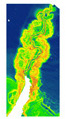
This metadata describes a raster data set of smoothed curvature used as an interpretation aid for mapping geomorphology of Hueneme Canyon. The curvature raster, in conjunction with bathymetry data, amplitude data, and seismic reflection profiles, was used to interpret geology and geomorphology of Hueneme Canyon.
Purpose: Interpretation aid for geologic mapping of Hueneme Canyon
Supplemental_Information:
Any use of trade, product, or firm names is for descriptive purposes only and does not imply endorsement by the U.S. Government.
Although this Federal Geographic Data Committee-compliant metadata file is intended to document the data set in nonproprietary form, as well as in Esri format, this metadata file may include some Esri-specific terminology.
Time_Period_of_Content:
Time_Period_Information:
Range_of_Dates/Times:
Beginning_Date: 2006
Ending_Date: 2007
Currentness_Reference: ground condition
Status:
Progress: Complete
Maintenance_and_Update_Frequency: none planned
Spatial_Domain:
Bounding_Coordinates:
West_Bounding_Coordinate: -119.256515
East_Bounding_Coordinate: -119.207376
North_Bounding_Coordinate: 34.144866
South_Bounding_Coordinate: 34.061607
Keywords:
Theme:
Theme_Keyword_Thesaurus: Global Change Master Directory (GCMD)
Theme_Keyword: Seafloor Topography
Theme:
Theme_Keyword_Thesaurus: Data Categories for Marine Planning
Theme_Keyword: Bathymetry and Elevation
Theme:
Theme_Keyword_Thesaurus: Marine Realms Information Bank (MRIB) keywords
Theme_Keyword: seabed
Theme_Keyword: multibeam echo sounder
Theme_Keyword: sidescan sonar
Theme:
Theme_Keyword_Thesaurus: USGS Thesaurus
Theme_Keyword: sonar methods
Theme_Keyword: image mosaics
Theme_Keyword: marine geophysics
Theme_Keyword: lidar
Theme_Keyword: maps and atlases
Theme_Keyword: geospatial datasets
Theme:
Theme_Keyword_Thesaurus: None
Theme_Keyword: U.S. Geological Survey
Theme_Keyword: USGS
Theme_Keyword: Coastal and Marine Geology Program
Theme_Keyword: CMGP
Theme_Keyword: Pacific Coastal and Marine Science Center
Theme_Keyword: PCMSC
Theme:
Theme_Keyword_Thesaurus: Coastal and Marine Ecological Classification Standard (CMECS)
Theme_Keyword: Marine Nearshore Subtidal
Theme_Keyword: Marine Offshore Subtidal
Theme_Keyword: Transform Continental Margin
Theme_Keyword: Continental/Island Shelf
Theme:
Theme_Keyword_Thesaurus: ISO 19115 Topic Category
Theme_Keyword: geoscientificinformation
Theme_Keyword: imageryBaseMapsEarthCover
Theme_Keyword: oceans
Place:
Place_Keyword_Thesaurus: Geographic Names Information System (GNIS)
Place_Keyword: Hueneme Canyon
Place_Keyword: Ventura
Place_Keyword: Port of Hueneme
Place_Keyword: Oxnard
Place_Keyword: State of California
Place_Keyword: Pacific Ocean
Place:
Place_Keyword_Thesaurus: Coastal and Marine Ecological Classification Standard (CMECS)
Place_Keyword: Southern California Ecoregion
Access_Constraints: none
Use_Constraints:
USGS-authored or produced data and information are in the public domain from the U.S. Government and are freely redistributable with proper metadata and source attribution. Please recognize and acknowledge the U.S. Geological Survey as the originator(s) of the dataset and in products derived from these data. This information is not intended for navigation purposes.
Point_of_Contact:
Contact_Information:
Contact_Organization_Primary:
Contact_Organization:
U.S. Geological Survey, Pacific Coastal and Marine Science Center
Contact_Person: PCMSC Science Data Coordinator
Contact_Address:
Address_Type: mailing and physical
Address: 2885 Mission Street
City: Santa Cruz
State_or_Province: CA
Postal_Code: 95060-5792
Country: US
Contact_Voice_Telephone: 831-427-4747
Contact_Electronic_Mail_Address: pcmsc_data@usgs.gov
Browse_Graphic:
Browse_Graphic_File_Name: Browse_Graphic_File_Description: Image showing curvature data of Hueneme Canyon and Vicinity
Browse_Graphic_File_Type: JPEG
Native_Data_Set_Environment:
Microsoft Windows Server 2008 R2 Version 6.1 (Build 7601) Service Pack 1; ESRI ArcGIS 10.0.0.2414
Cross_Reference:
Citation_Information:
Originator: Samuel Y. Johnson
Originator: Peter Dartnell
Originator: Guy R. Cochrane
Originator: Nadine E. Golden
Originator: Eleyne L. Phillips
Originator: Andrew C. Ritchie
Originator: Rikk G. Kvitek
Originator: H. Gary Greeene
Originator: Lisa M. Krigsman
Originator: Charles A. Endris
Originator: Kevin B. Clahan
Originator: Ray W. Sliter
Originator: Florence L. Wong
Originator: Mary M. Yoklavich
Originator: William R. Normark
Publication_Date: 2012
Title:
California State Waters Map Series--Hueneme Canyon and Vicinity, California
Geospatial_Data_Presentation_Form: pamphlet and map sheets
Series_Information:
Series_Name: Scientific Investigations Map
Issue_Identification: 3225
Publication_Information:
Publication_Place: Reston, VA
Publisher: U.S. Geological Survey
Online_Linkage: http://pubs.usgs.gov/sim/3225/
Data_Quality_Information:
Logical_Consistency_Report:
Slope units were checked for validity by comparing slope values with elevation profiles.
Completeness_Report: Data are complete for the map area indicated
Positional_Accuracy:
Horizontal_Positional_Accuracy:
Horizontal_Positional_Accuracy_Report:
Bathymetric sonar and LiDAR data have a horizontal accuracy greater than the resolution of the base data. the smoothing algorithm applied to the data reduces the precision of the slope calculation by averaging values over a 4-cell radius, but does not decrease horizontal accuracy.
Lineage:
Source_Information:
Source_Citation:
Citation_Information:
Originator: Peter Dartnell
Originator: Eleyne L. Phillips
Originator: Andrew C. Ritchie
Originator: Rikk G. Kvitek
Originator: Samuel Y. Johnson
Publication_Date: 2012
Title: Bathymetry--Hueneme Canyon and Vicinity, California
Series_Information:
Series_Name: Data Series
Issue_Identification: DS 781
Publication_Information:
Publication_Place: Reston, VA
Publisher: U.S. Geological Survey
Online_Linkage: https://pubs.usgs.gov/ds/781/
Online_Linkage: Online_Linkage:
Type_of_Source_Media: digital file of gridded bathymetry data (ArcInfo GRID)
Source_Time_Period_of_Content:
Time_Period_Information:
Range_of_Dates/Times:
Beginning_Date: 2006
Ending_Date: 2009
Source_Currentness_Reference: ground condition
Source_Citation_Abbreviation: bathy
Source_Contribution: Gridded bathymetry data (2-meter resolution).
Process_Step:
Process_Description:
Source elevation data were combined into a single elevation raster and smoothed using a FocalMean algorithm in ArcGIS 9.3.1, as follows:
focalmean([elevation_source], circle, 4, data)
This operation smoothes the data by calculating the mean of all cells for which the cell center is within a 4-cell radius of the target cell - essentially calculating a rolling mean of elevation over the entire grid.
Source_Used_Citation_Abbreviation: bathy
Process_Date: 2010
Source_Produced_Citation_Abbreviation: smooth_bathy
Process_Step:
Process_Description:
The slope, in degrees, of the smoothed source elevation data was calculated using the 3D-analyst slope function in ArcGIS 9.3.1. This function calculates the maximum rate of change in a plane fitted through a 3x3 neighborhood around the target cell. The rate of change is calculated using the average maximum technique of Burrough and McDonnell (1998).
Reference cited: Burrough, P.A. and McDonnell, R.A., 1998, Principles of Geographical Information Systems: New York, Oxford University Press, p. 190.
Source_Used_Citation_Abbreviation: smooth_bathy
Process_Date: 2010
Process_Step:
Process_Description:
Metadata was modified to bring up to current USGS PCMSC standards. Information for accompanying Scientific Investigations Report added to Abstract and Cross Reference sections. Point of Contact information was updated. USGS Thesaurus and keywords were added, and Process Steps were refined. Details about different Network Resource Name links was given in the Access Instructions section. Phone number for Metadata Contact was corrected. Minor typos were corrected. No data information was changed.
Process_Date: 20180926
Process_Contact:
Contact_Information:
Contact_Person_Primary:
Contact_Person: Susan A Cochran
Contact_Organization:
U.S. Geological Survey, Pacific Coastal and Marine Science Center
Contact_Address:
Address_Type: mailing and physical
Address: 2885 Mission St.
City: Santa Cruz
State_or_Province: CA
Postal_Code: 95060
Country: United States
Contact_Voice_Telephone: 831-460-7545
Contact_Electronic_Mail_Address: scochran@usgs.gov
Spatial_Data_Organization_Information:
Direct_Spatial_Reference_Method: Raster
Raster_Object_Information:
Raster_Object_Type: Pixel
Row_Count: 4572
Column_Count: 2168
Spatial_Reference_Information:
Horizontal_Coordinate_System_Definition:
Planar:
Map_Projection:
Map_Projection_Name: WGS 1984 UTM Zone 11N
Transverse_Mercator:
Scale_Factor_at_Central_Meridian: 0.9996
Longitude_of_Central_Meridian: -117.0
Latitude_of_Projection_Origin: 0.0
False_Easting: 500000.0
False_Northing: 0.0
Planar_Coordinate_Information:
Planar_Coordinate_Encoding_Method: coordinate pair
Coordinate_Representation:
Abscissa_Resolution: 0.000000002220024164500956
Ordinate_Resolution: 0.000000002220024164500956
Planar_Distance_Units: Meter
Geodetic_Model:
Horizontal_Datum_Name: D WGS 1984
Ellipsoid_Name: WGS 1984
Semi-major_Axis: 6378137.0
Denominator_of_Flattening_Ratio: 298.257223563
Entity_and_Attribute_Information:
Detailed_Description:
Entity_Type:
Entity_Type_Label: value
Entity_Type_Definition:
cell values are slope in degrees. represented as 32 bit float in the GEOTIFF standard format. A worldfile (TFW) is provided as well.
Entity_Type_Definition_Source: USGS
Distribution_Information:
Distributor:
Contact_Information:
Contact_Organization_Primary:
Contact_Organization: U.S. Geological Survey
Contact_Address:
Address_Type: mailing and physical address
Address: 345 Middlefield Rd
City: Menlo Park
State_or_Province: CA
Postal_Code: 94025-3561
Country: USA
Contact_Voice_Telephone: (650) 329-4309
Resource_Description:
The .zip file (Slope_HuenemeCanyon.zip) includes the .tfw, .tif, .tif.aux.xml, and .tif.ovr, files, as well as FGDC-compliant metadata for the Slope data layer in the Hueneme Canyon and Vicinity region of California.
Distribution_Liability:
Unless otherwise stated, all data, metadata and related materials are considered to satisfy the quality standards relative to the purpose for which the data were collected. Although these data and associated metadata have been reviewed for accuracy and completeness and approved for release by the U.S. Geological Survey (USGS), no warranty expressed or implied is made regarding the display or utility of the data on any other system or for general or scientific purposes, nor shall the act of distribution constitute any such warranty.
Standard_Order_Process:
Digital_Form:
Digital_Transfer_Information:
Format_Name: GeoTiff
Format_Version_Number: ArcMap (version 10.0, ESRI, 2011)
Format_Specification:
Raster data layer is registered TIFF image in the UTM Zone 11 coordinate system.
Format_Information_Content:
The .zip file for the TIFF image includes the image (.tif), the world registration file (.tfw), and FGDC-compliant metadata.
File_Decompression_Technique: WinZip
Transfer_Size: 46
Digital_Transfer_Option:
Online_Option:
Computer_Contact_Information: Access_Instructions:
Data can be downloaded using the Network Resource links. The first link will begin a direct download of the data. The second link is a landing page on which all of the downloadable data for a particular region are listed. The third link is a landing page for the entire data catalog.
Fees: none
Technical_Prerequisites:
The downloadable data file has been compressed with the "zip" command and can be unzipped with Winzip (or other tool) on Windows systems. To utilize these data, the user must have software capable of uncompressing the WinZip file and importing and viewing an Esri ArcMap TIFF. Users should download the ArcGIS Project File, HuenemeCanyonGIS.mxd.zip, a compressed (with the "zip" command) version of the ArcMap document (.mxd) that has all the data layers loaded in the table of contents for "Hueneme Canyon and Vicinity" and has all the data symbolized as on the map sheets. Download and save this ArcGIS project file, including all data layers, to the directory the user has created for this GIS.
Metadata_Reference_Information:
Metadata_Date: 20180926
Metadata_Contact:
Contact_Information:
Contact_Organization_Primary:
Contact_Organization:
U.S. Geological Survey, Pacific Coastal and Marine Science Center
Contact_Person: PCMSC Science Data Coordinator
Contact_Address:
Address_Type: mailing and physical
Address: 2885 Mission Street
City: Santa Cruz
State_or_Province: CA
Postal_Code: 95060-5792
Country: US
Contact_Voice_Telephone: 831-427-4747
Contact_Electronic_Mail_Address: pcmsc_data@usgs.gov
Metadata_Standard_Name: Content Standard for Digital Geospatial Metadata
Metadata_Standard_Version: FGDC-STD-001-1998

Generated by mp version 2.9.49 on Wed Sep 26 13:52:20 2018