

Data Files from the Grays Harbor Sediment Transport Experiment Spring 2001
 |
 |
|
| Data Series 98 in PDF Format | Clickable Site Map | Data Files on DVD |
The data contained on these DVDs are from the Grays Harbor Sediment Transport Experiment Spring 2001, part of the Southwest Washington Coastal Erosion Study (SWCES). The SWCES is a multiyear multidisciplinary investigation of the coastal region between Tillamook Head, Oregon and Point Grenville, Washington cosponsored by the U. S. Geological Survey and the Washington State Department of Ecology.
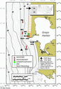
The Grays Harbor Sediment Transport Experiment was a series of measurements made with instruments deployed near the entrance to Grays Harbor, Washington, between May 4 and July 11, 2001. Collection of coastal processes data was combined with weekly topographic and monthly bathymetric surveys of the area. The objective of the spring 2001 experiment was to measure wave conditions during the time when the beaches typically rebuild, and to collect comprehensive sediment-transport measurements. The measurements will be used (1) to infer circulation and sediment-transport patterns on the northern flank of the ebb-tidal delta, (2) to develop and validate wave, current, and suspended-sediment transport models near the entrance to Grays Harbor, and (3) provide boundary conditions for littoral transport calculations. Site locations and deployment times are listed here, and a complete description of the experiment is provided in Data Series 98, included in Adobe PDF format.
Data are from various types of instruments: SonTek Inc. acoustic doppler profilers (ADPs), a SonTek Inc. pulse-coherent acoustic Doppler profiler (PCADP), SonTek Inc. acoustic Doppler Ocean and Field velocimeters (ADVOs and ADVFs), an Aquatec Group acoustic backscatter sensor (ABS), and Imagenex Technology Corp. fan and profiling sonars. (Any use of trade, firm, or product names is for descriptive purposes only and does not imply endorsement by the U.S. Government). Various sensors were deployed with each instrument; for more information, refer to the Data Series Report.
The data have been converted to engineering units using software provided by the instrument manufacturers (with the exception of the PCADP), but no quality assurance checks have been performed. The resulting plain-text (ASCII) files have been compressed and archived in the .zip format, which can be read by software available for Unix, Windows, and Macintosh operating systems. Directory listings for the .zip files are included as plain-text files.
Data are contained on two DVDs, as indicated in the following table. You can navigate to specific files using the data file table, or by using the interactive map.
Location of Data Files on Compact Disks
(see map or table for location of sites)| Disk | Contents |
|---|---|
| DVD 01 |
|
| DVD 02 |
|
The Grays Harbor Sediment Transport Experiment Spring 2001 was preceded by the Grays Harbor Wave Refraction Experiment in Winter 1999. Data collection from this experiment is detailed in U.S. Geological Survey Open-File Report 00-404, entitled Grays Harbor Wave Refraction Experiment 1999: Data Report by Guy Gelfenbaum, Christopher R. Sherwood, Laura A. Kerr, and Keith Kurrus and can be found at https://pubs.usgs.gov/of/2000/of00-404/). More information about the Southwest Washington Coastal Erosion Study can be found at http://www.ecy.wa.gov/programs/sea/swces/index.htm.
Note regarding binary files: Raw binary files (.adp files) for the acoustic doppler profiler (ADP) and pulse-coherent acoustic doppler profiler (PCADP) data have been included on DVD02. These files can only be read using custom software, such as SonTek's ViewADP program. Raw binary files (.adr files) for the acoustic Doppler ocean and field velocimeter data have also been included on DVD02. These files can only be read using custom software, such as SonTek's software gadvhdr and related programs. Accompanying plain-text pressure-sensor calibration files (.drk files) are required to process pressure data from the ADP, PCADP, and ADVF. Raw binary files (.aqa and .aqf) for the acoustic backscatter sensor data have been included in a .zip format on DVD01. These data can be read using custom software such as Aquatec's AquaView program or by loading the data into Matlab using the m-file contained on DVD01, LoadABS.m (see note). (See the text of the m-file for more information.)
Note regarding sonar movie files: Images collected by the Imagenex Technology Corp. fan and profiling sonar are provided with the report as .avi movie files, which can be viewed with a video viewer such as Windows Media Player.
For additional information, contact:
Christopher R. Sherwood
(csherwood@usgs.gov (508) 457 2269)
Coastal and Marine Geology
384 Woods Hole Road
Woods Hole, MA 02543-1598
or
Guy Gelfenbaum
(ggelfenbaum@usgs.gov (650) 329 5483)
Coastal and Marine Geology, MS-999
345 Middlefield Road
Menlo Park, CA 94025
U.S. Department of the Interior, U.S. Geological Survey
URL: https://pubs.usgs.gov/ds/98/DVD-1/index.htm
Contact: csherwood@usgs.gov
Last modified: December 5, 2005 (mfd)