Data Series 411
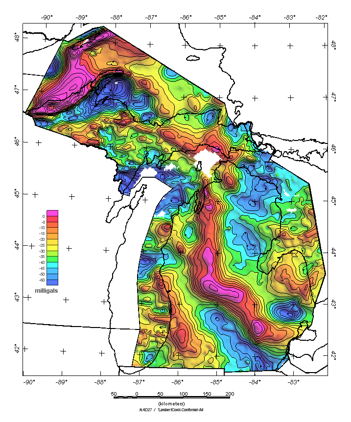
| Previous gravity maps of
Michigan and the Great Lakes were published by Klasner and others
(1979) and O'Hara (1981). The complete Bouguer gravity anomaly grid
used to make the contour map below was compiled from 33 different
gravity surveys that total 20,412 gravity measurements. Surveys
with fewer than 5 stations within Michigan were discarded. Bouguer
anomaly values were interpolated into a grid with 2,500 meter interval.
Table 2 lists the surveys giving the National Geospatial and Imaging Agency (NGA)
survey code, and the number of stations within Michigan used from each
survey. Land gravity data came from the University of Texas-El Paso (UTEP) / PACES research center
database.
The three Great Lakes surveys (#3235 Lake Superior, #3974 Lake Michigan, and #3738 Lake Huron)
are listed separately at the end of
Table 2.
These three surveys were
obtained from the
National Geophysical Data Center (NGDC) CD-ROM
(Dater and others, 1999). Observed gravity measurements relative to the International Gravity Standardization Net 1971 (IGSN-71 datum (Morelli, 1974; Defense Mapping Agency, 1974) were reduced to the complete Bouguer anomaly using the 1967 gravity formula (International Union of Geodesy and Geophysics, 1971) and a reduction density of 2.67 grams per cubic centimeter. Data were collected in Lake Superior and the southern part of Lake Michigan using LaCoste-Romberg geodetic underwater gravity meters on the lake bottom by Wold and Berkson (1977), whereas data were collected in Lake Huron and the northern part of Lake Michigan with ship gravimeters at the lake surface (O'Hara, 1981). Terrain corrections were made only for the land measurements and were calculated radially outward from each station to a distance of 167 kilometers, using a method developed by Plouff (1977). Accuracy of the lake survey data is less than the land survey data. Map below shows the Michigan complete Bouguer gravity anomaly
Gravity Grid Projection Specifications
|
Revised March 7, 2018
Posted March 2009 |
For more information about this report contact: Steve Snyder.

![]() U.S. Department of the Interior |
U.S. Geological Survey
U.S. Department of the Interior |
U.S. Geological Survey
URL: http://pubsdata.usgs.gov/pubs/ds/ds411/mi_boug.htm
Page Contact Information: GS Pubs Web Contact
Page Last Modified: Wednesday, 07-Mar-2018 13:15:43 EST