![]()
| To PREVIOUS Page To Contents | To Title Page To NEXT Page |
| Surface
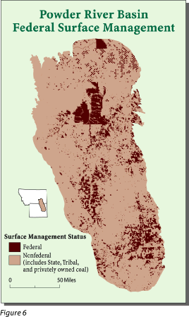
ownership can differ from mineral ownership for the same area. Figure 6
shows the Powder River Basin, Wyoming and Montana, which has the largest
in-place coal resources of any coal field in the contiguous U.S. (Keystone,
1997) and produces over one-fourth of the Nation's total coal (The Mining
Record, 1997). Most of the surface of the basin is privately
owned, yet almost all of the coal is Federally owned. This separation of
jurisdiction may become a legal issue that results in Federally owned coal
resources not being developed. Our digital database identifies areas where
surface ownership differs from mineral ownership. |
|
|
|
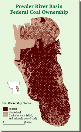 |
| See "Federal surface management in the Powder River Basin"- Appendix 2, Figure 5 in Open-File Report 98-102, Land Status and Federal Mineral Ownership in the Powder River Basin, Wyoming and Montana: a Digital Data Set for Geographic Information Systems. | See "Federal coal ownership (includes other Federal minerals)" - Appendix 2, Figure 6 in Open-File Report 98-102, Land Status and Federal Mineral Ownership in the Powder River Basin, Wyoming and Montana: a Digital Data Set for Geographic Information Systems, |
| To PREVIOUS Page To Contents | To Title Page To NEXT Page |
| U. S.
Department of the Interior U. S. Geological Survey |
USGS
Fact Sheet FS-012-98 February 1998 |