|
The U.S. Geological
Survey shaking-hazard maps for the United States are based on current information
about the rate at which earthquakes occur in different areas and on how
far strong shaking extends from earthquake sources.
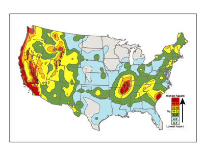
Colors on this particular map show the levels of horizontal shaking that
have a 1-in-50 chance of being exceeded in a 50-year period.
Shaking is expressed as a percentage of g (g is the acceleration of a falling
object due to gravity). |
| Estimating earthquake
hazards |
|
Earthquake hazard refers to the consequences of an earthquake that may disrupt
the normal activities of people or cause them loss. Most hazard
arises from ground shaking caused by waves that emanate from the
abrupt fault movement during an earthquake. Seismic hazard maps
depict the ground shaking that is expected to be exceeded at a selected
probability (or chance) over a specific time period. Estimates of
this probabilistic ground shaking, or hazard, at any given location
must account for many factors including the possible shaking from
all likely earthquakes and the types of rocks and soil in the region. |
 |
|
The USGS produces earthquake (seismic) hazard maps on a national
scale. Hazard maps are also now produced in select urban areas.
At either scale there are a suite of maps for different probabilities
and time periods; the choice of which to use depends upon the needs
of the user. Builders of a dam, for instance, might want to consider
longer periods of time and lower likelihood that shaking will be
exceeded than a home builder. This is because a dam is built to
have a longer life, and damage to it would have a greater impact
on society. The bridge designer would thus use a hazard map with,
say, a 2-percent chance of a given level of shaking being exceeded
in 50 years, while a home builder is more likely to use a map with
a 10-percent chance of being exceeded in 50 years. |
|
| Earthquake hazards in the Central United States |
One of the most prominent features on the national seismic hazard maps is a zone of high hazard surrounding the New
Madrid region in the Central United States. The hazard in this region is as high as for places in California, despite a
lower level of modern-day earthquake activity. Scientists have designated this as a high hazard region based on studies of
buried sand blow deposits within the Mississippi River Valley. Sand blow deposits are believed to be the byproduct
of strong ground shaking associated with large earthquakes (see box Digging up the past). These deposits have been dated at about A.D.
900 and A.D. 1450 and suggest that major earthquakes (magnitude 7 or greater) reoccur in the region approximately every
500 years, with the last sequence being in 1811-1812.
A five hundred-year interval between magnitude 7 or greaterearthquakes is much more frequent than expected, given the current level of earthquake
activity in the New Madrid region. Elsewhere scientists use the frequency of small and moderate earthquakes to estimate the likelihood of larger events, but
in the New Madrid region, this rule of thumb does not appear to apply. As anyone who lives in the New Madrid region would testify, earthquakes are felt in the
New Madrid region much less frequently than in California, despite the similar |
|