
|
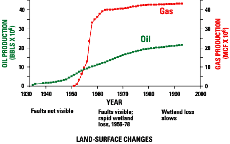
| Figure 3. Cumulative hydrocarbon production in the Port Neches Field, Tex., from 1930 to 1994, compared with changes in faults and wetlands observed in air photographs. From White and Morton (1997). Wetlands began rapidly disappearing when the field began rapidly producing large volumes of gas in the early 1950's. Wetland loss slowed after 1978, when hydrocarbon production rates declined rapidly. Oil production is in millions of barrels; gas production is in billions of cubic feet (to convert to cubic meters, multiply cubic feet by 0.02832). |
 |