| |  | | | | Subsidence & Hydrocarbon Production |  |
| | | | | | | | | | |
|  |
| | |
| | Subsidence and Hydrocarbon Production In the Gulf Coast region, subsidence was first linked to hydrocarbon production in the mid-1920's at the Goose Creek Field near Galveston, Tex. (Pratt and Johnson, 1926). Subsidence at Goose Creek of about 1 meter (m) was enough to change the setting from a vegetated upland to open water. 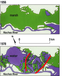 |  |  | | Figure 2. Air photograph of the Port Neches oil and gas field in Texas in 1978 and maps showing that wetlands above the field were healthy and continuous in 1956 but deteriorated and were converted to open water by 1978. The change was caused by induced subsidence and fault reactivation resulting from hydrocarbon production. From White and Morton (1997). Relative motion along faults: D, down; U, up. [larger version] | A similar pattern of production-induced subsidence, which led to wetland replacement by open water, occurred at the Port Neches Field, Tex., between 1956 and 1978 (figs. 2 and 3). The similarity in area of wetland loss in 1978 compared with present conditions suggests that the subsidence was rapid initially but then slowed or possibly stopped. 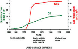 | Figure 3. Cumulative hydrocarbon production in the Port Neches Field, Tex., from 1930 to 1994, compared with changes in faults and wetlands observed in air photographs. From White and Morton (1997). Wetlands began rapidly disappearing when the field began rapidly producing large volumes of gas in the early 1950's. Wetland loss slowed after 1978, when hydrocarbon production rates declined rapidly. Oil production is in millions of barrels; gas production is in billions of cubic feet (to convert to cubic meters, multiply cubic feet by 0.02832). [larger version] | Induced subsidence cannot be sustained indefinitely. Instead, the duration of surface adjustment is related to the history of production. As shown in figure 3, there was a time gap between the onset of production and the first visible evidence of surface disturbance and wetland loss. Whatever losses are occurring today, they are occurring at a much slower rate than when the wetlands deteriorated between 1956 and 1978. This reduction in rates of subsidence corresponds to the rapid decline in hydrocarbon production. « Introduction | Regional Depressurization » |