| Back | |||||||||||||||||||||||||||||||
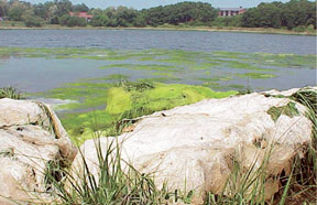
Changes in Ground-Water Flow and their Effects on Water ResourcesChanges on Lower Cape Cod that may affect ground-water quality and flow in the aquifer system include (1) increased land development and population growth, which could affect the quality and quantity of ground water for both drinking water and for the maintenance of freshwater and coastal ecosystems, (2) estuarine habitat restoration through the removal of tide-control structures and possible alterations to ground-water quality as a result of restoring natural tidal fluctuations, and (3) sea-level rise and its effect on water levels, streamflows, and the depth to the freshwater/saltwater interface. Land Development and Ground-Water QualityThe primary concerns related to increased land development are the increase in nonpoint-source contamination to the aquifer from septic systems and lawn fertilizers, and point-source loading from gasoline stations and municipal landfills (Godfrey and others, 1999). Increased loading of nutrients, such as nitrogen and phosphorus, to the aquifer is of particular concern because of the potential for increased eutrophication of fresh and coastal surface-water bodies. Eutrophication is the process by which continued nutrient loading to surface-waters bodies stimulates excessive plant and algae growth; the resulting accumulation of organic matter can lead to the depletion of dissolved oxygen and to fish kills. In coastal waters, nutrient enrichment has caused nuisance algal blooms (fig. 9) and the loss of eelgrass beds, an important submerged aquatic habitat for shellfish and finfish (Short and Burdick, 1996).
Depending on the source of recharged water, many toxic constituents may flow with ground water and affect aquatic ecosystems. On Lower Cape Cod, domestic wastewater, which includes many compounds intended for household or medicinal use, is generally disposed of through onsite septic systems. These contaminants may affect both ground-water supplies and downgradient surface-water ecosystems (John Colman, U.S. Geological Survey, written commun., 2003), with potential chronic or acute effects to both individual species and entire ecosystems. Land Development and Ground-Water FlowPresently (2004), only Provincetown and portions of Truro are serviced by a large capacity, municipal water-supply system that withdraws water from the Pamet flow lens. Other portions of Lower Cape Cod obtain drinking water from shallow, private wells. As land development increases and wastewater continues to be returned to the aquifer through onsite septic systems, there is a growing concern that increased amounts of nonpoint-source contamination in the aquifer system may degrade the water supply. If the water supply is adversely affected, it may necessitate a shift from small-capacity, private wells to larger, more centralized municipal systems that can be managed more efficiently than the current water supply (Sobczak and Cambareri, 2002). Federal, State, and local officials responsible for managing and protecting water resources are concerned that such a shift may cause ecologically detrimental declines in the water table and in pond levels, and cause decreased ground-water discharge to streams and coastal areas, and increased risk of saltwater intrusion.
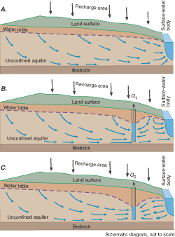
A pumping well can alter ground-water discharge to downgradient surface-water bodies by capturing water that would discharge to these bodies (figs. 10A, B); and if the pumping rate is great enough, by reversing the flow direction so that the surface-water bodies contribute water directly to the pumping well (fig. 10C). This pumping can cause declines in pond levels, increases in the depth to the water table beneath inland wetlands, reductions in streamflow, and reductions in ground-water discharge to the coast. These changes can reduce the water available to shoreline plants, decrease the flooding depth and duration of vernal pools, impede migratory fish passage, and alter the salinity of estuaries, all of which alter a diverse biotic community.
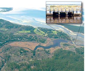
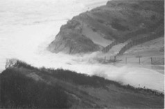
Salt-Marsh Diking and Tidal RestorationOngoing efforts to restore tidal flow to Lower Cape Cod coastal marshes, restricted for the past 150 years for mosquito control, marsh drainage, and flood control, may affect the ground-water-flow system. Tide-control structures (fig. 12) were built at the Herring River in Wellfleet, the Pamet River and East Harbor (Pilgrim Lake) in Truro, and Hatches Harbor in Provincetown. These structures restrict tidal flow, reduce high-tide heights, impede low-tide drainage, and thereby degrade nearly 2,500 acres of original salt-marsh estuaries on Lower Cape Cod (fig. 1) (Roman and others, 1995). As a result, NPS and other Federal, State, and local resource managers are assessing the potential hydrologic and ecological effects of removing tide-control structures and monitoring the results of ongoing restoration at Hatches and East Harbors to determine whether these marshes are returning to their natural state.
Effects on Estuarine HabitatsWith the installation of large culverts in the Hatches Harbor tide-control structure (Provincetown, MA) in 1998, tidal range has been mostly restored after 68 years of diking. Seawater is again flooding the wetlands during high tides, causing the decline of exotic and invasive plants, especially common reed (Phragmites), and the recolonization of the marsh by native salt-marsh plants and animals. In addition, better low-tide drainage and tidal flushing have naturally controlled mosquitoes (Portnoy and others, 2003). With partial tidal restoration at East Harbor (Pilgrim Lake, fig. 1) in 2002, nuisance midges and introduced carp have been replaced by a rich assemblage of native estuarine finfish, shellfish, and submerged aquatic vegetation, such as widgeon grass and eelgrass. This system, diked since 1868, had chronic eutrophication, summertime oxygen depletions, and nuisance insect problems for decades prior to the 2002 partial opening. The largest diked estuary on the Lower Cape is the Herring River (Wellfleet, MA). Restoration of this estuary, tide-restricted since 1909, is expected to eliminate water-quality problems, and also to restore up to 1,100 acres of native salt-marsh estuary (Roman and others, 1995). Presently, much of this marsh is constantly drained, leading to the leaching of acid sulfates and metals, which in turn stresses fish and other aquatic animals, and favors nuisance mosquitoes. Drainage has also allowed trees and shrubs to replace original salt-marsh plants, and has caused the original water-logged peat to shrink and subside. Wetland subsidence combined with sea-level rise may prohibit long-term wetland survival. Hydrologic and ecological research has shown that restored tidal flow can reverse these trends and restore native habitats (Portnoy, 1999; Spaulding and Grilli, 2001; Portnoy and others, 2003). Finally, tidal restoration of the upper Pamet River (fig. 1) marshes, diked since about 1869, has been considered, particularly after a 1991 breach of the barrier beach separating the Pamet River from the Atlantic Ocean (Portnoy, 2001). Effects on Ground-Water ResourcesProposed tide restorations to the upper Pamet River and Herring River (fig. 1) have raised concerns about the potential effects on nearby residents from projected increases in tidal exchange. Specifically, restored tidal flow could increase ground-water levels, compromising onsite septic systems, or disturb the freshwater/saltwater interface, affecting domestic wells in the adjacent developed uplands. The Cape Cod Commission, however, determined that removal of the tide-control structure on the Pamet River would not substantially affect the surrounding areas (Eichner and others, 1997); the NPS and USGS have determined a similar result for the Herring River (Martin, 2004; Masterson, 2004). In the case of the Herring River, results of hydrodynamic and salinity modeling (Spaulding and Grilli, 2001) indicate that the most likely scenario for the removal of the tide-control structure at the mouth of the Herring River in Wellfleet (fig. 12) will result in increased tidal exchange in the river and a landward flooding of seawater less than 2 ft above the current mean tide. Ground-water-flow modeling results (Masterson, 2004), which include the predicted increase in stream stage and landward encroachment of saline surface waters, indicate no appreciable effect on the depth to the freshwater/saltwater interface in the areas adjacent to the river. Sea-Level RiseResidents of coastal areas are increasingly concerned about the effects of sea-level rise. The National Oceanic and Atmospheric Administration (2003) reports a rising trend in sea level at the Boston Harbor Tide Gage, which has been operated since 1921, of about 0.104 in/yr or about 0.87 ft per 100 years. The Intergovernmental Panel on Climate Change (IPCC) predicts that global seas may rise by an additional 0.5 to 3.1 ft by the year 2100, with a best estimate of 1.6 ft (Intergovernmental Panel on Climate Change, 2001). This rate of rise would be nearly double the rate of rise observed at Boston Harbor over the past 80 years. Areas most susceptible to rising sea levels are coastal aquifers, such as Cape Cod, which raises concerns of potential effects of sea-level rise on coastal habitats and drinking-water supplies (Intergovernmental Panel on Climate Change, 2001; Moore and others, 1997). Sea-Level Rise and Coastal HabitatsThe primary concerns about the effects of sea-level rise on coastal habitats include increased erosion rates, damage from higher storm-surge flooding (Gornitz, 1991; Theiler and Hammar-Klose, 2000), and landward intrusion of seawater in coastal wetlands (Donnelly and Bertness, 2001). Damage from increased storm-surge flooding is a concern on Lower Cape Cod because of the potentially severe effects these storms can have on the coastal areas along the CCNS. During the “Perfect Storm” of October 31, 1991, the storm surge breached the barrier dune separating the Pamet River from the Atlantic Ocean and forced seawater up to several feet deep onto the low-lying flood plain (fig. 13). Tidal restrictions near the mouth of the Pamet River (fig. 1) since 1869 have converted the upper Pamet River plant community from salt marsh to salt-intolerant wetland species. After the breach in 1991, seawater persisted for over a week in the river proper, and for months in the sediment. Extensive mortality of current freshwater-wetland vegetation was averted only because plants were dormant at that time (Portnoy, 2001).
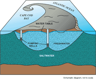
Sea-Level Rise and Drinking-Water SuppliesA concern for Lower Cape Cod water managers is the potential adverse effect of sea-level rise on the depth to the freshwater/saltwater interface near public-supply wells (fig. 11). Pumping from public-supply wells in coastal aquifers underlain by saltwater can lower the water table relative to sea level, decrease the depth to the freshwater/saltwater interface beneath the pumping well, increase the potential for saltwater intrusion, and thereby limit the yield of potable water from the well. Successive increases in the pumping rate can decrease the depth of the freshwater/saltwater interface until a critical distance between the well screen and the top of the interface is achieved, at which point saltwater may be drawn into the well (fig. 11) (Reilly and Goodman, 1985; Reilly and others, 1987). In the mid-1950s, overpumping of wells in the Knowles Crossing well field in North Truro (fig. 1) caused saltwater intrusion, creating the need for additional water-supply wells (Masterson, 2004). In 1955, the Provincetown Water Department began pumping from the South Hollow well field in the center of the Pamet flow lens to meet the increased water demand (fig. 1). Sea-level rise may exacerbate the effects of increased pumping, as was done in the 1950s, and increase the potential for saltwater intrusion into a pumping well. As sea level rises over time, the water table will rise along with it so that the height of the water table relative to sea level will not change. Under these conditions, the depth to the freshwater/saltwater interface below the water table also will not change. However, if the aquifer system were additionally stressed by a high pumping rate, the water table near the well may remain constant or decline even as sea level rises. In this case, the height of the water table above sea level would decrease, as would the depth to the freshwater/saltwater interface. This relation indicates that sea-level rise in coastal aquifers, such as Lower Cape Cod, may result in a decrease in the potential yields of a pumping well that is subject to saltwater intrusion, and may necessitate limiting pumping rates at well fields to prevent saltwater contamination of public-water-supply systems. SummaryGround water is a vital resource on Lower Cape Cod because it is the only source of drinking water and the primary source of freshwater that discharges into kettle-hole ponds, streams, and estuaries. It is also a key component in the maintenance of ecologically diverse habitats throughout the Cape Cod National Seashore. Because of the importance of this resource, the U.S. Geological Survey, in cooperation with the National Park Service, Massachusetts Executive Office of Environmental Affairs, Cape Cod Commission, and the Towns of Eastham, Provincetown, Truro, and Wellfleet, began an investigation in 2000 to improve the understanding of the hydrogeology of the Lower Cape Cod aquifer system and to assess possible hydrologic effects of proposed water-management strategies. This report briefly details the hydrogeology of the Lower Cape Cod aquifer system and discusses the importance of ground-water levels and flow to the functioning of freshwater and estuarine ecosystems of the Cape Cod National Seashore. It includes a discussion of the implications of future changes to the ground-water system and their potential effects on ecosystems and water resources of Lower Cape Cod. Changes on Lower Cape Cod, including land development, population growth, and sea-level rise, have created concerns for potentially adverse effects on the ecology and ground-water flow of the Cape Cod National Seashore. The potential effects of increased loading of nutrients, such as nitrogen and phosphorus, include the eutrophication of fresh and coastal surface-water bodies. The potential effects of increased ground-water withdrawals include declines in pond levels, increases in the depth to the water table beneath inland wetlands, reductions in streamflow, reductions in ground-water discharge to the coast, and increased saltwater intrusion. Finally, the potential effects of rising sea levels include increased erosion rates, damage from higher storm-surge flooding, landward intrusion of seawater in coastal marshes and wetlands, and a decrease in the thickness of the freshwater lens. AcknowledgmentsThe authors thank Kathryn Hess of the U.S. Environmental Protection Agency, and Larry Martin and Charlie Roman of the National Park Service for their helpful reviews of this publication. References Cited
AvailabilityThis report is presented in Portable Document Format (PDF). To view and print report you will need to have PDF Viewer or Adobe Acrobat Reader (available as freeware). Users with visual disabilities can click here for conversion tools and information to help make PDF files more accessible. Printable PDF version (5.5 MB) -- 16 pages Suggested citation for this report, in USGS format: Masterson, J.P., and Portnoy, J.W., 2005, Potential Changes in Ground-Water Flow and their Effects on the Ecology and Water Resources of the Cape Cod National Seashore, Massachusetts: General Information Product 13, 16 p. For more information about USGS water activities in Massachusetts and Rhode Island, visit the USGS MA-RI Water Science Center Home Page. Back to the report's main page |
|||||||||||||||||||||||||||||||