|
U.S. Geological Survey Multibeam Data and Socio-Economic Issues in West-Central San Francisco BayDredge Disposal in San Francisco Bay, I
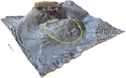
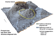
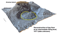
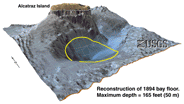
San Francisco Bay has been dredged periodically since the first navigation channel was created in the 1850s (U.S. Environmental Protection Agency and others, 1996). Dredging alleviates shoaling of navigable waterways in the short term but creates the problem of disposal in the long term. Dredge materials have been disposed of at a site south of Alcatraz Island since 1894 (U.S. Environmental Protection Agency and others, 1996). Prior to disposal operations the site was a 50 meters (165 feet) depression in the bayfloor. By the mid-1980s the dredged material (more than 8 million cubic yards) had formed a mound that rose to within 10 meters (33 feet) of sealevel and began, in turn, to pose a threat to navigation by deep-draft vessels. The presence of the mound has generated concerns about the fate, erodability, and dispersive nature of the dredged sediment that composes the mound as well as continued disposal at this site. In the next 50 years another 200-300 million cubic meters (260-400 million cubic yards) of dredge material from San Francisco Bay projects will require disposal (U.S. Environmental Protection Agency and others, 1996). Although other disposal sites exist, in-bay aquatic disposal is still the most economical option for the future. Some perspective views and a cross section of the bay floor near Alcatraz are displayed in the table that follows. The appearance of the hole in the bay floor in 1894 is reconstructed from old navigation charts and the new multibeam data. This is not intended as an exact representation. See a table with larger images (130 kb). A larger version of each thumbnail image can be displayed. Bay floor near Alcatraz
|
||||||||
 larger version (120 kb) |
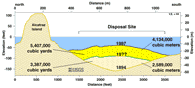 Estimated Sediment Accumulation at the Alcatraz Disposal Site larger version (51 kb) |
 larger version (110 kb) |
 larger version (100 kb) |
Based on the multibeam bathymetric data and old navigation charts, we calculated the shape of the bay floor from its pre-filling shape in 1894 (lower right) through an intermediate filling stage (lower left) to its present shape (upper left). The cross-section (upper right) across Alcatraz Island the adjacent dump site displays the approximate volume of material at each stage.
 |
 |
 |
 |
|
 |
 |

![]() U.S. Department of the Interior | U.S. Geological Survey
U.S. Department of the Interior | U.S. Geological Survey
URL: https://pubs.usgs.gov/of/1998/of98-139/drdisp.html
Contact: John Chin
Page Maintained By: Michael Diggles
Page Created By: Laura Zink Torresan
Page Last Modified: 10 October 2008