USGS - science for a changing world

Western Coastal & Marine Geology

U.S. Geological Survey
Open-File Report 98-139
Version 1.0

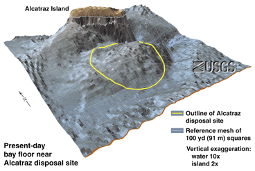
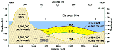
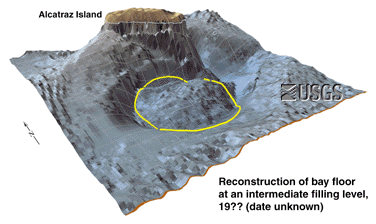
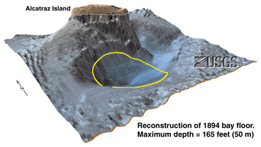
Multibeam Data and Socio-Economic Issues in West-Central San Francisco Bay

Dredge Disposal, II: Computer-Simulated Growth of the Alcatraz Disposal Site

Based on the multibeam bathymetric data and old navigation charts, we calculated the shape of the bay floor from its pre-filling shape in 1894 (lower right) through an intermediate filling stage (lower left) to its present shape (upper left). The cross-section (upper right) across Alcatraz Island the adjacent dump site displays the approximate volume of material at each stage.

Present-Day bay floor near Alcatraz

larger version (120 kb)
This is a view of the bay floor over the dump site (yellow circle) south of Alcatraz Island as it appears today based on the newly acquired multibeam data. The disposal site is now a mound with positive relief above the adjacent bay floor. The vertical exaggeration of the island is 2x and of the submerged features is 10x. The gray mesh is 300 x 300 feet (91 meters).

Profile of Sediment Accumulation at Alcatraz Disposal Site
Estimated Sediment Accumulation at the Alcatraz Disposal Site

larger version (51 kb)
This a north-south cross-section through Alcatraz Island the adjacent dump site. About 8.8 million cubic yards (6.7 million cubic meters) has accumulated in the area since 1894.

Reconstructed bay floor near Alcatraz, 19??

larger version (110 kb)
This is a computer simulation of the bay floor over the dump site (yellow circle) south of Alcatraz Island when it was partially filled. The vertical exaggeration of the island is 2x and of the submerged features is 10x. The gray mesh is 300 x 300 feet (91 meters).

Reconstructed bay floor near Alcatraz, 1894

larger version (100 kb)
This a simplified view of the dump site (yellow circle) south of Alcatraz Island based on surveys that showed a hole in the bay floor 50 meters (165 feet) deep in the area in 1894. This is approximately the natural morphology of the bay floor prior to dredge disposal operations. The vertical exaggeration of the island is 2x and of the submerged features is 10x. The gray mesh is 300 x 300 feet (91 meters).

previousnext


 Title Page of report  Table of Contents of report  USGS Western Coastal and Marine Geology

Accessibility FOIA Privacy Policies and Notices

Take Pride in America logo USA.gov logo U.S. Department of the Interior | U.S. Geological Survey
URL: https://pubs.usgs.gov/of/1998/of98-139/drdisp2.html
Contact: John Chin
Page Maintained By: Michael Diggles
Page Created By: Laura Zink Torresan
Page Last Modified: 10 October 2008