|
Sidescan-Sonar Imagery of the Shoreface and Inner Continental Shelf, Wrightsville
Beach, North Carolina
E. Robert Thieler, William C. Schwab, Mead A. Allison, Jane F. Denny, and
William W. Danforth
Based on USGS Open-file Report 98-596
 |
 |
 |
 |
Click on figure to zoom in. |
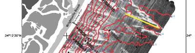
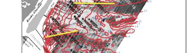
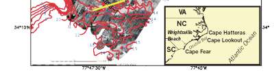
Figure 1. Sidescan sonar mosaic of the Wrightsville Beach Shoreface and inner shelf, showing depth contours, surface grab sample locations, and low-relief ridge axes. The shoreface is the critical interface between the continental shelf and the subaerial coastal plain, and can behave as a source, barrier, filter, or conduit for the exchange of materials between the land and the sea. Oceanographic and geologic processes in this environment determine how a shoreline will respond to storms, to sea-level rise and to human-induced changes in sand supply over time scales from hours to years to millennia. A more complete conceptual understanding of these processes is important for accurate physical modeling of coastal sedimentary dynamics. An applied understanding of shoreface processes is also needed to design coastal engineering projects, as well as to evaluate and improve models used in coastal engineering to predict the behavior of beaches, both natural and artificially nourished.
In this report, we present geophysical and sedimentologic data (Figure 1) collected
on the shoreface and inner continental shelf of Wrightsville Beach, North Carolina (water depths 4-20 meters) in March, 1994, along with a preliminary interpretation that builds on previously and subsequently collected data. This area was chosen for study because Thieler and others (1994) identified a unique tracer sediment from early beach nourishment projects that is petrographically distinct from native shoreface and continental shelf sediment. The initial work (Thieler and others 1994; 1995) identified a dramatic cross-shore morphology of rippled scour depressions on the shoreface that were thought to serve as conduits for cross-shore sediment flux between the beach and the inner shelf. The present study was undertaken to examine further the relationships between surficial morphology and geologic framework of the shoreface and inner shelf. The mapping results presented here suggest that both the surficial morphology and underlying geologic framework play a critical role in modern sedimentation patterns that couple the beach and the inner shelf. |
Navigate through these Web pages by clicking on the "down," "up,"
"next," or "back" buttons on each page or by using the buttons in the frame
at the left side of the screen.
This report is preliminary and has not been reviewed for conformity with
U.S. Geological Survey editorial standards or with the North American Stratigraphic
Code. Any use of trade, product, or firm names in this publication is for
descriptive purposes only and does not imply endorsement by the U.S. Government.
|
|
[an error occurred while processing this directive]
|
|